
Jan de Grijs
It was Monday August 16 and Ursula, Patty and I were starting our long anticipated trip to Greenland. We were on a flight from Reykjavik to Kulusuk on the east coast of Greenland. As we approached Greenland all that was visible from the aircraft window were mountain tops above the cloud. The landing gear went down; we circled; the landing gear went up. Then an announcement came over the intercom, “This is the captain speaking. We are unable to land due to the fog, forcing us to return to Reykjavik.” We returned to Iceland and checked into the Reykjavik Youth Hostel.
The following day we took off again and finally landed in Kulusuk. Here we met up with the rest of the group. There were seven “clients,” two guides, the sailboat skipper and a photographer. We were to use the 60 foot sailboat Aurora as a base for kayaking. Our stay in Kulusuk was very brief though we did manage to acquire a number of Inuit carvings. All too soon we sailed for an overnight trip to the Kangertigtivatsiaq a fjord. Leaving Kulusuk we travelled north and could see the mountains of Greenland and numerous icebergs. The icebergs were farther south than expected so the sailboat’s speed was much reduced.
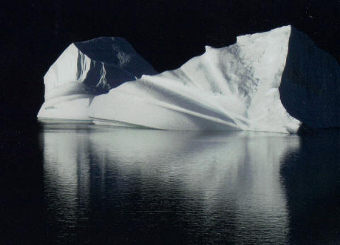
We started the trip at 65° 30′ N and ended at 68° 15′ N – a part of the Forbidden Coast. Along the way we stopped to kayak and camp. The mountains along the coast rise to over 3,000 feet with glaciers emerging through the mountains with numerous offshore islands. The mountains are a series of rugged, jagged peaks with massive steeply inclined scree slopes. There are scattered Inuit ruins along the coast as landing spots are infrequent. Added to the difficulties is the Denmark Straight between Greenland and Iceland which has a strong current and can be blocked by ice. The ice pattern has changed in the past years and there are now flat topped Canadian icebergs present. They travel from the high Arctic around northern Greenland. Many of the icebergs we saw were monsters. Scale in Greenland is impossible to comprehend. One looks ahead and sees one’s proposed destination which looks close by but it takes an hour to get there. There are few land mammals; for the landscape is almost devoid of vegetation though in some sheltered locations there are patches of wildflowers. There are many active glaciers along the coast spawning numerous icebergs. The bergs are relatively stable with little melting occurring due to the lateness of the season. We saw many seals, whales, dolphins and seabirds.
We arrived at our destination, an inlet at the southern tip of Storø, an island at the mouth of the fjord in the early morning asleep in our bunks. From the cockpit the views were stunning: mountains rising abruptly from the sea and scattered about in the inlet were icebergs. Soon after breakfast we were ferried ashore together with our kayaks and gear to a small rocky beach a short distance from where the sailboat was anchored. We stowed four days food and gear and set off on our initial paddle.
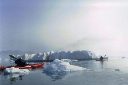 We paddled into fjords with their bays and inlets and camped for three nights. The fjords were awe inspiring with icebergs and bergie bits. Camping was on areas with landing spots and campsites. Fresh water was usually some distance away. The meals were prepared by the guides and the food was excellent. Sitting at our campsites eating our meals could see the mountains, glaciers and icebergs. We did have about six hours of darkness. Polar bears were known to be active in the area though we never did see one. However, when ashore shotguns were always present and around the campsite polar bear watches were kept. (One hour per person.) In the darkness strange sightings would occur when we peered at the dark waters of the fjord; drifting bergie bits took on the appearance of polar bears swimming in the water. If one saw a polar bear one was to raise the alarm and awake all in their tents. It never happened.
While paddling in the Kangertigtivatsiaq area we could hear the blow of whales and see the plumes of their spouts in the distance. We spotted them in a number of locations. Some were humpbacked whales and we could see them as they breached. It was almost impossible to photograph them for one rarely had a camera ready when needed. The second night’s campsite overlooked a fjord with icebergs and whales swimming around. We spent hours observing them.
We rejoined the sailboat and headed north to Kangerlugssuaq Fjord, one of the largest in East Greenland. This is the location of the Skærgård Igneous Complex. In this area we were not to camp for there were concerns about polar bears, so we overnighted on the sailboat. We did a number of day trips launching from the sailboat using the zodiac as a platform; usually entering and exiting the kayaks in an undignified manner. The first day’s planned activity, a paddle through Watkins Fjord, was adjusted due to extensive fog. We did paddle out to inspect Inuit ruins. The shorelines in this area were beautiful mountains rising overhead and icebergs all around. Patty commented, “The icebergs look like an emerald city.”
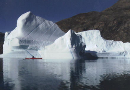
We did finally did paddle through Watkins Fjord. It was cluttered with icebergs and route finding was not easy. At times we were very close to the ice. On one occasion we were watching an iceberg and it started to roll. We heard a tremendous crack as a monster chunk of ice plunked into the water and generated a huge boiling turbid wave. The deep waters of the fjord quickly absorb the wave’s energy and the kayak bob up and down the high energy wave. When these waves hit shore a tsunami like effect occurs, a backwash and a surge onto the beach. Deep water fjords generally do not create turbulent waters. We saw very little of the mountains surrounding Watkins Fjord due to fog and cloud. Whilst paddling close to the shore, we saw that the coastline was almost devoid of vegetation. I don’t think I have ever seen a place so barren but still very beautiful.
We moved to J.C. Jacobsen Fjord and anchored in an inlet with rapidly receding glaciers. Throughout our stay we could hear the crashing of ice within the body of the glacier, though we seldom saw anything. The noise is referred to as the Greenland Artillery. We did a day paddle and came across the most pristine Inuit ruins I have ever seen. This fjord had probably been visited by very few people. The scenery was staggeringly spectacular, the mountains forming ragged spires along their ridge lines. There were numerous heavily crevassed glaciers high in the valleys. There were some rocky beaches on one of which we stopped for lunch and to admire the landscape.
 We were away for three weeks, two of which were in Greenland. The rest of the time we spent in Iceland. It was a commercial trip. We had good weather and the water was mostly flat. It is possible to rent kayaks in Greenland but this presents logistical nightmares. The tour company we were with was Explorers Corner. 2010 was the first year commercial kayaking trips were offered in this area. There were two trips with the total number of clients being 14. These trips will again be offered in 2011 but the latest news is that there is a waiting list of 23 people. This was the first time Ursula had been in Greenland; for Patty and me it was our eighth. We all enjoyed the trip and the people on it were great companions.