
by Donna Griffin-Smith
Usually a paddling trip involves much advance planning, but our “Superior Adventure” last summer, from the first “Would you like to…?” to the final “I think we’re ready!”, was two weeks of frantic planning and packing.
Martha, Vicki, Catherine and myself were all experienced trippers, but we had not paddled together as a group before. Therefore we had not only the logistics of who brings what to discuss, but we also needed to clarify our expectations for the trip. Over a delicious summer supper at Vicki’s we worked out the details of equipment, route, maps and menu. The more difficult challenge for a newly formed group – how to make decisions that might be critical to our safety en route – was thoroughly discussed as well, and from the beginning we seemed to have the correct formula for reaching consensus.
We met at Michipicotin where we camped on the beach at Naturally Superior Adventures, and made final preparations. Although we were self-outfitted and paddling on our own, Dave, Peter and Craig were wonderful hosts. They gave us all kinds of advice, let us use their beach, part of their freezer and their kitchen, and went over the route with us the evening before our departure. The next day Dave shuttled our equipment to Hattie Cove in Pukaskwa National Park and returned our vehicle to trip’s end. My only complaint was the mouse that spent the duration of the trip in my glove compartment.
I have never yet started a trip before noon and this was no exception. Tying boats onto the trailer, the restaurant stop for breakfast, registration at the park – all these things take time. And of course I’m sure the reason Dave hung around until after the boats were loaded was because he thought we would never get all that stuff in those four little boats. After he took the official portrait we were finally ready to launch.
Hattie Cove is a small, very sheltered bay and an ideal place to begin or end a trip on Lake Superior. Our planned route would take us south and then eastward to finish at the Michipicotin River, a distance of about 180 km. About half of the trip is within the boundaries of Pukaskwa National Park. You must register and pay a small daily fee for use of campsites which serve both coastal paddlers and hikers using the Coastal Hiking Trail. Fireplaces, privies and either bear proof boxes or bear poles are provided at most marked sites, but camping is also permitted at any other location if you wish.
We used topographical maps, which I ruthlessly cut into strips with my nail scissors to avoid taking the unnecessary sections of land or open lake. As well we relied on Craig Zimmerman’s guide Teasing The Spirit to locate points of interest and campsites. The book also provides interesting insights into the history of the area, including the legends of the Anishnabe. The National Park too has a map and guidebook, but it only covers the section within the park.
Because we had plenty of time, our plan was to make this a leisurely trip, taking time for side trips and exploration to see all that interested us along the way. We decided we would not paddle if we were tired or if weather conditions were marginal. Therefore we took 12 days, although the trip could easily be done in less time. We paddled every day, and enjoyed good paddling conditions most of the time, with only one day of rain. In fact in some ways the weather was just too perfect. A week of hot sunny conditions had heated the land so that a dense fog bank formed along the coast where the warm land and cold lake water met, and for several days we paddled and camped in fog and mist, while inland was hot and sunny.
Day 1
We are camped at the south end of Pictured Rock Harbour, so named because the native people used to make pictures on the rocks by scraping away the lichen. There’s a sand beach for the boats and a rice rocky point for the kitchen and sitting. My tent is tucked into a tiny spot just the right size in the forest. It was a nice sunny day – light winds and a short easy paddle from Hattie Cove. It’s peaceful and calm as we sit and watch the sky change to sunset colours.
Day 2
After a delicious breakfast and a three hour start, we were on the water. At the White River we took a “little” side trip. Vicki and I fought the current 5 kilometres upstream to the White River gorge while Martha and Catherine waited patiently for us at the river’s mouth. At the gorge we hiked to the suspension bridge that was built for the coastal hiking trail to cross the river and cautiously crept out to look down at the raging torrent below. Hours later, back at the lake we had a late lunch and paddled southwards to the Willow River where we set up camp on a wonderful sand beach. That evening nature provided the grand finale to a perfect day of paddling – a gorgeous sunset in the west and a double rainbow in the east. The Spirit smiled on us today.
Day 3
Another perfect day – sunny and warm and calm. No wind, just little breezes now and then. We followed the shoreline closely, in and out of every bay, paddling between rocks and through narrow passages. I call it rock hopping. Martha says we do it just because we can.
The rocks along this section of the coast tell a fascinating tale of geological events and human history, and we were lucky to be able to paddle so close. We were fascinated by the endless variations on the theme of rocks – black basalt columns, white quartz, grey and pink granite cliffs, cobble beaches, boulders and sandy shorelines. For hours we searched the cliffs for a pictograph that was supposed to be there, but we never did find it. At Shot Watch Cove we went ashore at an ancient cobble beach and searched for our first Pukaskwa Pit. Although we found more spectacular pits farther on, this discovery was exciting. Pits are found on raised cobble beaches, which are former shorelines from a time when lake levels were much higher. These steep beaches of large rounded boulders extend upwards and back into the forest, and are usually located along exposed shorelines.
The pit, when we found it, was easily recognized as something man made, a circular depression about 4 feet deep and about twice as wide, but gently camouflaged by the lichens covering the rocks. Although it is not certain why these pits were made, there are many theories. The most widely accepted is that they served a ceremonial purpose for fasting and vision quests. One at Tug Harbour had raised sides and an entrance as if used as a blind for hunting. On some beaches, large flat areas of small stones reminded me of a place to put a tent. Perhaps an ancient camping place?

Our days soon fell into a happy routine, as we tried to get on the water early (but not too early) and stopped to hike and explore the beaches or took side trips up rivers to photograph waterfalls. After lunch we often relaxed for an hour or so, rinsed out laundry and took quick dips in the frigid lake. If the winds picked up we would wait until late afternoon when the wind dropped before paddling on.
Day 5
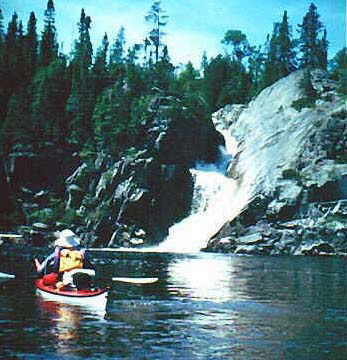
This afternoon we spent at Cascade Falls. We discovered that the water in the falls was much warmer than that of the lake. We found a ledge to sit on under the falls – a shower and turbo-bath all in one – and smooth rocks at the base of the falls ideal for sun bathing. A superior spa.
It was tempting to stay and camp at Cascade Falls, but we paddled on that evening to nearby Otter Island. Here an automated lighthouse marks the coast for passing boat traffic, and there are two houses, formerly occupied by the light keepers. These empty homes are in good condition and left unlocked so that passing boaters can use them, but we preferred to camp on the lawn. We climbed up to the lighthouse just in time to watch an orange sun dip below the horizon, followed by a crimson afterglow that reflected for an hour in the perfectly still water.
Day 6
We took advantage of the morning calm to paddle along the base of the cliffs on the outer side of Otter Island. At its southern end we landed at a cobble beach to search for a fort-like structure that we had learned about from some other boaters. A short hike up a cobbled trail led to several raised beaches back in the forest where we found a large rectangular enclosure that I estimated to be about 100 metres long and 30 metres wide. The walls of piled up cobblestones were about a metre high and there was one small entrance way. Inside were several smaller circular enclosures. I felt a sense of mystery and wondered who had built such a structure and what purpose it could have served – perhaps a ceremonial site?
At Imogene Cove we camped near the site of Pukaskwa Depot, a former logging camp. Hot muggy weather and hoards of mosquitoes made the search for old ruins in the overgrown forest quite an unappealing venture. So we passed, opting instead for a quick swim and an early evening inside the tents. I read later that there is an old cabin and a gravestone there somewhere, but they weren’t visible from the beach. A good reason to return another time!
Day 7
As the wind picked up it was also getting foggy. As the waves grew bigger it became more dangerous as we had to hug the shoreline due to the fog. Vicki led the way and we all followed her like ducks. Finally after 4 or 5 km we found a good place to stop – a nice flat rock to land on and a sheltered bay with no fog. The fog lies just along the shoreline as the water is so cold and the land so warm.
From our sheltered bay we hiked along the shoreline to Chimney Point, a high promontory marked on our maps. We had hoped to hike as far as the Wheatbin, known as one of the finest sand beaches along this coast, but steep cliffs and thick forest made the route impossible. Back at our bay, Catherine began some serious rock collecting, a passion that spread among the group, and soon we were all keeping a sharp eye for possible agates and other unusual stones.
Around 6 p.m. the wind had dropped significantly so we decided to paddle on to a campsite shown on the map near Crane Island, about 9 kilometres away. It was still foggy but calm and very pleasant paddling. However, our proposed campsite was already occupied so we had to continue on. Soon the peaceful fog became a nuisance as it hid potential campsites from view. Finally at Ganley Harbour we found the “campsite from Hell” as we fondly named it – so small there was barely room for our tents, and the kayaks were pushed into the trees, as there was no beach. The only plus was there were no bugs. Even the mosquitoes considered it a waste of time here. Somehow Vicki managed to find firewood, light a fire and make a steaming pot of “midnight soup” while we struggled with gear, boats and tents in the dark.
Day 8
It took a campsite like the one at Ganley Harbour to make us appreciate Floating Heart Bay – wide sand beach, warm stream and bathing pool, small meadow with wildflower garden, lots of driftwood for the campfire. Ideal. We stopped early and took advantage of it. I fondly remember an afternoon siesta with the music of bees buzzing outside my tent.
Day 9
Floating Heart to the Flats. Distance 8 km. Time 9:15 to 12:00. A short paddle today. Weather is cool, damp, foggy and rain showers. We have paddled to the last possible campsite before Point Isacor.
Point Isacor loomed over us. We dreaded it. Our guidebook cautioned that only “foolish” paddlers would venture along its 5 kilometres of cliffs in “less than perfect weather.” And that was the kind of weather we had, so we camped. But we created the perfect foul weather campsite in a thicket of spruce, complete with a wind and rain shelter built of two tarps. That afternoon the wind blew surf onto our beach, but we were safe and secure. The last of the lingering fog blew away too, as rain showers alternated with sunny breaks.

Day 10
The next morning we continued to have less than perfect weather, as two thunderstorms hurried by during my turn to cook breakfast. But the water remained fairly calm and the wind direction promising, so we started out. After we rounded Point Isacor, we were in the lee of its high cliffs and enjoyed calm water. With this major obstacle behind us we continued eastward to False Dog Harbour, exploring the rocky coastline. The iffy morning weather turned into a beautiful sunny afternoon with winds that kept changing direction, and finally blew back the fog.
Day 11
We paddled only 2 kilometres, to the University River, also known as the Dog River. We planned to hike upstream a distance of 2 kilometres to Dennison Falls, but it seemed much farther, especially when we lost the trail and tried unsuccessfully to create our own. At last we spied a rope hanging down a cliff face – the only way up – and recovered the trail. However, this spectacular falls was definitely worth the effort, and after an appropriate amount of time spent taking photos and climbing up the rocks beside the thundering chute, we returned to the lake by mid-afternoon. Inland it was warm and sunny. On the water a strong easterly wind had whipped the lake into whitecaps and huge standing waves at the river mouth. With no regrets we set up camp on the gravel beach. We were not alone – six other wind bound paddlers shared our campfire. And the rock collectors were in seventh heaven! In fact this is where my kayak started to get a little heavier.
Day 12
The shoreline from the University River to Minnekona Point is low and rocky, with beautiful pink granite and long sand beaches in almost every bay. Along the way we passed many potential campsites – McCoy Harbour and Minnekona were evidently favourites. But we paused only to rest, eat lunch, and search one more time for that elusive, perfect agate. We knew it was possible to finish the trip if we put in a long day of paddling, and it is strange how that desire takes over once you realize the distance is possible.
The final obstacle was Perkwakia Point, which forms the western side of Michipicotin Bay. As we rounded the point and could see our final destination several kilometres distant across the bay, a strong northeasterly wind pushed us back.
“Not as easy as you think,” whispered the Spirit, “I will tease you just once more.” Someone suggested a Werther’s butterscotch candy in place of the traditional tobacco to appease the spirit. “Why not?” I thought, and let one slip into the water. We bowed our heads to the wind and paddled on.