
by Doug Cunningham
The trip along the Georgian Bay shoreline of the Bruce Peninsula from Lion’s Head to Barrow Bay is approximately 12 kilometres in length. One should allow the better part of a day to enjoy it as a day-trip, or could make it a leisurely two-day trip by camping at McKay’s Harbour where an old logging road leads up to the Bruce Trail.
The Lion’s Head Promontory and its backcountry regions are classified as an Area of Natural and Scientific Interest. Paddling this section of the escarpment provides a rich opportunity to experience first hand its many natural wonders – from the rich fossil history, through the beautiful cliff ecosystem with its rock climbers and old growth cedars, through to the hiking trails that radiate out from McKay’s Harbour and into the wildflower rich woodland.
These shores are exposed to the north, east, and southeast, with no barrier lea protection. Wind and waves can combine to produce conditions which would challenge experienced kayakers. The waters are cold, deep, and the reflection of the waves from the escarpment shoreline produce clapotis that makes paddling challenging. When rounding the Lion’s Head Point beware of surf accompanying strong north and east winds. Get an accurate weather and wind update before venturing out.
The best time to make this trip is May through September. There is very little shoreline development as this is a Provincial Nature Reserve but there are cottages at the south side of Lion’s Head Harbour and along the shore adjacent to the entrance to Little Lake at Barrow Bay. Lion’s Head provides the main harbour north of Wiarton and is the home base to many sailboats and motorboats. On summer weekends there is considerable traffic in and about the harbour mouth. Exercise caution when entering or leaving this area. In addition caution should be exercised when entering the narrow entrance to Little Lake at Barrow Bay. Parking is available at the Lion’s Head Beach Park and Barrow Bay-Little Lake boat launch.
POINTS OF INTEREST
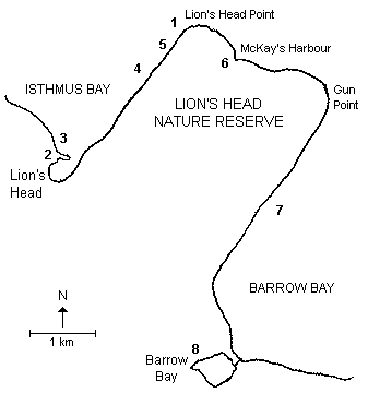
- Lion’s Head: There are number of unidentified shipwrecks in Lion’s Head Harbour; the shallowest is a 42 metre long schooner that can be easily seen from a kayak. Looking out from the Lion’s Head Beach you can see Point Hangcliffe, the highest section of this section of the escarpment, and farther along, at the end, you can detect the outline of the famous lion’s head.
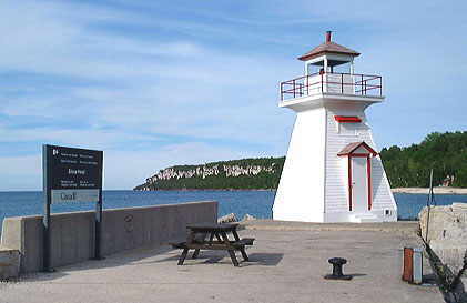
- Lighthouse: A replica of the Lion’s Head Lighthouse has been constructed just to the north of the breakwater by students of the Technical Department of the Bruce Peninsula District School. The original lighthouse, which had been built on the end of the breakwater near the entrance channel, was disassembled and destroyed by the Coast Guard in May 1969. Lion’s Head residents still mourn their loss and anchor ends in the concrete pier still mark the original location.
- Brachiopods: Just north of the breakwater at Lion’s Head the pebbles and cobbles are full of fossil corals. As well, located in the large dolomite slabs on the beach are abundant brachiopods.
- Cliff Climbing: Paddling along the massive cliffs and talus slopes of the Lion’s Head Nature Reserve you will become aware of rock-climbers. Some of the best dolomite rock climbing in North America is to be found here, and watching ascents from the seat of your kayak is certainly entertaining.
- Old Cedars: The “Old Growth Cedars” which cling tenaciously to the exposed dolomite cliff faces represent the oldest undisturbed plant community in Ontario. Some of these cedars are more than 1000 years old and represent a valuable record of past climate changes.
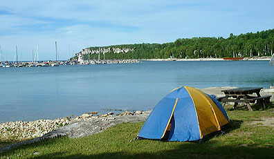
- McKay’s Harbour: This harbour is located about a kilometre beyond the Lion’s Head Point and was the site of a summertime fishing camp, complete with bunkhouses, docks and fish packing facilities, until 1913. It is not a particularly good harbour because of its eastern exposure and partially submerged boulder barrier reef. The beach itself is a mixed beach of sand, cobbles, and hardhead boulders. If conditions permit, however, it is worthwhile stopping or camping at the Bruce Trail Campground and then exploring the back trails of the Lion’s Head Nature Reserve. Wildflowers, karst topography, and magnificent scenic vistas await the explorer.
- Cliff Paddling: From McKay’s Harbour past Gun Point to Barrow Bay is a pleasant paddle in calm conditions. The shoreline is talus slope, cobble beach, and exposed cliff, but be warned, until you reach Barrow Bay there is little opportunity to egress. The Bruce Trail winds along the top of the cliffs and you will see a number of hikers during your journey.
- Water Falls: The boat launch area at Little Lake is located next to a set of the waterfalls produced when the waters of Judges Creek descend the escarpment. In spring the falls are quite energetic and produce spray and roar in abundance.
Lion’s Head Nature Reserve, Georgian Bay
ADDITIONAL INFORMATION
Maps
Maps: 1:50,000 Dyer’s Bay (41 H/3); Cape Croker (41 A/14)
- CanMatrix – Print Ready – 041H03 – Dyer’s Bay, Ontario
- CanMatrix – georeferenced – 041A14 – Cape Croker, Ontario
This is one in a series of Bruce Peninsula paddling trip descriptions written by Doug Cunningham for the Georgian Bay Committee. It was originally published in the Summer 2000 issue of Qayaq.