
by Doug Cunningham
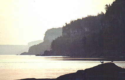
The east coast of the Bruce Peninsula offers a number of paddling options, from short day trips to an extended 35 kilometre paddle covering the entire distance from Cabot Head to Lion’s Head. Spectacular dolomite cliffs, a mainland flowerpot formation, an escarpment waterfall, cobblestone beaches, and relatively wilderness paddling await the kayaker along this stretch of the Bruce Peninsula. The coastline is exposed and the paddling conditions are challenging when north and easterly winds buffet the shore. The scenic vista of the Niagara Escarpment cliffs and headlands extends continuously to the southeast as far as the eye can see. A pleasure to paddle and explore!
The waters here are deep and cold and when the winds are from the east or north the waves are challenging. Pay attention to the winds and weather and wear cold water immersion apparel, such as dry suits or wet suits, when paddling this area particularly during the early spring months. Certain sections of the coast are isolated and don’t provide any convenient exit, in particular, the areas between White Bluff and Smokey Head, and between Dyer’s Bay and Cape Chin North. Poison Ivy is rampant along the shore. Be cautious of the Massassauga Rattlesnake if you decide to explore the swamps and forested areas adjacent to these shores.
The best time to make this trip is May through September. There is cottage development at Dyer’s Bay, Cape Chin North, Cape Chin South, Whippoorwill Bay and Lion’s Head. This section of the Bruce Peninsula attracts mainly sailboaters and some fishermen. The highest concentration of boat traffic will occur at the Lion’s Head Harbour; take special care at the harbour entrance. The boat launch facilities at Dyer’s Bay has only light boat activity, even during the summer months.
There are a number of access points along this stretch of the peninsula – Cabot Head, Dyer’s Bay, Cape Chin North, Cape Chin South, and Lion’s Head – giving the paddler a good deal of flexibility in planning a trip. (If you are leaving a car in the parking lot at the Cabot Head Lighthouse, a donation to the Friends of Cabot Head Lighthouse, who maintain the lot, would be appreciated.)
POINTS OF INTEREST

- Cabot Head Lighthouse: This lighthouse was originally built to mark Cabot Head and the entrance to and went into operation in 1895. The current building, with its replica tower and lantern, is open to the public in the summer and provides displays interpreting the area’s rich natural and human history. Parking is available.
- Inuksuit Beach: About 2.5 kilometres south of Cabot Head is a raised limestone shingle beach on which people have constructed about 100 rock cairns, many modelled after the Inuit’s Inuksuit – stone cairns in the shape of a person.
- The Flume and Gillies Lake: A worthwhile stop for the kayaker is the “Flume,” the remains of the old log chute constructed by the Lymburner family to supply logs to their small saw mill which was located along the shore beneath the outflow from Gillies Lake. You can readily identify the site by the V-shaped indentation at the shore and the small waterfall that exits to the Bay under a road culvert.
- Devil’s Cliff: About 1.6 kilometres south of Dyer’s Bay is a fascinating cliff formation with clefts, some wave action caves just beneath the escarpment top and, in the talus slope at the bottom, some interesting boulder passages.
- Devil’s Pulpit: About 3 kilometres south of Dyer’s Bay is the largest flowerpot formation on the mainland Bruce Peninsula. It was formed about 5000 years ago by the wave action of Lake Nipissing. The flowerpot formation is located about halfway between the shore and the escarpment top. There is an interpretative plaque at the site.
- Smokey Head Nature Reserve: This Nature Reserve has been designated an ANSI area and contains a variety of Georgian Bay shoreline habitats.
- Reed’s Dump: This is a campsite for Bruce Trail hikers and provides easy access to the escarpment top and the Bruce Trail. The views of Isthmus Bay from the top of White Bluff makes the effort of taking a half-day hike to the south worthwhile.
- White Bluff: This spectacular limestone cliff face rises almost 65 metres above the Bay and provides some of the more challenging dolomite climbs for rock climbers. You may see both Bruce Trail hikers and rock climbers from the seat of your kayak.
- Brachiopod Fossils: As you paddle south from White Bluff you will see a shoreline of dolostone bedding planes backed by cobble beaches. These dolomite planes and outcrops contain numerous fossils particularly the brachiopod Pentamerous.
- Lion’s Head Cliffs: These cliffs are given an ANSI designation because of the bedrock outcroppings and glacial features that depict previous glaciation episodes. Indeed, the highest concentration of “Indian Potholes” in Ontario is found here. The Lion’s Head outline at the end of the cliffs can be readily seen when paddling south from White Bluff.
- Lion’s Head: Called the prettiest village in Ontario, this community has an excellent natural harbour, and provides all the amenities of modern civilization, from banking, through medical care and pharmaceuticals, to shopping for food and gifts. Camping is available at the Lion’s Head Campground adjacent to an excellent sand beach. Motel facilities plus two licensed restaurants and an LCBO store are also available. Parking is available at the marina.
ADDITIONAL INFORMATION
Maps: 1:50,000 Dyer Bay (41 H/3), Cape Croker (41 A/14)
This is one in a series of trip descriptions collected by the Georgian Bay Committee for a paddling guide to the Bay.