
by Doug Cunningham
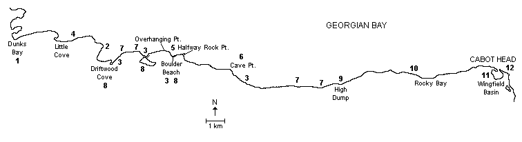
The northeast coast is without a doubt the most spectacular part of the Bruce Peninsula. The rugged escarpment cliffs combine with the crystalline clear blue waters of Georgian Bay and the off-shore islands of the Fathom Five National Marine Park to create scenic vistas that are unrivaled anywhere. The trip from Dunks Bay to Wingfield Basin is at least 30 kilometres, depending upon how many coves and inlets you explore, and will take at least two days depending upon the weather and how much exploring you do.
Some of the most interesting paddling in Georgian Bay can be found along the shoreline of Bruce Peninsula National Park because of the unique geology of the Niagara Escarpment. The kayaker will encounter numerous sea caves, talus slope caves, a grotto, a number of cobble beaches, Silurian fossils, pitted dolomite limestone pavements, ancient cedars and numerous back country Bruce Trail day hikes. Camping is allowed in the park Loon Lake, the Ledges and High Dump. (There is a camping fee and reservations are needed.) Open fires are not permitted, so take a stove.
This section of the Bruce Peninsula provides an opportunity to experience Lake Superior paddling without going to Lake Superior. The cliff-bounded waters are cold, deep, and open to a long wind fetch. Winds from the west, north, and east can combine with the rugged shoreline and cliffs to produce the most energetic waves and reflections. Combine this with the fact that for certain stretches there are no exits and you have the potential for misfortune. Beware and check the latest wind and weather forecast before venturing out. Immersion paddling gear is recommended if you are paddling early or late in the season. The area also has abundant poison ivy.
The best time to make this trip is May through September. As most of the shoreline is part of the Bruce Peninsula National Park, there is little shoreline development, except for a few cottages at Dunks Bay, Little Cove and Driftwood Cove. Be prepared to share your solitude with Bruce Trail hikers until you reach High Dump and day-hikers in the vicinity of the Cypress Lake campground. Boat traffic is generally light, but tour boats from Tobermory bring divers and sightseers to the Grotto and Cave Point.
Dunks Bay is an ideal starting point for the trip, offering parking, washrooms and public access to the water at a sand beach. The trip can be completed at the Cabot Head Lighthouse where the Friends of Cabot Head Lighthouse maintain a parking lot. (A donation to the Friends would be appreciated if you are leaving a car here.) The road to the Cabot Head Light runs out of the village of Dyer’s Bay.
POINTS OF INTEREST
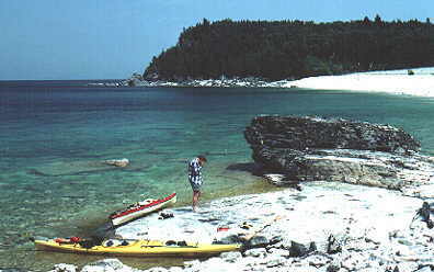
- Dunks Bay: Departure point, parking, washrooms and public access to the water. (Note that the beach on either side of the fenced road allowance is privately owned. Please respect the rights of the property owners.)
- Stepped Dolomite Platforms: One of the joys of paddling these clear, transparent waters is the flying sensation one gets while paddling over the underwater rock formations. When these underwater formations are “stepped dolomite rock platforms” then the effect is even more pronounced and visually appealing. These stepped rock platforms occur in many areas from Driftwood Cove to Halfway Dump and vary in thickness from less than one metre to several metres.
- Cobble Beaches: These beaches make up about 25% of this northern shoreline area with significant beaches at Little Cove, Driftwood Cove, Loon Lake Beach, Marr Lake Beach, Halfway Dump and High Dump. These areas provide shelter in the event of the inclement weather and the adjacent Bruce Trail provides an opportunity to safely climb the escarpment sections and enjoy the cliff vistas.
- Dolomite Stacks: Wave action by past lake activity (Lakes Algonquin and Nipissing) have eroded the escarpment cliff face into fascinating arches, stacks, and notches. Adjacent to the south side cliffs bordering Little Cove and also near Hallway Dump are a number of impressive dolomite stacks, best viewed from the seat of a kayak.
- Cliff Formations: A kilometre of shore paddling along either side of Boulder Beach near Marr Lake provides the paddler with three fascinating geological formations. The first, Overhanging Point, on the western side of Boulder Beach is an extension of dolostone caprock projecting out from the cliff edge about 30 metres above Georgian Bay. Just behind it is an entrance tunnel, called Lord Hunt’s Tunnel, that will take you to the shelf below. The second feature are the Grottoes, located just to the east of Boulder Beach. These water carved caves are fascinating and one of them is 20 metres long by 9 metres wide and is connected to Georgian Bay by an underwater tunnel visible from the kayak as a patch of light. You will almost certainly come across divers exploring this underwater cave entrance during the summer months. The last feature in this area is Indian Head Cove. This pretty cove is named for the profile of an Indian face on the dolostone cliffs.
-

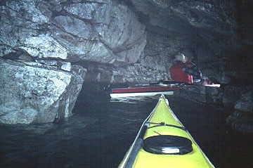
Exploring the Wave Action Caves Wave Action Caves: Cave Point, located between Stormhaven Beach and just to the west of Hallway Dump, provides a number of examples of “Wave Action Caves.” The cliffs here vary in height from 40 to 50 metres and the caves are located from 3 to 10 metres above Georgian Bay. The largest cave is located on the northwest side of Cave Point and measures about 10 metres high and 17 metres deep. The shoreline is littered with extensive large rocky debris and access is difficult and only possible by the water.
- Old Growth Cedars: The exposed escarpment cliff face is home to the oldest undisturbed forest community in Eastern North America. Since 1985 the Cliff Ecology Group of the University of Guelph has studied the age distribution and ecology of the Eastern White Cedar (Thuja occidentalis) growing from cracks in the cliff face. They have found specimens with life spans of over 1600 years. As you paddle beneath the cliffs pay attention to the old gnarled cedars tenaciously clinging to the cliff. They are survivors and very old!
- Lagoons: Along the northern coast there are three significant lagoons, which are separated from Georgian Bay and landlocked by boulder beaches. These are located at Cooney’s Cove, Loon Lake Cove, and Boulder Beach near Overhanging Point.
- High Dump: This is one of several such old log dumps along the coast. During the days of logging, the lumbermen hauled their timber in winter to these spots on the edge of the escarpment, and dumped the logs onto the beaches until spring. The logs were then formed into rafts and towed to mills in Dyer’s bay, Lion’s Head and Wiarton.
- Clay Cliffs: The “Clay Cliffs,” located just to the west of Rocky Bay have sedimentation boundaries of varying colours and thickness. These form a geological window into past sedimentation phenomena. The escarpment vistas of West Bluff and Middle Bluff as seen from Rocky Bay are spectacular. Be careful with the Poison Ivy behind the cobble beach.
- Wingfield Basin: Wingfield Basin, once a fishing harbour and the location of a small lumber mill, is now a feeding habitat for colonial water birds and supports fur bearing mammals (beaver) while at the same time providing a sheltered anchorage for small craft. Within the basin is the remains of the wreck of the tug, Gargantua, abandoned there in December 1952 after she sprung a leak. It is possible to come ashore here and portage your kayak up the short 0.5 kilometre trail to the Cabot Head Lighthouse.
- Cabot Head Lighthouse: This lighthouse was originally built to mark Cabot Head and the entrance to Wingfield Basin and went into operation in 1895. The current building, with its replica tower and lantern, is open to the public in the summer and provides displays interpreting the area’s rich natural and human history. Parking is available.
Bruce Peninsula – Northeast Coast
ADDITIONAL INFORMATION
Maps: 1:50,000 Dyer Bay (41H/3), Dorcas Bay (41 H/4), Flowerpot Island (41H/5)
Camping: For further information and campsite reservations, contact Bruce Peninsula Park at (519) 596-2233.
This is one in a series of trip descriptions collected by the Georgian Bay Committee for a paddling guide to the Bay.