
by Daniel K. Jenkins Well this is a first for me so don’t be too hard on me. I feel like I’m in grade school and doing a “What I did on my summer vacation” report. Having only been on a few day trips, the Rendezvous and one extended trip with one other member it was with great anticipation and some reluctance that I signed up for this trip.
Day 1
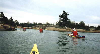
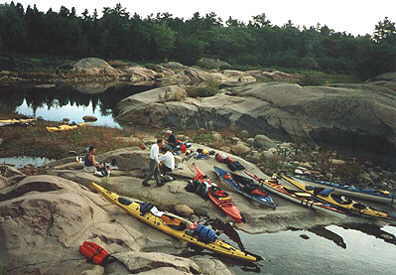
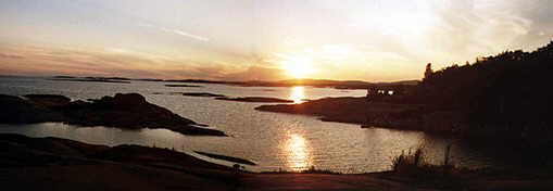
I had talked to Hart the day before to arrange a shuttle and met him and Bob Graham at the Hartley Bay marina. We left our vehicles and loaded all into Bob’s truck (it’s amazing how 3 people can fill the back of a pickup with gear) and we were on our way. Once at Chikanishing River put-in in Killarney Park there was a flurry of activity of people getting boats ready and meeting the members of the trip. By noon we were on the water and starting our trip. Once we rounded the eastern tip of Philip Edward Island and headed into the prevailing winds, thoughts of work, did I leave the coffee maker on and such, quickly faded into nothingness and the water, rock and trees filled our senses with never ending beauty. Making our way down the coast to the Foxes, we stopped for lunch on a great flat rock in a secluded bay. We spent the time eating and getting to know fellow trippers/members better. After lunch we had to do one of our larger crossings (about 5 km). There were easy waves and a nice breeze to keep you cool. When we got to the west side of the Big Rock Portage we were able to take some sheltered channels and see some of the rock formations up close. We made our way around the point and camped on a huge flat rock site on the east side of the portage. It was not long before the tents were up and supper was on and we had quite a social evening getting to know more and more of what each other had done and wanted to do. Greg, the “Trip Photographer,” was snapping pictures and it was not long before the evening came to a close with a nice sunset, quiet time and off to bed.
Day 2
We were up early and the action around camp was in full force by 7 a.m. – breakfast cooking, coffee on and tents coming down. Rumour has it that Hart was up before everyone and had a swim. Bob found what at first was thought to be the largest arrowhead I had ever seen, but when a second one was found we decided that they were the tips from an old anchor. It was added to Hart’s “Rusty things I’ve found” collection. John gave us a weather check and all was ok. By 9 we were all on the water in the prevailing tailwinds. I was put in charge of navigating since I had been in area a few weeks before and knew all the dry channels and passageways. We made our way down through the channels of the Chicken Islands and stopped at a great hidden beach for lunch. Bob had found some turtle tracks but it must have scurried off when it heard us coming. We had a nice break and were back on the water in a decent time. We had our next crossing ahead of us now – about 6 km. After a bit I thought land was getting farther away or someone had grabbed hold of my boat and I was dragging him or her across. We made camp near Eagles Nest Point on Green Island. I got all set up and lay down for an hour, then got up and made my supper. I learned some of the finer points about Menu Planning and Packing Light from Wayne. We had our usual evening social and photo shoot and then off to bed for the night. The night brought in a windstorm that kept the better part of the group up most of the night.
Day 3
I was first up so made as little noise as possible. Soon, all started to emerge with their stories of how the wind kept them up and how their tents almost collapsed. Hart had his swim and attracted a few onlookers to see how it was. Sam decided to do a bit of solo practice and paddled back to Killarney. He set off about 8 and within minutes was around the point and out of sight. The sky was overcast and we had our first bit of Liquid Sunshine for a few seconds before putting on the water in the Prevailing Tailwinds. The day took us through many channels and passageways that included a few bumps and scrapes as well. Along the Fingerboards I saw what I thought was a stick in the water. Once close enough, I was able to see the diamonds on its back and realized it was a Massassauga Rattler. Best to leave it alone John and I thought, so off we paddled. We arrived at our site on the west side of Sand Bay and set up camp and had lunch. The plan was to rest and then do a paddle out to the Bustard Islands. At 2:30 Hart said he was resting for an hour and then would set off to the Bustards. I lay down and awoke at 6; I must have needed the rest. Ray and I spent some time talking navigation and at about 7 the paddlers arrived back from their excursion. Soon after, we had some champagne and beer to celebrate the near closing of the trip. The evening was over far too fast and we were off for our last night’s sleep.
Day 4
I was up at the usual 6 and the rest soon followed. Hart had a few followers for the morning swim, maybe not too eager but followers nonetheless. All I know is that Georgian Bay at 7 a.m. can’t be that warm. We were all fed and packed and ready for the last day of paddling, or would it be? The wind was out of the SSE, which made it look like a decent day to finally try out the umbrella sail I had carried the whole trip. We were on the water at the usual time and a short paddle brought us to the French River Main Outlet. We turned the corner and, “presto,” tailwind. I set sail and in no time was well ahead of the group. I sailed up the channel and near Loading Cove could see some remnants (foundations and boilers) of the old town of French River. We came to a fishing camp and asked if it was ok to come in for a coffee. They obliged and we had a fresh brewed coffee and spent some time looking at artifacts and pictures from the old town and area. On the river again, we came to Dalles Rapids. A quick carry over (4 to a boat) and we were on our way. We had about a 4 km paddle to the east past Tramway Point. There we saw remnants of some sort of steam-driven cable “tugger” or something to do with the tramway possibly, half under water. I have since found out that they were from an Alligator Boat, which was capable of pulling itself over a portage. We turned north up the Main Channel again and stopped for lunch in a very secluded cove. After a short break we were on our way and I set sail again. I turned on my GPS and was able to track a speed of 8 km/h. I was impressed until my umbrella turned inside out. It took a bit to get it back, but soon I was able to and was off again. This happened about 5-10 times throughout the day and I realized that the string I had seen on someone’s umbrella on another trip would make the difference. I was still able to keep up to everyone, even though I hardly used the umbrella and held it into the wind rather than have to fight to turn it right side out all the time. I was able to sail the whole channel to the north and at one point passed a moose carcass on an island. I could only hope that age befell this great beast. Finally, having put the sail away after a total of about 13 km of sailing, I paddled the last 3-4 km to the take-out. With each turn in the river, knowing the end was that much closer, my thoughts turned to two things: I knew I would come back and see this area again and I was 80% sure I had turned off the coffee maker. After the shuttle back to Killarney and some good-byes to some really great people, I made my way back home to make sure I got it all into my log for future memories and add string to my umbrella sail. All in all, it was a great trip. I would like to thank the organizer Hart Haessler from his faithful followers Sam Wyss, Bob Graham, Greg Jorstad, Wayne Fuchs, Ray Walker, John Cross and myself.
Additional Information
Maps
41 H/14
41 H/15
41 I/2
Charts
2204
2205
Nice Trip Review Dan