
by Bob Knapp
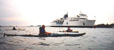
I wasn’t used to carrying three sea kayaks on my car, but since we only had to drive from Owen Sound to Tobermory, we tied them on and headed north. The plan was to catch the ferry from Tobermory to Manitoulin Island on Monday morning and somehow, between fellow kayaker Ron and I, get the three kayaks and all of our gear loaded on the MS Chi-Cheemaun. By not taking the car, we were assured a place on the crossing; plus, we couldn’t leave a car on Manitoulin Island since we would be paddling to a destination on the mainland. The loading went much more smoothly than I had anticipated and we were on our way.
About half an hour into our ferry ride, Ron asked, “Are the waves going to be this large on the other side?” Four-metre waves were rolling in and I gulped as I assured him they shouldn’t be that large. In the ferry’s dining room, seasickness bags were visible on every table…not a good sign.
Our crewmates, Frank and Sam (both Americans, as was Ron), met us at the ferry dock in South Baymouth. The third kayak we had brought with us was for Frank. Our intention upon arrival was to pack up and head east along the southern shore of Manitoulin Island and then north, arriving at Killarney four days later. From Killarney, we would take another four days to eventually arrive at the Key River.
Before we could leave, however, the wind blew stronger and stronger and the sky began to pour. We spent a couple of hours in a coffee shop waiting for the weather to settle. By 4:30 p.m., it stopped raining and we decided to make a start. I wasn’t particularly worried about the waves, especially since Frank had assured me that both Ron and Sam were Class 4 whitewater paddlers and would have no difficulty. Later in the trip, I found this wasn’t quite correct.
“Let’s go!” I shouted. The Chi-Cheemaun had just passed us and we needed to get out of the harbour before it returned. It was necessary to travel in the channel to skirt some large surf waves that were breaking on the shore. In spite of the slow start, it felt good to be on our way after the extensive preparations and arrangements.
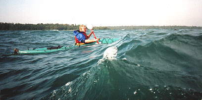
We had to go out a kilometre before we could turn east along the shore. The waves were rolling in at about three to four metres but there were few white caps. After an hour of paddling, I became a little worried when all I could see was surf waves spreading along the shore. I began to picture us having to paddle in the dark in order to get around the southeast end of the island if we couldn’t find a safe place to go to shore. That was not an encouraging idea. Suddenly, I saw a little cove in the distance that didn’t appear to have large surf crashing at the entrance.
“Hey, Sam, it looks like we could make it in there. What do you think?” I hollered.
“Yeah,” yelled Sam. “It looks possible.”
Cautiously, I paddled about a kilometre towards shore. As I approached the shore, I could see a ten-metre passage between two surf waves. Soon I was into the cove and signalled to the others, who seemed to be a long way out. I breathed a sigh of relief when we were all in the cove safely. I was pleased that everyone had done so well and assured them that would probably be the last of waves that large on this trip.
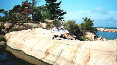
The next day, we had a light wind and headed northwest through the Owen Channel. We passed some interesting rock formations on shore and saw only one other boat all day. We camped near Tamarack Point. The land we were boating beside was a large unceded Indian Reserve and, as such, is private land. Kayakers following this route need to seek permission from the band or risk being asked to leave.
There were thousands of lady bugs along the shore that were more yellow than orange. Apparently they had been imported from Japan to deal with our aphid outbreaks. I learned to be careful about touching them since they bite; one bite I suffered on my neck took a long time to heal.
Another tail wind pushed us along on our third day and we were able to get close to the northeast point of Manitoulin Island. Just before lunch, my rudder cable broke and, with Sam’s help, I was able to make a repair with some spare wire that I had carried for four years… it had finally come in handy! First we tried hitting the fitting with a rock in an attempt to bend it closed. When it shattered, I knew we were going to have to devise another way of attaching the cable. We finally solved the situation by putting a knot in the cable then using duct tape and a piece of wire. I was glad to have a successful temporary repair… I had paddled for over an hour with a side wind angling from the rear, and a rudder is most useful in saving energy from constantly having to correct with sweeps.
I spoke with two native fishermen. “Are you lost?” they inquired as they manoeuvred alongside.
“No, I’m just heading for Killarney,” I replied.
“Wow! Well, have a nice trip,” they said and, after pointing out a fire far in the distance on Fitzwilliam Island, they roared away.
Our largest crossing was Smith Bay, which was about eight kilometres. Since we had a nice light west wind, we crossed it easily in the late afternoon. We camped on a small island close to Big Burnt Island and rolled into bed feeling tired from having paddled thirty-eight kilometres that day. I believed we were in a good position to arrive in Killarney by noon the next day and felt pleased.
“This fish is really great!” exclaimed Sam the next day, as we devoured our lunch at a restaurant in Killarney.
We met a fellow at the restaurant who had flown all the way from Muskoka just for a Georgian Bay fish and chip lunch! Leaving the restaurant, I spotted Bill Pitfield, my Killarney friend and owner of the general store. I told him I didn’t have time to stop and visit as we were on our way to the Fox Islands. Little did I know that fate would have me back in Killarney the very next day. Fully fed, we headed out of the Killarney Channel.
About a kilometre from Killarney, we encountered some three-metre waves by the lighthouse, but we were now veterans.
Suddenly, Sam, with a distressed look on his face, yelled out, “I need to get to shore fast. Those fish and chips are heading right through!”
We paddled into the nearest cove. Sam sprinted ahead and I waited for Frank and Ron and waved them in. I spotted Ron on a surf wave and the next second he was over. I yelled “Rescue!” then “Are you okay? Grab hold of your boat.”
After making sure that Ron was okay, I raced around and grabbed various articles that had been loose in his boat so that he wouldn’t lose them. We then assisted him back in his boat and did the pump-out. Ron was somewhat shaken up and seemed to be rather discouraged. I was thankful this had not happened off a shoal where waves were breaking and rescue would have been difficult. Meanwhile, Sam was still on shore, but I was sure that he had seen us.
We took Ron around a little point in the cove to empty his boat and get him into some dry, warm clothes. Although Ron’s kayak was new, the back hatch was significantly leaking.
“I think I’ll go and let Sam know where we are,” said Frank.
“Good idea,” I answered.
Frank returned ten minutes later. “He’s gone!” he yelled as he approached us.
I looked at him with disbelief. “How can he be gone? I told him we would wait for him.”
This really sucks, I thought to myself. As trip leader, I had given the talk about staying together and keeping everyone informed if we were going to paddle away from the group. I hoped that Sam would turn around and come back when he realized we hadn’t left.
We continued to paddle east, looking along the shore for any sign of him. When we didn’t see him, I was sure that we would find him at the tip of Phillip Edward Island, as that is where I told him we would stop and decide on an inner or outer route. When we arrived at the island, we anxiously looked within a kilometre radius but he was not there. Bewildered, we made camp and spent a lot of time discussing where he could be and how we were going to find him. Ron wanted to report him to the Coast Guard as missing. However, since darkness was nearly upon us and knowing that Sam was a good kayaker, we decided to wait until morning to notify the authorities. I had a sleepless night as I just couldn’t figure out what had happened to Sam.
In the morning, Frank and I decided to paddle the seven kilometres back to Killarney to organize a search. We left Ron camped on the island in case we had somehow passed Sam and he came looking for us. Also, the wind was getting up and Ron was much happier staying back at camp even though we said we might not return until the next day.
I searched along the shore while Frank paddled further out. By the time I rounded the lighthouse point, the waves were four or five metres high and Frank wasn’t in sight. Finally he appeared, really enjoying the power of the water.
In Killarney, I phoned my friend Bill Pitfield to explain our predicament and then phoned the police to report Sam missing. Since I was talking to a dispatcher in North Bay, it took quite a while to relay all the particulars of Sam’s disappearance. Just as I was going to hang up, I heard Frank call, “He’s here!”
I cancelled the report and breathed a sigh of relief.
Apparently, when Sam didn’t see us, he had assumed we had left the cove and all he had to do was to go really fast to catch up. He also claimed he went past Phillip Edward Island because he didn’t have a map and thus wasn’t sure where the island was. The only reason he returned to Killarney was because he didn’t have a map; otherwise, he would have kept going.
I was so mad that I wished I were on a solo trip!
Bill Pitfield agreed to shuttle us to the Chikanishing Creek put-in so that we could get back to Ron as soon as possible… plus, the waves were now huge in the channel. Before we left Killarney, we of course tucked into another fish and chip dinner (actually, it was breakfast for both Frank and me).
During the shuttle, the rain came down in buckets and Frank and Sam got soaked holding the boats in the back of the truck. I felt sorry for Frank but thought a little rain wouldn’t hurt Sam at all.
We thanked Bill, then paddled out into the lee of Philip Edward Island. Ron was surprised to see us back so soon and was very happy to see Sam. I made sure I stayed a safe distance away from Sam when he was recounting his story to Ron, as I knew it would just make me mad all over again.
Soon we were on our way east along Collins Inlet, and by seven that evening had found an island in Beaverstone Bay on which to camp. We had paddled twenty-two kilometres in four hours.
“Let’s pick a site with a good breeze,” I commented. “It’s weird that there are so many mosquitoes in September.” We decided it might have something to do with the dry hot summer that we had just experienced and the rain that had fallen at the end of August.
The next morning we left the campsite about 10:30 and stopped just west of Point Grondine. The wind was starting to blow and Ron was feeling uneasy in the waves. We had some lunch and decided to take the afternoon off as we all needed a rest and a chance to explore and just relax. Fortunately, I moved my tent out of the wind before a large gale came up in the night.
“What do you think about leaving before breakfast?” I asked the group that evening. Agreeable to this suggestion, we left before 8:00 a.m. the next morning and arrived at the Bustards before noon. I was impressed with the beauty and ruggedness of the Bustards and felt lucky that we didn’t have to share this stunning location with other groups. We camped near the south end of the islands. Unfortunately, the wind swung to the southwest and we discovered we weren’t sheltered enough that night. A storm rolled in and at times I thought my tent might take off with me in it. Sam had to abandon his tent at 5:00 a.m. when part of it collapsed.
Reading the Map
By September 10 we had been out for one week. It had been a trip full of both ups and downs and I was keeping my fingers crossed that the remaining two days would go smoothly. After lunch, we paddled to the north end of the islands. The sky turned dark and was alive with amazing cloud formations. We expected to see a tornado at any time. A formidable thunderstorm moved along above the mainland while we watched, just on its edge. I was glad we weren’t out paddling as the wind roared and the rain poured down. Eventually the storm lifted and we set off for the vicinity of Deadman’s Island.
I found out the hard way what “Teva toe” was. As I waded into the water with my boat, my foot slipped on a rock and my big toe crashed into the rock in front. I had torn my nail off and did it ever hurt! “Ow, ow, ouch”! I howled as I flopped into my boat in pain. I tried to think about something else.
We had to avoid a number of shoals on the way. At dusk, an inspiring sunset lit up the horizon. Even though my toe was throbbing, I still thought it was stupendous. We ate supper in the dark, knowing the next day would be clear sailing.
On Tuesday, September 11, we left before 8:00 a.m. and arrived at the mouth of the Key River within an hour. We had coffee at the store and just as we were leaving, the unthinkable happened: the United States was attacked by terrorists. What a shock for my three American friends. All they could think of was contacting their families and getting home to them as soon as possible. While all four of us will remember the beauty of our kayaking adventure, the memory will, unfortunately, always be clouded by the tragedy that happened that awful day in the United States.
By noon, we had paddled to the highway. Joan and Jim, our shuttle drivers, were standing on the dock as we arrived and informed us that we were one minute late! We quickly loaded our gear and headed down the highway.
It was difficult to celebrate our trip with news of the tragedy coming over the airwaves. Still, we all returned safe and sound and all of us had learned to respect Georgian Bay and to marvel at its beauty.