
David Whyte
Michipicoten Island lies in the northeast corner of Lake Superior, approximately 67 kilometres west of Wawa and about 14 kilometres south of an uninhabited stretch of Lake Superior’s north coast. The island has a total circumference of about 65 kilometres, excluding bays and inlets. It contains approximately 30 remote lakes, and is both rugged and heavily wooded.
Ojibwey legends about Michipicoten spoke of giant lynxes that hunted rabbits the size of wolves. A large unfriendly spirit is supposed to have pursued and killed those few Ojibwey who dared to land there, while off-shore waters were reputed to be inhabited by the “Memogovissioois,” malevolent demons that lived underwater like fish. Subsequent attempts by Europeans to exploit the island’s mineral resources (copper and silver) met with failure and financial ruin. At least three abandoned mines are located on the island’s north side. Lighthouses, shipwrecks, steep cliffs, volcanic rock, wild surf, arctic vegetation and a herd of woodland caribou are added attractions.
My trip took place from July 27 to August 9, 2001. This was a second attempt to reach the island. In the fall of 2000, I waited at Wawa with three companions for four futile days while wind and waves swept the surface of Lake Superior, keeping even the largest fishing tugs in port. During the subsequent winter, the other members of our close knit group used various ingenious methods to excuse themselves from further attempts to reach the island. One succumbed to marriage. Another sold out to the establishment and now works as an investment banker in London England, while the third retired and is therefore much too busy to participate in any paddling adventures. Perhaps the island really is cursed!
Once it became evident that my next attempt to explore Michipicoten would be a solo venture, I realized that a sea kayak would be the vehicle of choice. Given the rugged coastline and the frequent need to drag my vessel single-handed over gravel and boulders, I appreciated the durability (if not the weight) of my 16 ½ foot plastic boat. A few excerpts from my journal follow:
July 27
Arrived at Anderson Fisheries’ dock near Wawa after a 10 hour drive, and immediately began the challenging task of stuffing my kayak with food and gear. My packing technique is similar to that used to charge a muzzle-loading cannon. I drop each small package into the appropriate hatch, then ram it to the far extremity of the bow or stern using the butt end of a spare paddle. Once my bright yellow kayak is stuffed to capacity like a well-constructed banana split, I get some help carrying it onto the L and S, a large, white, steel-hulled tugboat resting businesslike beside the wooden dock, its deck covered over with an imposing but reassuring, wave-proof “turtle” made of steel plating.
As we clear the lighthouse at Perkwakwia Point and move farther out into Michipicoten Bay, I prepare to contend with nausea. The wind is from the southeast at about 30 km/h, and we have an unsheltered crossing of some 54 kilometres to complete. That’s a lot of waves. To my surprise, despite a queasy 5-hour passage, during which fishing nets are hauled in and the live contents sorted and gutted before my very eyes, I manage to retain my light breakfast.
My kayak is unloaded at picturesque Cozens Cove, near Michipicoten’s southeast corner. Steep terraces, cut into the reddish, rounded gravel, give evidence of the lake’s past (and future) violence. The tug wastes no time in pulling out. The crew is eager to get home while the lake permits. No one waves as the L and S powers away from the small beach where I squat alone on the wet gravel with my cold lunch. I’m marooned by choice, in the wild heart of Lake Superior.
In due course, I paddle out of the cove and onto the main lake, rounding the high, barren, eastern headland at a comfortable distance. At suppertime, I pull ashore to make camp in a small bay just west of Bonner Head on the island’s north coast. The lake now lies calm and mirror-like. A few stray ripples glint an irregular rhythm in the lowering sun, before dying with gentle music on the cobbles at my feet. Loons and cormorants coast silently near the shore, and dragonflies dance over sun-warmed boulders, snapping at the few stray mosquitoes. I relax, taking advantage of an arrangement of smooth driftwood, a comfortable easy-chair designed by nature and installed by wind and waves.
July 29
Today, I had planned a brief hike to the site of the old Bonner Mine. How naive! All told, I spend almost five hours in the dense humid bush, slapped, scratched, hung up and disoriented by the verdant under-storey. My pace is limited (sometimes literally) to a slow crawl and I suffer much discomfort from thorns, heat and bugs. I eventually gain the summit of a small hill about 600 metres from the coast and am rewarded with a tantalizing view of the sheer north face of Cuesta Scarp, a prominent cliff about 5 kilometres to the south, deep in the island’s interior. That would be about a two-day journey at my current pace. The anxiety of being alone in dense bush at this remote location begins to weigh heavily on my mind. Break a leg in here and I’ll never be found. I resolve to return to camp, having seen no trace of the old mine, and gradually ceasing to care. Crashing northward though the dense vegetation with all the subtlety of a wounded moose, I am both startled and excited by the sight of a large woodland caribou bounding though a small valley below me. It’s gone before I can even think about my camera.
Back at the coast, a large beaver cuts through the chilly water toward me, like a furry torpedo, before climbing onto a rock and trying to stare me down. Beavers are usually timid, but it appears that the Michipicoten Island variety are downright arrogant.
July 30
Coasting easily westward, I am soon peering up at vertical cliffs about 150 metres high. For the most part, these are not sheer to the water but are set back from the shoreline, so that their bases, lined with a steep talus of shattered rock, are hidden behind a dense ribbon of intervening forest. The tops of the hills, reaching an overall height of about 200 metres above lake level, are also hidden from view by the angle of the cliff. The shoreline is comprised mostly of cobble beaches interspersed with rock outcrops. Round boulders of various hues, including black, ochre and white lie scattered on some beaches like forgotten bowling balls. There are numerous rocky shallows.
Next stop is the site of the old Quebec Mine. This time I am not disappointed. Metal pipes, a large pulley and various other metallic debris are arranged along the shoreline. In the deep gloom and quiet of the adjacent forest, evidence of a large, abandoned industrial enterprise is spread over a number of acres. There are cogs, wheels, flanges, springs, plates, bolts and rusty metal fittings of all shapes, sizes and descriptions. There are bottles, boilers, wooden barrels, tools and the moss-covered stone foundations of a number of former buildings that once housed 150 miners. A grey, deeply weathered head-frame leans crookedly away from the deep, water-filled rectangular outline of the main shaft. Rusted pipes pierce the surface of the black water. Never profitable for it’s unlucky owners, this mine has been dead for over 100 years and even the mounds of the old tailing piles are densely wooded.
August 2
I stop to eat an early lunch at a small peninsula known as “The Junction,” just 3 kilometres beyond West End Light. I’ve turned another corner and am now poised to paddle eastward along Michipicoten’s southern coastline. My eyes wander southward to an archipelago of small islands stretching along the southern horizon and impulsively, I decide to make Green Island my next temporary home. The lure of this distant, isolated hump of green, framed by the open expanse of the lake, is irresistible and outweighs any concern about making the direct, open water crossing of three kilometres. I load up and set out on a course of 120 degrees. As I leave the shelter of the main island, the northwest winds take hold and soon I’m riding a 1.5 metre swell that takes me from behind and shoves my kayak’s bow deep into each trough. It’s an awkward, twisting motion and I’d soon be sick if I wasn’t so busy with the paddle. I pass close to Black Rock, a rugged tooth of sooty basalt, fringed by a welter of wind-tossed foam. Gulls scream and breakers roar as I fly past, hull dropping into each trough with a loud smack, solid spray streaming from the bow with each upward heave. I am a man of war from Nelson’s fleet, or a pirate ship heading for Treasure Island.
I’m pleased to find that the east end of Green Island offers a beautiful, sheltered campsite. In the evening the northwest winds increase in intensity, whipping the lake into a froth of whitecaps, completing the isolation. The sun sets in the west, the moon rises in the east and lighthouses pulse on either horizon. My tent shudders and rocks in the gale, held down by anchors of stone-covered driftwood.
August 3
Up early to a beautiful, calm morning. I decide to continue my exploration of the outer islands. There’s a striking low angle view of the Davieaux Island lighthouse as I pass along that island’s 2-kilometre length. The light stands proudly at the summit of a heavily wooded cliff, like the red topped turret of some medieval castle. A quick scramble up a small embankment yields a view of some red-roofed, white-sided storage buildings, and a large concrete heli-pad. The lighthouse was automated in the 1980s and there’s no one about. It’s eerie. I stroll slowly over to the crosspiece of the large, painted “H” and sit down, eyes skyward (just in case). I run my hands over the pebbly surface, then succumb to an urge to lie face down on the cool cement, like a drunk on a sidewalk. I didn’t get much sleep last night. When I regain consciousness, some members of a small flock of Canada geese are eyeing me nervously from the edge of the pad, honking softly, long necks bobbing and weaving like a field of snakes.
August 4
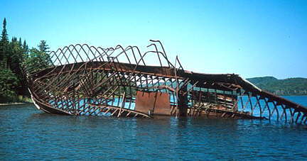
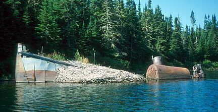
A day spent exploring Quebec Harbour on Michipicoten’s south coast. The harbour was once home to a small but lively fishing community and a place of refuge for fragile paddlewheel steamers making the dangerous run from Sault Ste. Marie to Port Arthur (Thunder Bay), but all that is in the past. Among the more interesting features to be seen are the wrecks of three vessels that lie near the east end of the 3-kilometre long harbour. The remains of the 1902 steam tug Captain Jim lie partly submerged, the bow high and dry, the stern hidden beneath the water. The boiler sits exposed within the hull, looking very much like a rusty old steam locomotive rising from the harbour on invisible rails. A portion of the hull is covered with a large beaver lodge, a visible sign of the tug’s new owners. The Billy Blake lies a few metres further east. About ¾ of her rusting metal framework remains exposed above the water like the skeleton of a beached whale. The 1883 coastal steamer Hiram R. Dixon is the largest but least exposed of the three harbour wrecks. Its resting place is marked on the surface by a line of protruding timbers resembling an old pier, but it is only after gliding over top of its resting place and looking down through about 4 metres of clear water that the true extent of this 45 metre long steamer becomes evident. Timbers, metal sheathing and various fittings of all sizes and descriptions lie scattered on the harbour bottom.
August 5
Tonight the surf is high and waves somehow contrive to crash in on both sides of the gravel bar on which I’m camped. As I lay my head down to sleep, I feel a distinct, regular vibration in the ground like the measured tread of an approaching giant. Wind? Waves? Thunder? Something else? It’s a very lonely night.
August 6
This morning there’s a stiff southwest wind. The shelter offered by Four Mile Point is short-lived and I’m soon sliding and bobbing along in a 1.5 metre swell. The waves are sneaking up from behind, and I nearly twist my head off my shoulders trying to get a glimpse of what’s coming next. Soon the rocks and shoals of Dixon Reef lie before me like a minefield of exploding whitecaps, haystacks and confused seas. The swell builds as I approach the shallows, so I decide to by-pass the whole mess by cutting southward, away from land. It’s sometimes hard for a part-time sailor like me to remember that the safest passage is not always the one closest to the shore. I have to battle my coast-hugging instincts.
I’m soon clear of the reef and starting to anticipate a lazy afternoon on a sandy beach. Suddenly, a heavy fog rolls in and the view around the next small headland is completely obscured. The crash of surf seems to surround me and I’m cut off from my usual frame of reference. I utter a monosyllabic adrenaline-generated expletive (that rhymes with “pit”) and consider my options. I could just bob around in the surf until the mist clears, but I’m back in the high wave zone near the shore and feel quite unstable. I could paddle away from the island and into the mist and attempt to navigate by compass, but paddling on instruments takes a lot of faith and practice, especially in near shore currents, and I don’t much like that option either. For want of a better plan, I let myself drift slowly towards the dimly visible beach, while prying and bracing to keep the kayak upright and perpendicular to the waves. Soon I can see that the shore is composed mostly of rounded boulders as opposed to sharp outcrops. This is relatively good news. The bad news is that the beach is completely exposed, pounded by surf; but I can see a few small rocks near the shore that might offer some scant shelter, so I make up my mind to go on in. In accordance with all the textbooks, I time the landing so that I run aground perpendicular to the beach, just behind a breaking wave. At this point I’m supposed to leap out and drag the kayak (and myself) to safety before the next wave rolls in. Unfortunately my right leg is asleep and the beach is very steep and slippery. I leap out of the cockpit but my leg collapses, so I do a shoulder roll on the boulders. I look up in time to see the next wave crash in. The boat and I both advance up the beach by this means, then I grab onto the front carry handle and dig in, so we don’t get sucked back into the lake. Finally, I crawl gradually upward out of the surf zone, dragging my kayak, leg full of pins and needles. Crash landing accomplished, I sit on the beach for a moment, still firmly encased in my life jacket and neoprene spray skirt, clutching my paddle like the pilot of a wrecked plane still gripping the severed joystick. I soon begin to relax and shed the excess gear, then pop open a hatch in the kayak to grab some food. Come rain, shine, or total immersion, I’m always hungry.
August 8
This evening, the distant rumble of thunder can be heard from the west. It’s a very slow-moving storm if it’s moving at all, and it’s at least another two hours before the first faint pulses of lightning can be seen. I pace the beach restlessly in the deepening twilight, pausing on occasion to watch the sky behind the grey clouds flicker like an old fluorescent light fixture. Suddenly, I’m surprised by a flash and roar from behind. Surrounded! I sprint for the dubious shelter of my small tent as cold, heavy rain begins to fall. About seven hours later, the longest and loudest thunderstorm I have ever experienced is over. It was quite a show. At the peak of the storm, the interior of the tent was regularly lit up as though by a strobe light, lightning flashing at a frequency of about once every five seconds. Since I hid under my sleeping bag where the storm couldn’t see me, I was not harmed.
August 9
In hindsight, this whole day was an anticlimax. The L and S cruised, business-like, into the cove exactly on schedule. My kayak and I were aboard in minutes and then we were off. As we cleared the cove and gulls soared in the wake of the tug, I vowed that some day, some way, I would return to my island and discover the many secrets still locked away in its silent interior. Then, as the East End Lighthouse gradually receded into the horizon, I closed my mind against the assault of four hours of nausea.
Whether due to some special magic of the lake, or just good piloting by Horst Anderson, I again kept my food where it belonged, and the hungry gulls were disappointed. We landed at 4 p.m. Two hamburgers later, I was ready for the long drive home.
If You Go: Potential visitors should be advised that no services of any kind are available on the island, and any itinerary should allow for weather generated delays. Paddling on Lake Superior can be very challenging and the ice cold water leaves little margin for error. While the majority of the island is a non-operating provincial park, portions remain in private ownership. Staff at Lake Superior Provincial Park (705-856-2284) can provide details. A popular method of reaching the island is to charter a fishing tug from Anderson Fisheries (705-856-4835). For those who like to leave travel worries to the experts, guided, fully outfitted paddling tours of Michipicoten Island are offered by Naturally Superior Adventures in Wawa (1-800-203-9092, www.naturallysuperior.com).
Maps: 41N/12 and 41N/13 (1:50,000 Scale)
Recommended Reading: David C. Whyte: An Introduction to Michipicoten Island – Lake Superior’s Wild Heart. Describes the history, biology and physical features of the island and includes photographs, species lists and a list of scenic locations. (This book can be purchased directly from the author: david.whyte1@sympatico.ca.)
David Whyte is an environmental planner based in southern Ontario. This article originally appeared in the Spring 2002 issue of Bushwhacker magazine, and is reprinted with permission.