
GLSKA’S MICHIPICOTEN ISLAND TRIP
by Johanna Wandell
It isn’t likely that you’ll find Pukaskwa pits on Michipicoten Island, nor will you see pictographs. It wasn’t a place the Ojibwe frequented, not only because of its remoteness (the nearest point on the mainland is over 16 kilometres away) but because it was said to be the domain of Mishepeshu. According to the stories, those few Indians who made it there either perished crossing back or very soon after they had visited the island.
Europeans haven’t done much better. According to Chisholm and Gutsche (1999) and Littlejohn and Drew (1975), the Upper Canada, Superior and Quebec Mining Companies, Michipicoten Native Copper and Standard Oil all lost money trying to extract copper from Michipicoten Island from 1846 to the early 20th Century. The Chicago, a 3200-ton cargo ship, and the Strathmore, a 61-metre wooden steamer, met their ends at Michipicoten Island. While the Quebec Harbour fishing station had sustained a modest commercial fishery from 1839 onward, it collapsed during the 1950s when sea lampreys made the Michipicoten Island fishery too marginal to compete with larger operations. The light keeper of the Point Maurepas lighthouse disappeared on his way from the island to the mainland in 1918. His son took over, but lost all of his supplies and buildings to fire in the winter of 1928.
Not even bears bother with Michipicoten Island. While the place is crawling with beavers, fox and caribou (my evidence for this is little more than tracks, though), bears, moose and wolves are absent.
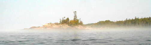
So, given all that, why did we want to go there? For me, it was the mystery of the place. The Indians said it was “a floating island, sometimes far off, sometimes near, according to the winds that push it and drive it in all directions” (Father Dablon, quoted in Littlejohn and Drew). Add to that Native legends which claimed that the island was made of heavy shining yellow sand, gleaming metals and beautiful stones but also the home of giants and gods. A place whose fogs were held to be poisonous vapours, the same fogs that I had seen roll over the island while sitting on a cobble beach in Lake Superior Provincial Park, had to be explored. Never mind that Alexander Henry reported that he “found nothing remarkable” there in 1869 and that Isaac Hope called it “an exceedingly dreary and desolate place” in 1872 (both cited in Littlejohn and Drew), all of this just made me want to see it myself that much more. So, this winter, Michipicoten Island was at the top of my “I want to go there” list.
A glance at some topographic maps shows that Michipicoten Island is uninhabited save a handful of summer cottages and that most of it is crown land (currently, it is classified as a non-operating provincial park). Given its location – more than 15 kilometres of open water crossing to the nearest point of land on the already remote Pukaskwa shoreline – I did not consider it the kind of trip that I could put together myself given my relative level of inexperience and lack of serious paddling skills. So Sam Wyss’ listing of a trip to Michipicoten Island on the GLSKA trips site got me excited, and I e-mailed him and joined GLSKA. Then, on July 12, eight of us – Sam, Peter, Jim, Frank, Bill, Lee, Melissa and I – went to Michipicoten Island.
Sam did all the work for this trip, and it was greatly appreciated. Arrangements had been made for a boat shuttle (Anderson Fisheries, out of Michipicoten Harbour) out to the Island and camping and dinner for the night before (at Naturally Superior Adventures in Michipicoten River). He’d even gone so far as to list the topographic maps required and arrange carpooling for those who wanted it. We met at NSA’s Rock Island base on the evening of July 11, and took care of essentials like loading our boats into the shuttle boat, setting up our tents on their beach, drinking some beer and eating Sam’s rhubarb pie (which looked much more enticing than the bright blue jello dessert which came with the whitefish dinner that we enjoyed at NSA’s lodge!).
We were scheduled to leave at 6 a.m. the next morning, which in Lake Superior East local time translates to about 6:45. For the bulk of that morning, we hung out in the L&S, a fishing vessel that spends a good chunk of its time during the summers shuttling kayakers and canoeists and doing coastguard duty. Well over four hours later, we pulled into Cozens Cove. We landed at a private dock, and were warmly welcomed by the couple who owns the dock. Unloading was a major undertaking – the fully loaded kayaks were lifted out of the boat and lowered into the water, and from there lined to the dock. I heard a few gelcoat cracks there, and I still feel guilty that the guys had to lift my overstuffed yellow plastic boat. But we were really here now, on Michipicoten Island, and once we paddled out of Cozens Cove, we were out of sight of any signs of civilization.
We paddled for less than an hour in calm conditions before we reached the Point Maurepas lighthouse and stopped for lunch. Though there is an assortment of buildings, which are definitely habitable, the light is currently unmanned – maybe a good thing considering the fate of the two lightkeepers I’d read about.
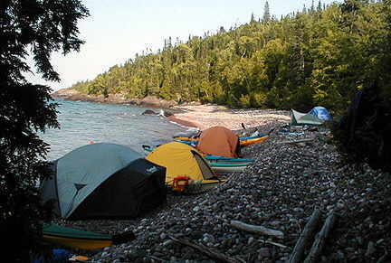
All that we’d heard and read indicated that there were few places to camp on the north side of Michipicoten Island – and what there was is west of Bonner Head and marginal at that. Kurt Anderson – the fisherman in Anderson fisheries – had, however, told us that he thought Bonner Head Beach was large and suitable. It wasn’t the only large and suitable cobble beach we passed, but we fought a 15-knot headwind all the way to this spot before setting up for the night. It was still early, so there was sitting and napping in the sun and consuming some of Peter’s beer before dinner.
We finished the evening off with a campfire and got to know each other a bit better. At one point, I decided to explore a game trail, but gave it up rather quickly. The botanist John Macoun, who travelled with Sir Sanford Fleming in 1872, found Michipicoten Island to be a treasure trove of rare plant species, but all I can tell you is that the brush is really dense, and that the game trails are only three feet high (the average height of a caribou?). Littlejohn and Drew maintain that Michipicoten is a natural wildlife sanctuary, bountiful in caribou, mink, marten, muskrat, silver fox, lynx and beaver. I saw some tracks, but what I can say for certain is that Michipicoten Island breeds wicked biting insects. I did see some beavers torpedoing through the water in the creek that ended on the beach, but that was the extent of my wildlife viewing during my time on the island.
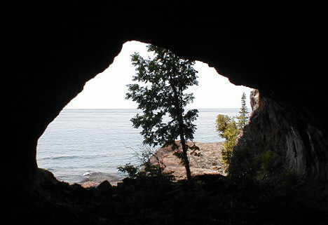
Our first morning on Michipicoten Island, we got up early – some of us not quite as early as others, but we were all on the water well before 8 a.m., leaving lots of time for exploring even if Sam did aim to circumnavigate half of the 24-kilometre long island that day. We stopped at the Quebec Rocks (yet another prime camping spot, nothing marginal about it), where the guys went on a 90-minute bushwhack to find the remains of the unlucky Quebec Mine. Shortly thereafter, we explored a very large sea cave, which apparently was used as a powder magazine for the mine at some point.
After the cave (which would have been another good place to camp, but it’s private property), we made our way around the west side of the island towards our night’s destination, West Sand Bay. Everybody paddled at their own pace, which meant that I, the least experienced kayaker in this group, was far behind – but Jim stayed with me and decided to use the tailwind to try umbrella sailing all the way to West Sand Bay. I’ve since heard from David Whyte, who was on Michipicoten a week after we were there, that the cottagers in Quebec Harbour were still talking about the kayaker who used his umbrella as a sail.
West Sand Bay has a nice sandy beach, but I’m not a big fan of sand for camping. I got over it, though, when I found a perfect piece of plywood for my kitchen farther down the beach, and Peter and I set up our stoves on. My pride in my kitchen was short-lived, however – Lee showed up with a much bigger flat piece of debris for his kitchen. If I had been determined enough, I’m sure that I could have found an even bigger hunk of debris here, since Superior has washed up all kinds of junk on these southwest-facing beaches.
Once again, we had a campfire on the beach (which was covered in fox tracks, Sam figured there was a den nearby), but turned in early because, above all, Michipicoten Island is a bug sanctuary (and since they don’t have large mammals like moose and bear to feed on, we must have seemed like the tastiest game going). The bugs definitely hadn’t got tired of the game by the next morning, either, making it that much more appealing for us to be packed and on the water before 8 a.m. again.
Just as we launched at West Sand Bay, Lee’s rudder cable snapped. This of course guaranteed that we’d have following winds, which, though probably unpleasant for the now rudderless Lee, were prime conditions for Jim’s umbrella sailing endeavours. We stopped to explore Quebec Harbour, which contains a few private cottages, an old townsite (“No Trespassing” signs on that one) and the half-submerged wrecks of the Billy Blake and Captain Jim.

After Quebec Harbour, the winds really picked up, and Jim almost kept up with my (5.5-6 km/h) paddling pace with his umbrella. The rest of the group waited for us in a sheltered bay behind Four Mile Point, which is where the handle of Jim’s umbrella came off and he lost it, and he decided to don his wetsuit to go diving for it. Melissa, Lee and I paddled on ahead to East Sand Bay during this operation, and we all reconvened for lunch there. Jim and Lee then fixed the broken rudder cable using nothing more than a stick of gum and some cellotape (ok, a multitool and a rusty piece of wire), and we rode the ever-increasing rollers toward Point Maurepas and completed our circumnavigation of the island.
Funny thing – the winds were from the southwest, but once we rounded Maurepas and were on the northeast side of the island, we were nonetheless faced with a stiff headwind. Our original plan had been to return to the Bonner Head area, since that is the closest point to cross to the mainland, but we ended up stopping for a wind break on the first cobble beach past Maurepas, and Sam was prevailed upon to call it a day. I was happy with this decision, since the morning would bring our big open crossing to the mainland and I didn’t want to wake up exhausted from fighting the wind the day before.
My GPS showed 21.8 kilometres to Ganley Harbour, our destination on the mainland. So, for a change, Sam changed the 8 a.m. start time to 6 a.m. (of course, I wondered if that meant we’d be on the water by five, given the early rising nature of this group!). We were fortunate with ideal conditions – flat, glassy water with no fog for the entire 3 hours and 45 minutes it took us to make the crossing, but to be on the safe side we were decked out in wetsuits. We stopped for a break 9 kilometres from Ganley Harbour, but overall I was pleased with my just slightly less than 7 km/h speed (since I am the slowest, my speed dictated the pace this time).
We paddled into Ganley Harbour, and then into False Ganley Harbour for breakfast (the guidebooks list False Ganley Harbour as a campsite – but it’s nothing more than a narrow sand beach, and not a place I’d seek out for an overnight. But then, these are the same books that say campsites are scarce on Michipicoten). I was struck by the beauty of the scenery – the Island had remoteness and mystery going for it, but the mainland boasts towering cliffs, dazzling beaches and rocky outcrops. Looking back across the water, Michipicoten Island seemed very far away indeed, and when you compare the Island’s scenery to the mainland, Hope’s “desolate and dreary” description becomes understandable.
Over breakfast, Peter and Sam discussed further travel plans while I finished off the contents of Peter’s coffeepot. Peter, Jim and Melissa had travelled this coast before, and Peter has a good memory for nice sites. It was tentatively decided that we’d shoot for the mouth of the Pukaskwa River in Pukaskwa National Park – a distance of a further 16 or so kilometres. From there, Cascade Falls would be within striking distance. Sam really wanted to make it to Cascade since that would complete his exploration of the coast from Silver Islet to Michipicoten Harbour. We had a lunch break at the Wheat Bin, an immense white sand beach, and made it to the Pukaskwa River by early afternoon.
The Pukaskwa River site is nothing less than gorgeous – it sits in the middle of an immense playground of stuff to do. The bay and river mouth are configured in such a way that there is interesting surf no matter how calm the lake, and this made for fun swimming (Jim played in the surf in his kayak). Schist Falls, less than a kilometre upstream from our site, appears to be a popular destination – that afternoon, a huge luxury cruise boat anchored off our site and dropped off several launches of tourists who engaged in mothership hiking. I checked the falls out after dinner and managed to find the trail, but resolved to return the next day for further exploration.
Peter and Sam left at 7 a.m. the next morning for a tough day’s paddle to Cascade Falls and back. Me, I got up at 7 a.m., but I did nothing more than read my book and drink several cups of coffee (not paddling meant I didn’t have to limit my diuretic intake either). Frank and Lee (exhausted from a night of battling the local wildlife) slept in, Jim and Bill helped me take apart my stove to do some much-needed maintenance (I had to unclog the jet, and I cleaned the fuel line while I was at it). We all lounged around until noon and chatted with a pair of canoeists who stopped by.
While Peter and Sam saw Cascade Falls and discovered a motherlode of vision pits, the rest of us followed our various leisure-day pursuits: Melissa went for an exploratory paddle, Bill decided to go fishing, and the rest of us departed for the trail at Schist Falls. We made it to the very end, above the next set of falls beyond Schist Falls. Back at the base of the falls, Jim donned his diving mask to look at the pools from below while Lee and I worked our way up the canyon using a combination of swimming, scrambling and a log thrown across a rapid. Thomas Anderson described the falls in 1849, noting “the most beautiful spoon shaped basin to the falls, which come tumbling down a tremendous chasm in the rocks. It hastens down with the wildest speed conceivable, as if to escape the over hanging precipice on either side – immense rocks have fallen into it from the height, against which, in its furious progress to the placid basin below, it dashes head-long throwing its spray all around and creating rainbows innumerable” (quoted in Littlejohn and Drew). What he said. Sitting on a huge boulder in the midst of rushing whitewater at what I figure is the point on Superior furthest removed from any roads was as good as it can get, I thought.
But then it got better. Melissa told me that the next cove to the north (Imogene Cove) was beautiful, and let me borrow her map (my topos didn’t go this far), and Lee and I went for a very leisurely exploratory paddle during which we saw Sam and Peter return from Cascade Falls. We turned back just short of Point la Canadienne, and got back to the site to the smell of brownies in Melissa’s Outback Oven! Just as good, Bill had caught an enormous lake trout, and was frying up fish to share! I dug through my food bags and came up with a red cabbage to turn into a salad, and appetizers (smoked oysters on crackers) magically appeared, and we enjoyed a fantastic dinner and campfire.
Despite bearanoia, I slept well – which was good, since we were back to Sam’s usual “I thought we’d leave by 8 o’clock.” Sam, Bill, Melissa and Lee had further wildlife visits which I slept through (to his great disappointment, Jim did as well – he had worked out the rules for a game of porcuquidditch, an elaborate wilderness activity which involves 30 second periods during which opposing teams try to herd porcupines to the other team’s tents).
After the Pukaskwa River, we headed east – toward our takeout point at Anderson Fisheries. We once again stopped for a break at False Ganley Harbour, and Sam decided that we’d make Floating Heart Bay our next home (giving us a moderate 28-kilometre day). Once we got to Floating Heart, however, the canoeists who had stopped by our Pukaskwa River site were already there – but Sam had spotted a nice spot for his tent in the shade on the opposite end of the (large) beach from them, so we stayed despite moderate feelings of guilt at horning in on another party’s site.
We hit hot weather that afternoon – the sun was relentless. Sam disappeared into his tent for a long nap, Jim and Melissa embarked on an exploration of another creek. (Jim would like it known that he cliff-dived and butt-dammed a stream, though not in the buff in deference to the other member in his party.) While Lee demonstrated his proficiency at the roll, I cleaned out my kayak in the water, and then borrowed his paddle float to see if I could self-rescue in deep water (proud to report that I can). After that, I decided to clean out my dry-bags while I was at it, and then hung out in the best kitchen yet: a rock table, two log benches, a log to hang the bucket for water filtering. Up until this point in the trip, Sam had always had the best kitchen, but the rest of us are no dummies: we finally learned, and started scouting for good locations early as well.
The winds kicked up overnight and the other parties on the beach (we had been joined by a couple of guys in kayaks later that evening) decided not to travel in the morning. We did (at, yes indeed, 8 a.m.), and even though it was high-output paddling, I had a great time working my way through the bigger water (and felt very secure since two of the guys paddled with me and I knew that even if I did go over, there were competent rescuers around). However, it wasn’t the speediest way to travel, and by 10:57 we had covered only 8 km and decided to take a long break at The Flats, a gorgeous site that resembles paradise even if it is full of sand that got into my freshly cleaned out boat.
By 1:00, the winds had died down enough that we decided to press on past Point Isacor, a stretch notorious for reflection waves and its lack of suitable landing spots. It had become hot and my 6.5-7 km/h paddling pace was slower than the rest of the group’s, but I made up some time by cutting across all the bays while the rest of them explored the shoreline. The last five kilometres were tough going – I was hot and tired – and I enviously looked over at Jim sailing with his umbrella beside me (of course, I would have been way too chicken to try and sail myself even if I did have an umbrella). Jim’s comment as I was making notes in my journal that night: “You may note that I successfully sailed the last five kilometres and I successfully negotiated the harbour including the rapids at the mouth, and I didn’t lose the umbrella either.”
I don’t know about the rest of them, but I was wiped when I got to the site at the mouth of the Dog/University River – and then I partook in happy hour. For the rest of the evening, I was capable of little more than staring out at Superior like it was tv. I didn’t feel the need to explore, either, since over happy hour we’d decided on a plan that would allow us to spend our last night here as well, leaving a full day to explore the river and Dennison Falls.
Let it be noted that, for the first time on one of his trips, Sam Wyss had a day where nobody, not even Sam himself, paddled a single stroke. All eight of us trooped into the bush at 9:30 the next morning to find the trail to Denison Falls. We stopped for a group shot at the sign declaring the river to be the “Dog River since 1763” (maps sometimes show it as the University River, but you’ll have to ask Jim to get the full story here). The trail looked like it would be the toughest portage in the history of portaging, including a rope hanging over a small cliff which was designed to lower canoes. I had no canoe on my head, and I found this place challenging.
Tough, but oh so worth it! We got there, and I thought at first that it was raining because the spray from the falls was so big. After a few minutes of mute staring at the 40-metre waterfalls, we decided to scramble to the top (there is an easy scrambling route on river left along the falls). Every view was more impressive than the last. The place was doubly special since the ruggedness of the trail precluded the mothership type hikers we had encountered at Schist Falls – this one involved getting sweaty, bug-bitten and scratched.
We had lunch high up on the rocks at the top of the falls. Sam’s comment here perfectly summed up Denison Falls: “Niagara is boring.” After lunch, our group split up – all but three of us returned to the site. We made our way up a side stream and were rewarded with many small cascades along the way, and Jim even stopped and had a shower in one of them. We followed this up with a swim in a standing wave farther downstream on the Dog River. Fun! We worked our way into the top part of the rapid, then let go of whatever rock we were clinging to, and the swift carried us a good 30 metres downstream. My comment after the first time was simply “again” and I took the ride no less than six times.
Meanwhile, back at the site, Bill was fishing – and he caught some northern pike for our dinner. Several of us threw together our supplies, and we ended up with appetizers of mackerel on crackers, a main course of fried fish, rice, cabbage salad and bacon, and dessert consisting of hot chocolate with brandy. Our last night’s dinner was miles better than the fish dinner we had the first night at NSA, even if Sam neglected to bring a pie this time.
The weather forecast for the next morning did not sound promising – 25-knot side winds were called for, and we had over 20 kilometres to paddle. We decided to leave at 7 a.m. and take breaks as we needed them, but it turned out to be a perfect paddling day with virtually no waves. We stopped for a at a little jewel of a beach at Minnekona Point. We then made a run for the last point – or rather, Lee and Sam raced for the last point, with Sam edging Lee out narrowly. (Jim’s comment: “old age and treachery beat out youth and strength.”) I once again brought up the rear with Jim keeping me company (we managed to figure out what cross-track error meant on my GPS along the way) and by noon we hit the beach at the Anderson’s and our adventure was officially over.
The Superior shore from Point la Canadienne to Michipicoten Harbour is eye candy. The travellers of the 18th and 19th Centuries were apparently not enamoured of it, complaining that it was nothing more than “rocks and pines, rocks and pines!” and “terrible because of a chain of rocks and mountains” (Littlejohn and Drew). Rocks and pines and shining sand beaches and inviting cobble beaches and gravel bars and points and islands and bays and cliffs and waterfalls… that’s why I was here. While the explorers considered the shore to be the most desolate on the lake, I found the stretch from Pukaskwa River to Perkwakia Point to be one of the most special places I’ve been to yet. But then, Superior is special.
References:
Chisholm, Barbara and Andrea Gutsche. Superior: Under the Shadow of the Gods. Toronto: Lynx Images, 1999.
Littlejohn, Bruce and Wayland Drew. Superior: The Haunted Shore. Toronto: Gage, 1975.
A more informal look at the trip, including more pictures, can be found at Johanna’s web-site: http://johanna.wandel.ca/michipicoten/tripreport.htm .