by Wendy Killoran
I’d arrived on Manitoulin Island’s shore with a great sense of mystery. The world’s largest freshwater island is situated at the northern tip of Lake Huron. As I paddled counterclockwise around its convoluted coastline with my paddling companion Michael, a natural paradise of spiritual presence, mystical wonders and magical moments revealed itself.
The ferry ride on the Chi-Cheemaun, Ojibway for big canoe, from Tobermory had us huddled in several warm layers in the lee of the northwest wind. Incessantly, the wind howled as an onslaught of waves sped eastwards. Would the Great Manitou appease the wind and allow us safe passage? After all, the fetch was considerable considering that Lake Huron is considered to be the fourth largest lake in the world by surface area (63,500 km2).
Upon our arrival at South Baymouth, we found a sheltered sandy bay in South Bay, a long, narrow bay bordering the Wikwemikong Unceded Indian Reserve.
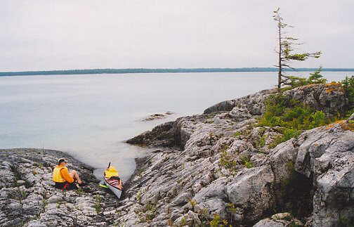
In fading light, we departed, excited to experience this natural paradise. We paddled only briefly in huge waves rolling from the northwest, three metres in height, pushing us eastwards to Thomas Point. The exhilaration of the water’s powerful waves and the cool, gusting wind revived my senses instantly. We’d both finished another year of teaching. It was essential that we renewed our spirits immersed in Manitoulin’s Nature. We ducked into a sheltered bay and pulled our heavily laden kayaks onto a limestone pavement of flat bedrock covered in polka dots, dissolution marks. Our circumnavigation had begun. We were away from the hustle and bustle of busy schedules. We would immerse ourselves in the land of the Great Manitou, the native spirit of Great Miracles responsible for creation.
Manitou combines the meanings of spirit, mystery, and magic. How would the Great Manitou manifest its power and supreme spirit upon us? Native American cultural and religious beliefs have always encompassed values that spiritually connect with Nature. In our own way, we would make our personal connections in the land of the Great Manitou. We would feel the light and heat of the sun, witness the growth and healing of the earth, revel in the purity and renewal of the water and feel the music and breath of life itself in the wind, the four substances created by the Gitche Manitou.
Departing from Thomas Point, we had a forceful tailwind that had us in enormous waves, rolling eastwards, to Hungerford Point at the southeastern tip of Manitoulin Island. The Great Manitou was welcoming us with helpful winds. We surged gleefully along. It was thrilling to be on such huge waves on such an expansive lake. I lived for the moment. I focused on the water. I felt the raw energy surrounding me as the lake flowed and pushed us into Owen Channel with great vigor.
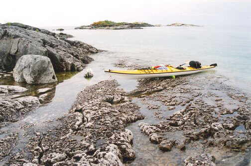
Waves curled around the tip but diminished considerably in size. We made good distance with such favourable conditions. Lush forests clad the limestone interior, mainly cedars, birches, and evergreens. White limestone fringed the shore; boulders, pebbles, tabular shelves, or small cliffs. The sun shone intensely, and the turquoise hues of the clear, cold water dazzled us with their extreme clarity.
We lunched on a gravel beach, drenched in sunshine. Again, we rested just north of Tamarack Point, another raised pebble beach created from glacial retreat when water levels were considerably higher. We lounged in the warm sun. We were alone in Nature, not having seen anyone all day. The shore was wild and beautiful.
We continued to paddle northwards along the eastern shore of Manitoulin Island, with a moderate tailwind. The sun was sinking towards the cliff on our port beam. Try as we might, only huge boulder beaches presented themselves, all very inhospitable landing sites. We were feeling the fatigue and were ready to go ashore and wondered out loud if the Manitou would provide us with a suitable campsite. Magically, within a few minutes, a sandy sheltered beach appeared just South of Hornburgh Point. Could the Great Manitou hear our thoughts?
The sun quickly dipped below the cliffs bordering the raised beach. The ubiquitous poison ivy created a barricade to keep us hugging Manitoulin’s shore.
The following morning, we discovered that we were camped beside a ripe patch of wild, bountiful strawberries. Manitoulin Island was showing us its benign and beautiful character. Another glorious day unfolded. I could feel the spiritual presence in the calm, warm wind, the clear gentle water, the heat of the summer sun and the beauty of the land. Could the Great Manitou cast an enchanting spell? We were captivated. The journey had been so incredible, in every aspect, and this would continue throughout the duration of our circumnavigation. Did the Great Manitou’s presence really look upon us? Were we welcomed because we’d dreamt of paddling here? After all, the Great Manitou had created man with the greatest gift, the power to dream.
We paddled across a calm James Bay. A scree covered cliff towered to our west as we headed northwards, with a grey undulating horizon, the stunning La Cloche mountains found on the mainland at Killarney Provincial Park.
Briefly, in a sheltered, sandy bay at Cape Smith, we lunched. An expansive blue sky with picture postcard cumulus clouds stretched above us. On calm water, we traversed Smith Bay, and paddled amongst an archipelago of small, low islands near Manitoulin’s northeastern extremity. At one small island, a startled carp torpedoed away from our kayaks. It had been oblivious to our approach in the shallow water where it rested. On the crossing, a royal red damselfly had first landed on my waterproof map case and then on Michael’s kayak. Could the Manitou disguise himself?
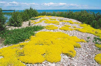
And then, a small island fringed by a pebble beach and low shrubbery revealed a natural treasure. Upon closer inspection we found a lush carpet of puffy voluminous bunches of brilliant yellow stone crop. Within the centres of these flowers were speckled brown tern eggs which also were camouflaged in small rocky depressions. We were excited but felt reverence. It was a magical place. Dozens of terns screeched and circled above. We departed, having witnessed the spirit of life in all its beauty.
We ventured into the North Channel, passing between Partridge Island and Center Island to Creak Island. Here a quartzite cliff plunged into a narrow channel known as Hole in the Wall. A strong southwest wind had arisen. We’d found a sheltered grassy meadow adjacent to polished white quartzite, artistically painted by orange and grey lichens. The sunset was a nondescript departure of the sun, fizzling into a grey bank of clouds.
The following morning another sunny day greeted us, as well as strong westerly winds. The Manitou would test and challenge us! We plodded with vigour. I needed to keep my mind occupied with the journey. I was overcoming a challenging year emotionally. People who I’d believed were my friends were not. It had hurt when I realized how shallow, insincere and deceitful some people could be. The healing power from Nature seeped into me.
Heywood Island magically presented us with a much-needed gift. Incredibly, we found a neon lime green pool noodle, which we cut in half, to use as a roller for the hulls of our kayaks on the unforgiving limestone shoreline. We also had lunch on a sandy beach of exquisite beauty – a garden of stonecrop dappled the sheltered, sandy shore. Wood lilies and blue harebells festooned the meadow rimming the bay.
We slogged into a relentless westerly wind, making slow progress as our bows slammed into trough after trough. Cold water sprayed my arms and once splashed down my PFD, making me shiver.
In the lee of Strawberry Island, we took a break and found massive concentric circular fossils, which I presumed were stromatolites, fossilized algal mats.
Rounding the northern tip of Strawberry Island, we inched forward to Little Current. As we passed under Canada’s largest swing bridge, we dug in. A strong current flowed against us. The entire town was rimmed with steep walls along the embankment, suitable for large boats. The shoreline was not at all kayak friendly. We replenished our food supply and headed to a nearby island where we explored a ruined sawmill.
At the crack of dawn we awoke. I realized that the hushed silence meant that the wind had died down. We launched as the sun peeked over the horizon, on a glassy North Channel.
As we approached Wabos Island, I wondered if the Great Manitou had played a trick on us. The wind had suddenly charged at us like a sprinter bolting out of the starting blocks. We barely crept forward. It was exhausting. At Wabos Island, we rested. We spent the afternoon exploring the perimeter of the small island, discovering numerous fossils.
The wind blew continuously and we camped on a sheltered raised beach. The following day the wind continued but we decided to venture westwards. It seemed that it had diminished somewhat, and we were eager to continue our progress.
It was Canada Day. I remember spending the day crossing bays into high wind and progress-impeding waves. My energy drained from these crossings from the blustery conditions. Had we somehow angered the Great Manitou? We had predicted that the numerous deeply indented bays would shelter us from prevailing winds, but relentlessly, we faced an onslaught of headwind and waves.
Rounding Maple Point, large swells three metres in height paraded from the northwest across the North Channel. This shore was quite exposed to the prevailing conditions. I was feeling the fatigue, and so was Michael. Often, he completely disappeared out of sight in a trough that completely swallowed him up. Not even his paddle tip was visible.
At Jessie Point, we found a sheltered beach. My landing was not as graceful as usual, with a wave unfurling a wet welcome in my cockpit. A sandy beach with raised stone terraces and rimmed by verdant cedar trees made a fine campsite. A giant log made the perfect kitchen. As soon as the sun set however, a voracious buzzing army of mosquitoes encouraged us to retreat for the evening.
Amazingly yet again, another glorious day of sunshine greeted us. We hugged the shoreline and paddled in calm, clear water. The leviathan waves from the previous evening had completely vanished. The Niagara Escarpment was visibly prominent as we entered Gore Bay to stop at the town of Gore Bay. Here we indulged in a delectable ginger ice cream at the “Island Pantry,” a quaint health food store which was like stepping back in time. The walls were covered with shelves stocked with glass jars filled with pastas, herbs, flours, and beans.
Back on the water, a complete calm ensued. The Great Manitou whispered its magical presence all day long. Following Janet Head lighthouse, we paddled across Julia Bay, where perfect mirror reflections, infused with saturated colours, reflected off the water.
On Barrie Island, at a lengthy, curving sand and pebble beach along Blackstock Bay, we feasted on a gourmet lunch. This day was idyllic. The paddling seemed effortless. The weather was real summer weather, and the scenery continued to impress us.
We paddled across Bayfield Sound, another calm crossing, where the sun sparkled in a blinding white, diverging trail, shimmering enchantingly. At Cape Roberts, we pulled ashore on the western tip along an expansive, sweeping pebble beach covered with horn shaped rugose corals from the Paleozoic era, lying loose amongst the pebbles. The entire shoreline of Manitoulin Island is covered in fossils of corals and invertebrates, evidence of a previous warm inland sea.
An unspectacular sunset was followed by yet again a calm, gentle morning, filled with warm sunshine. We were indeed blessed, in many ways. We wove past several small islands. At Shignaconi Bay, we heard a loud scream. We weren’t sure what to think. We noticed a cabin tucked into the depth of the bay, part of the Sheshigwaning Indian Reserve. A large cairn climbed out of the shallow bay, indicating a hazardous area for boats, but our kayaks have such a shallow draft that we could cross the shallow bay easily. We lunched on Vidal Island, having rolled our kayaks on a shelf of gently sloping limestone. Faults in the rock are perfectly straight and can extend for several hundred metres. The topography of the lake bottom was always clearly visible tens of metres deep with such unrivalled clarity.
At Batture Island, we discovered a gull and cormorant rookery. Putrid guano aroma accosted our sense of smell in the heat of the mid day sun. A raucous, non-stop cacophony emanated from densely populated colonies. Swirling aerial activity filled the cerulean sky. We were surprised to find huge piles of straw built into high rise nests by the cormorants, which seem to tolerate and share rocky islets with nesting gulls.
The benign weather encouraged us to continue paddling across a calm Meldrum Bay and around Meldrum Point into Mississagi Strait, a passage of water separating Cockburn Island from Manitoulin Island. Kilometres of forested shoreline and rocky beach crept by. Manitoulin’s splendor seeped deep into my soul. A few fishermen trolled along the shore. Just north of the huge limestone quarry, operated by Lafarge, we pulled ashore. We were eager to bathe in the warm sunshine, to wash away a week’s worth of toil and sweat. It seemed to draw the parade of fishermen in close to shore once we braved the chilly water.
All night long, a distant drone and trucks beeping could be heard. The next morning, we discovered our proximity to the quarry as we paddled past a docked Great Lakes freighter, whose bowels were being filled with the quarried limestone.
The Mississagi lighthouse provided an enjoyable respite from the pouring rain as it now welcomed tourists who ventured to the remote western extremity of the island. It had been converted into a restaurant and souvenir shop.
In a downpour, on a placid, brooding grey lake, we rounded the southwestern tip of Manitoulin Island. It was refreshing to feel the rain drip down my face. We were now on the wide-open lake again. This southern shore slants in long, flat shelves of limestone into Lake Huron. A slight variation in water level dramatically changes the shoreline. The limestone slants up to the Niagara Escarpment, which rims the northern and eastern edges of Manitoulin Island.
Soon a wind picked up, a formidable headwind. We bent into the wind and paddled through island groups. At Steevens Island, we saw a bald eagle and its massive twig nest in a towering, nude tree that reached above the forest’s canopy. The wind became a factor, and progress slowed. Near Belanger Point, a fog settled around us. Navigation became tricky, as what appeared was different from what was indicated on the map, due to fluctuating water levels, which were considerably higher when the map was produced many years ago. Bays had disappeared altogether, and islands were more numerous and larger.
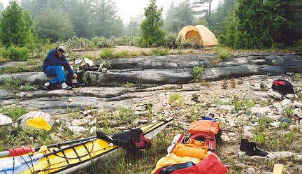
Eventually, riding a southern swell that rocked the kayaks playfully, we entered Burnt Island Harbour. In a mystical fog, punctuated by golden light breaking through, we found a sandy beach backed by flat rocks surrounded by lush cedars. It was a beautiful cove.
We explored the flat rock that was polished smooth from glacial scouring over 10000 years ago, with perfectly straight striations gouged into the surface. A rusted tricycle lay abandoned on its side. I imagined a child spending hours riding over this flat rock.
As evening approached, I’d thought silently to myself how I’d never seen a white egret in the Canadian wilderness. Promptly, a lone white egret soared in a wide, sweeping arc to a shallow reedy cove near our site. I was incredulous. The Great Manitou truly watched over us, and magically provided a moment of pure mystery. It was almost eerie. It seemed inexplicable.
Come morning, the fog had lifted. The fishing community of Burnt Island was visible across the harbour. We were shoved back out onto Lake Huron by a strong tailwind. We paddled on a lively lake under a cloudy sky that opened up to reveal the sun by noon. Near Goose Point, trying to avoid another detour created by shoals that extended hundreds of metres off shore, we slipped through a crack, but Michael’s homemade Greenlandic paddle tip broke off. The water’s clarity deceived us easily as to its depth. We lunched on a snow-white outcrop covered in dissolution marks, polka-dot indentations. The dolostone rock’s texture was beautiful, whimsical.
In radiant sunshine, and warm air, we paddled past Misery Bay Nature Reserve, an alvar which is home to rare plants. Most of the south shore of Manitoulin Island consists of alvars, flat rock plains, with thin or non-existent soil cover, which have been scraped clean by repetitive ice advances and kept void of soil accumulation by advancing wave action. Plants that exist here have adapted to survive the extreme conditions these rock barrens endure, including freezing conditions in cold winters, searing hot and dry conditions during most of the summer, and soaking wet conditions following spring thaw and heavy summer rains. Here Manitoulin Island is only about three kilometres wide. This ecosystem is fragile and vulnerable to degradation even to foot traffic. We continued paddling. Interestingly, the Great Lakes Basin has the only alvars found in North America, and most of the alvars found in the world. Just as interesting, I was amazed to learn that the cluster of alvars along Manitoulin Island’s south shore is the most significant found anywhere in the world. Manitoulin Island is a rare gem indeed.
We landed on a flat shoreline near the hamlet of Burpee. Glacial erratic boulders from the Pre-Cambrian Shield littered the flat rocks. We heard coyotes howl and yelp and named our campsite “Coyote Flats.” Mysteriously in the morning, we found footprints from a person and a dog next to our campsite, yet we hadn’t heard or seen anything. Another mystery was provided by the Great Manitou. Had he visited us in person?
As we continued past Portage Bay and Shrigley Bay, we combated a headwind and waves that rolled against us, making us work for every kilometre. Cottages became more numerous along the shore. Clouds took over and soon it rained. Michael became chilled. I was wearing a dry top and sou’wester hat, staying warm and dry in the inclement weather. Our anticipated ice cream in Providence Bay, became steaming hot cups of coffee and a warm pizza.
In a nearby bay, we camped in a sandy dune. Fog had descended upon us, and in between downpours, we established camp.
Our final day of paddling saw us enjoy an easy paddle. Often we stared into the depths of the lake, observing various textures of the bedrock many metres below our kayaks. Sandy bays became more prevalent and were being converted into communities. The sacred land is being sold out to the almighty dollar, especially along Carter Bay.
I joked to Michael that he was visiting his power place when we lunched near Michael’s Point. The Great Manitou spoke to him there about a personal tragedy in his family. It was yet again a miraculous mystery in this place of magical wonder.
Soon, we saw the Chi-Cheemaun plying the waters into South Baymouth. Less than two weeks earlier, we’d seen it as we’d started our journey. Now we’d come full circle. The mystery, spiritual aura, and magical discoveries already have me dreaming of the time that I’ll return to paddle Manitoulin Island’s beguiling shores.