
 by Ralph Gardave
The fun of this trip began before I arrived. A considerable amount of time had elapsed since I had booked the hotel accommodations. I called to confirm them a week in advance and asked if it was easy to arrange transportation from the airport. When I asked this question there was a very long pause on the other end of the phone and then I was informed that it was in fact easy to arrange transport or I could simply walk across the street.
In 1995 there was a standoff on Lyell Island between the logging industry and the Haida aboriginal community. This lead to international attention to the area and an agreement was reached between the Haida Nation and the Government of Canada to protect the area. Subsequently the establishment of Gwaii Haanas National Park Reserve, a National Marine Conservation Area and the protection of many historical Haida sites in the area resulted. Much of the area was also renamed to reflect the original Haida heritage.
This area is extremely remote and it is highly recommended that you visit the area with a qualified tour operator. I choose to go with Kingfisher Adventures (kingfisher.ca). A fellow kayaker had recently travelled to the west coast to get Level IV Paddle Canada certification. During that course they met the owner of Kingfisher Adventures, Andrew Jones. I was impressed that the owner of a kayak tour company had that level of commitment to the sport and expected that this would translate into an excellent trip experience. I was not disappointed.
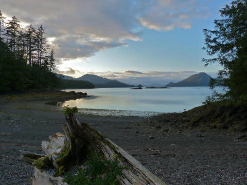
I flew from Toronto to Vancouver and on to Sandspit. Upon arriving I walked to the hotel to dump my gear and went for a stroll. The first road sign that I saw as I walked into town clearly instilled in me, with three simple words, that I was a long way from home. It read “Tsunami Evacuation Route” with an arrow pointing the way. The town itself is all clustered along one main road that travels along the coast. As it turned out I was in time to see the last two hours of the annual Logger Sports Day event. As expected, this is an event that is attended by the entire community with all of the expected logging competitions such as poll climbing, log cutting and of course log rolling.
As a tourist it doesn’t take long for a Bald Eagle to catch your attention and of course you pull out your camera and start taking pictures. They abound in the area and one of my best pictures was taken of one sitting in a tree beside the main road in Sandspit. These birds are fish eaters and scavengers. They tend to nest in locations were marine life is plentiful and build nests in large trees that can support their nests that can weigh up to 900 kg (2000 lbs). They are so abundant that on the trip I took only one more picture of 5 birds sitting in the same tree.
Day one began with the van from Morseby Explorers collecting the 6 guests and the lead guide from their various accommodations. Moresby Explorers is the local company that ferries people and equipment to their destinations around Haida Gwaii. With our personal gear and food supplies loaded we headed off to Moresby Camp. It took only 15 minutes to travel the 22 kilometres of paved road on the Island of Morseby. At that point we embarked on the gruelling trek of another 15 kilometres to the camp. The logging road was apparently made at a time when the gravel crusher was not fully functional and some of the “stones” were only as small as my fist. Needless to say all of us were very thankful when the trip was over and we could exit the van and allow our internal organs to slowly begin settling back into their rightful places. Little did we know that this was to be only a short reprieve before we were subjected to further bodily punishment.
At Morseby Camp our gear was transferred to a Zodiac with makeshift seating. We were instructed to don all of our warmest clothing. After doing so, and before they handed out thick ponchos, we were told that they really mean all of our warm clothing, and we were soon to find out why. The water taxi portion to begin our trip was a heart pounding 4.5 hour trip at 23 knots on the open sea. Needless to say any protection that you had donned was at best barely able to keep you reasonably warm for the long trip on the open ocean trip to Rose Harbour.
On one break on the trip we stopped to observe a pod of Humpback whales that put on a spectacular spectacle of breaching constantly as they passed by. A second stop allowed us to observe a group of Steller Sea Lions resting and sunning on a nearby shoal. We had to keep a minimum distance of 1000 metres, as do all boaters. Apparently Orcas have learned that following boats, including kayaks, which pass closer, can lead to a tasty meal when the group is disrupted and heads to the sea for “relative safety.”
Rose Harbour was the site of one of BC’s most prominent early whaling stations in operation from 1910 to 1943. We met up with a previous group from Kingfisher Adventures across from the old settlement but did not visit as it is now home to a fly-in B&B. From the previous group we inherited our boats, tents and the second guide. After lunch and sorting out our gear among the 6 single and one tandem boats we were given the required Park orientation and headed out for a short paddle to our first camp.
Day two began with us paddling over to Ninstints (formerly Anthony Island) and the former Haida community of SGang Gwaay. The main island is made up of volcanic rock and hosts one of the best examples of a traditional Northwest Coast First Nations village. Visits to the island are limited to parties of 12 persons or less at a time. Permission to land must be obtained from the local Watchman. The Watchman program, established in 1981, is comprised of Haida Gwaii descendants that serve as guardians to protect the natural and cultural heritage of the villages. Upon landing we proceeded along a boardwalk that had been constructed to protect the pathway to the Watchman’s cabin for orientation. Former human habitation is evident in the form of habitation caves, upright and fallen polls, house pits and standing posts and beams of longhouses.
Most carved poles are often mistakenly called totem poles. In fact they are usually mortuary and memorial poles representing family history, lineage, and rights. Carvings typically tell a story and are composed of human, animal and supernatural figures. Mortuary poles are in fact grave sites of a high status person. The poles were carved with crests of the deceased and had a cavity at the top were the remains were placed. Upon death the deceased would lie in state for a period of time and eventually be transferred to a mortuary house. This tradition allowed the eldest son of the deceased’s eldest sister preparation time of up to two years to carve the mortuary pole. Memorial poles were erected in memory of a deceased person whose remains were interred elsewhere or whose body was lost at sea.
You never forget your first sighting of an Orca in the wild. For me this occurred on day three shortly after we had set up camp in a small bay protected by a spit of land. While standing in the kitchen area several of us heard the unmistakable sounds of whales blowing up the coast beyond the spit. All of us took off running towards the sounds and the end of the spit. Upon arriving there we were treated to the spectacle of a pair of Orcas traversing the coastline towards us. As they neared the spit they turned and travelled the length of the spit, only about 100 metres off shore, and proceeded to head out to sea. Of course the opportunity to paddle with whales and truly feel their magnificence up close is the experience of a lifetime.
The temperate coastal rainforest environment is a wonder unto itself. The temperature is constantly cool and pillows of spongy moss and massive trees abound. Some of the cavities within the older trees were almost large enough to pitch your tent in. Since campsites are not marked and known only through local area knowledge, the environment remains pristine. Evidence of how the old growth stands eventually fall, deteriorate and become engulfed in the mossy landscape tell a story that has been repeating itself for thousands of years.
The inter-tidal zone is a fascinating area for exploration and photographic opportunities. Often we would see Sitka black-tailed deer roaming these areas and potential campsites. The species was first introduced to the area in the 1880s as a supplemental source of food. With no natural predators they now populate almost every island in Haida Gwaii. With tides ranging up to 24 feet in the area huge expanses of coastline appear and retreat back to the sea throughout the day. You want to be sure that you have moved your boats high enough up the shoreline to ensure that they are still there the next morning. Discovering the inter-tidal zone on foot affords and incredible opportunity to view much of the diverse marine life up close. Sea anemones, shellfish, kelp and starfish of many colours are only some of the creatures you can examine in small pools of water left behind by the receding tides.
We were blessed with calm seas for several days and afforded the opportunity to paddle along the exposed coast of Burnaby Island. We were able to explore and even paddle into some of the caves carved out by the sea along the shoreline. Often the cave walls held collections of starfish clinging on and awaiting the return of the sea. One of my fondest memories is the opportunity it presented to “rock hop” along the coastline. As the regular sea swells ebb and flow near the shoreline you can challenge your manoeuvring skills to skirt the coastline and view the changing landscape up close. You need to also watch out for the constant presence of large concentrations of Bull Kelp that can bring your kayak to a dead stop. These are long brown tubular hollow structures that end in a round bulbous top. They are attached to the sea floor and the top portions float on the surface. They also make great anchors when you want to remain in one place and take a short break.
Our last campsite was on Kat Island at the northern end of the Burnaby Straight. The next morning we headed off for Burnaby Narrows. You had to be careful getting into your boat to avoid stepping on bat stars. These are gelatinous type starfish that come in a kaleidoscope of colours. They are so plentiful in the area that concentrations of up to 74 per square metre have been counted. The paddle to the narrows was almost magical with the protected waters being as still and calm as glass. In the narrows tidal action pushes seawater through a channel that is just 50 metres wide. This provides a constant stream of plankton, nutrients and oxygen to the organisms that live there. This area contains some of the highest concentrations of marine life found anywhere in the world and the shallow depth of about 1 metre during low tide makes for the ideal situation to view them from a kayak. Marine species include bat stars, sea cucumbers, turban snails, sunflower stars, crabs and sea urchins, to name just a few. The sea bed is so littered with incredible things to view that it overwhelms the senses and you leave knowing that you have only glimpsed some of the wonders to be found.
Shortly after lunch, having returned to Kat Island, saw the arrival of the zodiac and the next group of kayakers, including a good friend and fellow GLSKA member. As my adventure drew to a close so began the experience again for a lucky group of kayakers destined to forge their own unforgettable memories.
Originally published in QAYAQ Volume 24, Number 1, Spring 2012