
by Rob Muylwyk
The excellent “Bruce Peninsula Paddling Destinations” produced by the Georgian Bay Committee, originally published in Qayaq and available on our web-site, ignores one of the Peninsula’s worthwhile interior paddling waters. These are the inland lakes generally referred to as the “Rankin River Route”, consisting of Isaac Lake, Boat Lake, and the river that connects them, named after surveyor Charles Rankin. These are shallow waters, well suitable for flat-water canoeing or kayaking. What they lack in water depth is compensated by the rich nature experience that is guaranteed. I have paddled the Rankin at different times of the year and I have always found it stunningly beautiful. What follows is sort of an aggregate trip report, a combination of many individual outings, be it by kayak or by canoe.
Isaac Lake is located northwest and Boat Lake southwest of Wiarton, between highway 6 and the Lake Huron shore. There are three access points. If you like going with the flow, then the most appropriate one is from a bridge on Red Bay Road, 4 kilometres west of the hamlet of Mar on highway 6. An alternative northern launching point is at the Isaac Lake dock, 2.5 km west of highway 6 at the end of Isaac Lake Road. The drive to this point passes through a nature reserve, well used by breeding geese, swans and wetland birds. As part of the creation of this reserve, a large barn – about halfway down the road – was torn down. As this made a large colony of bats homeless, the MNR erected a large bat-condo for their benefit. The third access point, suitable for taking out when you are shuttling, is on Oliphant Road, 6.5 kilometres from highway 6 at Wiarton’s north hill. This site features an historical plaque as it marks the end of a portage starting at Wiarton. Native travellers would launch here to continue their peninsula shortcut. This point tends to be busy with anglers. There are porta-potties at all three access points.
We’ll launch from Red Bay Road, and as soon as we leave the road and float through the water lilies, that peaceful feeling comes over us. This is the actual river, with forest on the west bank, and marsh on the east. We hear the chattering sound of a pair of kingfishers before we see them flying on to their next favourite kingfishing perch. After 300 metres a channel leads east to Mud Lake, but even with a canoe I’ve always had to turn around – or rather back out – before I could reach it, due to plant growth, floating logs, beaver dams, etc. Continuing south we see an old beaver lodge on the east bank. One spring Iet and I were captivated watching the goings on of a family of river otters who appeared to have taken up residence here. We witnessed a young otter catching a fish and bringing it into the heap of mud and twigs, while a parental otter was swimming circles around it.
From this point we can see a singular dead tree with a large osprey nest on top, and if there’s no bird occupying it, it is usually roaming the sky nearby. On one occasion we found an osprey on the nest, and then we saw another large bird with a rather small one fluttering around it, coming towards the nest. Just above the nest, the large bird gripped the smaller one in its talons and deposited it carefully in the nest: osprey flying lessons!
The river enters Isaac Lake just south of this nest. If we like to do more osprey watching, then we head east, to a pole mounted nest on an area of grazing land abutting the lake. Especially later in the season, navigating Isaac Lake can be frustrating due to the proliferation of bulrushes, hiding small islands over which you may see a hovering northern harrier or a colony of anxiety ridden black terns. All these reeds form wonderful habitat for birds and hungry deer flies, but it makes it difficult to find our way out of the northern section of Isaac, a deeper narrows on the southwest end. After we have passed a few cottages on this channel, we enter the south section, much less wide and more like a river than a lake. We share this area with cormorants, red-winged blackbirds, ducks, geese, and the occasional human fisherman. We hear marsh wrens, but they’re not easy to see. We’re told that there are American bitterns and least bitterns here, but they are even harder to spot. The lake narrows again when we come near the historical portage access point, and we’ll see great blue herons take off slowly and majestically when we enter their space. There’s another osprey nest here, this one perched atop a hydro pole.
We continue by sliding under a low bridge with swallow nests under its beams, then follow the winding river to the next bridge, at Oliphant Road. I paddled this section once with Burke, an ecologist, who gave a running commentary identifying the birds by their song and flowers by their characteristics. He never stopped talking, that’s how productive this wetland is. After the second bridge, we enter the larger Boat Lake. We sometimes do lunch, sitting on a log, on a small island about 1 km down. In summer, deep red cardinal flowers grow here, amidst – alas – the prospering poison ivy. We share this area with another colony of agitated black terns; they’re all bluff and don’t really dive-bomb you, as their common cousins tend to do.
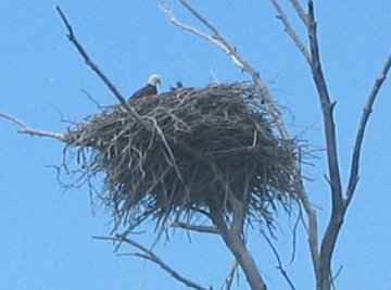
Boat Lake was laid dry in the twenties by blasting the scarp further downstream, but as the land proved useless for farming, it was re-inundated in the sixties by means of a dam. As a result we see numerous stands of dead trees in the water. One such section is at the far west end of the lake, some 2 kilometres southwest of the island, the location of a huge bald eagle nest. Last year we found this nest occupied by a family of two mature and two newborn eagles! The birds don’t feel threatened by us floating in close, and time flies while you are observing these fantastic animals. Just forget that they feed on rotting fish and road kill, and admire their plumage.
Our next task is to find the exit out of Boat Lake into the river again, which is extremely hard to find. Look for a bright orange blaze near the most southern part of the lake, and you’ll find it. We follow the winding river, full of obstacles, but also full of wildlife, to the aforementioned dam. On our way we find snapping and painted turtles, and, if you are lucky enough to have Burke along, an eastern kingbird nest in a hollow on top of a dead pole, with three eggs in it and the parents freaking out above it. Although I may wear a Tilley hat, I am not really a “birder”, so I was duly impressed when Burke logged the nest’s coordinates to report this location to the ROM.
The dam is as far as we go by kayak; canoes can portage around it and continue along the log-strewn river. It takes you through the dunes to the Sauble River, and from there to Sauble Falls, where you can take out, and – at the right time of year – watch the salmon jumping their way up the falls.
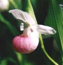
The dam is the nicest lunch spot on the Rankin. In June you’ll find one of my favourite orchids here, the very large and gorgeous showy or queen lady’s slipper. During one of our dam rests, we started to get irritated by the arrival of two ATVs. These carried the landowner and his family, who kept us chatting for a long time about the interesting history of this area.
Now against the current, we head back into Boat Lake for a direct crossing to the Oliphant Road bridge. Often the wind picks up in the afternoon, and we’re glad that we are kayaking rather than catching wind in a canoe. If we end our trip at the second bridge, and followed the route as described, we’ll have paddled about 17 kilometres.
A few years ago I shuttled my daughter and a friend, who got so engrossed in being in a nature setting, that she swore that she had heard a moose calling. When I asked what sound the moose made, she went: “moooooh…” It’s that easy to forget that the forests around the water, especially on the east side, form just a slim barrier between us and the high intensity beef industry of the Bruce Peninsula.