
Nigel Foster
Three small wooden spoons sit on my bookshelf, crudely carved from driftwood found on Lacy Island, one of the Button Islands off the northern tip of Labrador. I carved those spoons after losing my cutlery landing in the dark having crossed Hudson Strait from Resolution Island. I planned to kayak Labrador from its northern tip as far south as Nain, but after two frustrating weeks of delays in Iqaluit it was really too late in the season to begin. It was almost September before I reached the Button Islands, perfect timing for the onset of autumn storms. Eight windy days later, near the deserted village of Port Burwell, I ran into an oil tanker and hitched a ride to Nova Scotia. That was 1981 and I have wanted to return ever since to complete the trip. That finally happened in 2004. This time I began at Kuujjuaq in Ungava Bay, northern Quebec, accompanied by the enigmatic ceramic artist Kristin Nelson, now my wife.
The Koksoak River swollen wide by the morning high tide fell swiftly from Kuujjuaq toward the bay. We almost reached the mouth before the current abruptly reversed direction to stop us. We ferried to the cliff and looked for a place to land for the night. Finding a good place was critical. The tidal range in Ungava Bay is fairly big, up to 12 metres, so we had to work quickly to unload the camping gear and our five-week supply of food and run that up the steep rock to beyond the reach of the tide before we could tackle the empty kayaks. While we worked the water rose fast. By the middle hours of the tide, the water level would be rising 5 centimetres every minute.
Ungava Bay is a wide bay that cuts a bite out of the south shore of Hudson Strait to the west of the Labrador Peninsula. When the tide falls, currents flow in all directions between the ledges as the water escapes into the bay, finally exposing a maze of rocks and ledges, mudflats and boulders that extend that can extend into 5 kilometres of foreshore. After a pause, the water seems to suck back in again, the currents racing in between the ledges to flood the crazy foreshore and inundate the estuaries and bays. It is a fiercely energetic system and a challenge to weave a good line by kayak without getting stranded or swept into backwaters.
We ferry glided across gaps between ledges during both the rising and falling tide. At night we pulled up onto bare rock to camp, marvelling at the glittering crystals in the twisted bands of colour that swirled across the smooth surfaces, and then when the sun had set, watching the aurora borealis twisting green curtains across the sky. But those relatively relaxed days soon ended. Battling forward against the wind, close to the rock, Kristin spotted something nearby that might have been blocks of outcropping quartz. A moment later two polar bears were ambling down toward us. They were quite close to us when they suddenly spooked and ran away. We headed quickly in the opposite direction and from then on kept a little farther from shore just in case.
Our next polar bear experience was more serious. I had landed on a small island for a pee when a polar bear ambled over the summit about 20 metres from me. I called to Kristin, still in her kayak, to reverse onto open water, but she was already grounded by the falling tide. The bear stopped only a metre or so from her and checked her out with some curiosity. I pulled my flare gun from my day hatch, and with my first shot startled the bear away a few metres giving Kristin enough time to get out of her kayak. Then the bear was back, sniffing her rear deck bag while we stood at the bow.
My flares were of no further interest to the bear, but while I continued shooting, Kristin calmly commanded over and over, “Bear, be gone!” After some long minutes of standoff the bear seemed to lose interest and ambled away. As soon as we moved to leave, it hurried back, but we were already afloat and moving away fast. It followed us around the island, and began swimming after us when we reached open water
Bears became a significant part of our trip from then on. We ran into sixteen at uncomfortably close range during the trip, usually spotting these masters of disguise at the last moment.
I was excited to reach the northern tip of the Labrador Peninsula with its distinctive geological landform, faster tide streams and cold foggy conditions. I felt very humble and emotional on reaching Port Burwell, showing Kristin where the oil tanker had been anchored. McLellan Strait, running between the mainland tip of Labrador and Killinek Island, had been one of the reasons I had wanted to get to northernmost Labrador in the first place. The tide is said to run at 10 knots through the narrows during spring tides, but sadly it was now neaps. We decided to camp near the narrows to catch the ebb early next morning, but when a swimming polar bear appeared determined to catch up with us, we modified our plan. Instead we paddled the entire 24-kilometre passage against the tide. We ran into three polar bears that day.
In contrast to Ungava Bay’s big tides, fantastic rock ledges, mud flats with boulders and mostly low shore, Labrador has smaller tides, steep cliffs and coastal mountains; the Torngat Mountains in the north. It also has fog. We spent whole days paddling by compass in straight lines from point to point along the coast, occasionally glimpsing shore, or mountaintops, or the sun gleaming through the blanket like a pale moon. But when the air cleared, we were stunned by magical views of knife-edged ridges and spiky summits, snow slopes and deep fjords. The icebergs too were bigger, more majestic than those we had seen in Ungava Bay. This was the landscape that attracted me in 1978, when, kayaking along the Newfoundland coast with Tim Franklin, we saw the photographs of Labrador that decided my plans for 1981.
Predictably, the paddling was not always easy. Swell suddenly developed one day while crossing calm water in Seven Islands Bay. It looked as if a tide was running into the bay. I watched my course and found I was not drifting sideways. The only other explanation could be wind; wind from the fjord blowing out to sea. We paddled hard for the closest island, but in ten minutes we could see the spray and whitecaps advancing down the fjord toward us. When they hit, we had to struggle to make any progress at all. We had no option but to head into the wind until we reached land, or we would have been blown out to sea. This was the first day of very strong winds during the trip, and as we had expected, they sprang up with little warning, funnelling between the mountains.
At Saglek, we pulled ashore from a rising wind and strolled up to look for the wreckage of a B-26 Marauder bomber that had crash-landed there in 1942 during the Second World War. Now there is an unmanned radar station on the cape above that flat saddle landing site between the mountains.
We were astonished to find some 32 people at a lower site once used by the military. They were clearing up PCBs, washing the rocks and packaging contaminated soil for removal and incineration. We spent the night as their guests, sleeping uneasily in a bed among the now unfamiliar noises of plumbing that woke us in the night imagining polar bears.
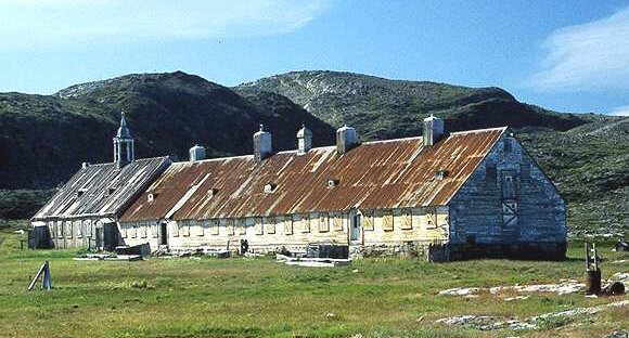
At Hebron, one-time Inuit village and one windy day’s paddle south, stands a magnificent mission house prefabricated and shipped there by the Moravian brethren in the 1800s. This long building, now a heritage site, is under restoration. A team of eight was working on the roof, trying to get it re-shingled before the winter storms. It was from these Inuit working at Hebron, and at Saglek, that we gained local knowledge about the next section of coast. All the villages along this northern coast were evacuated in the 1950s at the direction of the government who thought the people should live farther south in towns where jobs and housing would eventually be available, rather than subsistence hunting along the coast.
At their suggestion, we followed a route between the precipitous cliffs of Cod Bag Harbour to a narrow isthmus between the mountains. We camped at this portage point surrounded by ancient tent circles and stone burial cairns overlooked by tall mountains, with caribou wandering past and seals basking on the rocks in the bay.
Our route south ran between the Okak Islands across the northern tree line. We imagined we might now see fewer polar bears and more black bears, but we saw each in equal measure. The occasional hut we passed on the shore told us we were approaching civilization again. We rounded the Kiglapiat Mountains on a sunny day and entered Port Manvers Run, a channel running in the protection of South Aulatsivik Island. Here we met Jim and Helena Andersen at their cozy cabin and shared their arctic char, contributing boleti that we collected.
With just a short hop left to Nain, the weather turned windy. It was early September, and just as in 1981 in northern Labrador, the winds sprang up and blew hard. When the wind finally eased and the sky cleared, snow coated the mountains and frost encased our kayaks. Now on glassy water we paddled the few remaining miles to Nain.
We had spent just over five weeks exploring a very special wild and beautiful coast. We saw few people but many signs of earlier inhabitants; tent circles and chert shards, Inuksuit, caches and graves. This coast for the moment is uninhabited wilderness but it was inhabited for thousands of years before the people were relocated. A National Park has just been designated for the area that will generate more tourism, and there’s talk of mineral development north of Nain as well. Places change. I’m glad we saw it when we did.
Nigel and Kristin live in Seattle, Washington, USA. Kristin makes ceramics for a living while Nigel makes his living from kayaking: writing books, teaching, giving presentations and designing kayaks, paddles and accessories. Nigel has written a book about Labrador, including this trip, and is currently seeking a publisher. For more information visit Nigel Foster’s web-site: www.nigelfosterdesigns.com.
Reprinted from Ebb & Flow, Spring 2006, the newsletter of Kayak Newfoundland and Labrador. Photo courtesy of Pinetreeline.