
by Melissa Hachkowski
I remembered learning about Lake Nipigon in elementary school when we read Holling C. Holling’s book Paddle to the Sea. “Paddle” was released into Lake Nipigon, travelled the river to Lake Superior and then out the Great Lakes to the St. Lawrence River. Since I am addicted to Lake Superior, I thought Nipigon had to be just as good. A fifteen-hour drive from Barrie got me to the northern Ontario town of Beardmore, one of two potential access points along the entire 350-kilometre coastline. The alternate is the town of Gull Bay on the western shore. Parking at the Poplar Point Lodge trailer park, at the end of Highway 580, I quickly loaded my kayak and headed out in the early afternoon for a light 24-kilometre start. Within the first five kilometres, I saw my first bear and was excited by sight of wildlife. From then on, I lost track of how many times I saw bears wandering the coast. I soon stopped looking at the shoreline because I found it disturbing to see THAT many bears.
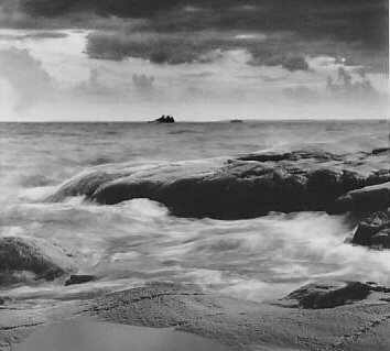
The size of Lake Nipigon is the first thing that grabs your attention as you float by the shoreline. There are islands off in the distance somewhere where the water’s horizon line meets the sky. There is no hint of land on the other side. Islands, that according to topographic maps were about fourteen kilometres away, strangely looked to be closer to 20-25 kilometres away. I decided to travel in a counter clockwise direction around the lake, concentrating on the coastline of what had once been considered as the sixth Great Lake.
The trip had been originally planned as a ten-day trip, doing a leisurely 30-40 kilometres per day. It ended up being an exhausting five and a half days instead, for a number of reasons. If you are going to go, June and July are supposed to be the best months. I went in August, not by choice but because of obligations with work. I paid the price. When launching from Poplar Point Lodge, a young summer employee informed me “the weather’s been bad these past couple of days, wind blows up from nowhere and it seems to rain daily…” She wasn’t kidding. The day I launched was the last day of sun I saw.
The typical forecast at 4 a.m. was: “…becoming cloudy by early morning with winds of 35 km/h gusting to 50 km/h. Rain will start by late morning with a severe thunder storm warning, clearing late this evening with winds continuing.” The strength of the wind was similar to what I’ve experienced on Lake Superior. The waves would have been the same large rolling type found on Superior as well, except there are so many rocky outcroppings, reefs and islands that interference of wave patterns is the norm, resulting it total chaos on the water – resembling at times a giant, man-eating washing machine effect. Unfortunately, I am very light in my kayak, and the boat had lots of extra empty space. This wasn’t a full out expedition after all. As a result, the waves tossed my boat randomly in every direction. I know how to brace but have never before had to brace to stay upright, until this trip.
One day, with a tail wind of 30 km/h, I passed by a small smooth rock being washed over by waves and did a double take. There was a large white bird attempting to get shelter on it. It was a White Pelican that at first looked like a plastic toy. I was lucky to get to see this, as they are an endangered species and this is the eastern most area of their habitation; although sitting on that exposed rock in this storm, I didn’t think it would be around much longer.
Realizing that the weather conditions were now reaching the ridiculous stage, I knew I had to get to a safe landing or shelter fast. This is difficult, to say the least, considering that much of Nipigon is boulder and rocky shorelines. The “beach” at the shoreline is often not wider than six feet and then you have the tree line. Try to pitch a tent in that six feet, on rocks with crashing surf – it just doesn’t happen. The entrance to Ombabika Bay was just under one hour back and I thought it was my best bet, and what I thought was my only chance for a little shelter from the storm.
The one-kilometre wide entrance to Ombabika Bay has Ombabika Island in the centre, which takes up about 80% of its width resulting in two very narrow channels on either side of the island. I had totally underestimated the combined power of the waves and wind entering Ombabika Bay. I was thrown through the channel, faster than the waves were travelling. The resulting effect was that the bow of my kayak tunneled straight through the waves with me still in the seat. I would say “Hold on for dear life,” but there is absolutely no way you could have gotten my favourite paddle out of my hands with the death grip I had on it. A ride that I’m sure lasted no more than five minutes felt like an hour and then my kayak seemed to curl randomly around in a 180 degree turn to the right and stand still, floating beneath the foam from the previous waves.
In front of me on the right was the still raging storm I had come through. On the left, was the most gorgeous lagoon created by a small peninsula jutting out from Ombabika Island, sheltered from every direction except the north. The water sparkled and I didn’t need to think twice where I would head. As I landed on solid ground, I thought I was in for a treat at this small white sand beach, surrounded by the high cliffs of the island.
I noticed that there seemed to be three small clearings along this beach, just behind the tree line, deep in behind the lagoon. Had I found another established campsite? I was ecstatic, until I started to explore a little. What I found looked like the remains of a Stephen King horror story in the Canadian North Country.
The first of these clearings looked as though someone had set up a tent, probably last summer or the one before. They had left it there set up, but why? Clearly the tent had collapsed onto the ground and parts of the fabric were torn. But it didn’t make any sense as to why someone would leave a tent. I wandered around this site some more, not wanting to touch anything. There was a thunderbox, that had been knocked over and then there was a trail that led to the second cleared site.
At this site, I found what looked like a garbage dump. There were stacks of boxes of beer bottles that had been toppled over. There were green garbage bags that had been ripped open spilling out metal cans, plastic bottles and styrofoam plates from produce at the grocery store. There was even an electric oven, small cube freezer without the lid and a refrigerator. Again I wandered and took a second look at the contents of this site, kicking some stuff as I went. Something odd … not quite right. Oh My God! Every piece of garbage had the teeth marks of a bear through them, including the metal. The lid of the freezer had the claw marks where it had been pried off of the hinges. There were claw marks on a few of the trees around. I continued on the trail to the last site, now regularly looking over my shoulder for any movement in the bush.
Along the trail I found one of the dumbest things I have ever seen. Someone had started a fire in the middle of a now dead stand of spruce trees. The non-intelligence of this act was alarming, since a forest fire ripped through the area, probably about seven years ago. Evidence of this had disturbed me back on the first day of paddling, where for about the first 25 kilometres there was not much more than dead trees, blueberry bushes, small shrubs and bears along the coastline.
The third clearing had a couple of broken old chairs, piles of discarded bleach bottles, old fishing nets and the marker buoys used for them. A few fish crates had been thrown in the bush as well. There were also more bags of garbage and beer bottles here, as well as recent evidence of a bear visit. There was absolutely no way I could stay here, but I remembered a small smooth rock about a hundred metres back along the entrance to the lagoon that was going to be my only other option.
After pitching my tent, I decided to explore a little. I should have known better. Not far behind my tent was a rough trail that I followed and it went all the way back to the three former sites! At first, this didn’t concern me, as it appeared to be very over grown and it was fairly exposed to the elements. Wildlife doesn’t usually like to come out in such exposed conditions, I reasoned. Upon my return to the tent, though, concern grew again. I was watching the trees and ground around in more detail. No scratch marks were present. However, bear scat was and I figured it was probably about a week old from its dryness. There were also bones, the size of a human femur I imagined. Large bones – definitely some from this year and some from longer ago. I forced myself to think they were moose, deer or caribou, but that collapsed tent was still not more than a hundred metres away… Sleep was minimal that night – and for the rest of the trip. There were numerous sites, mostly at the best landing possibilities, that had garbage thrown about, fire pits scattered around and crumbling remains of old hunting and fishing shacks.
The rough weather and wildlife sightings continued, and my paddling days got longer and longer until a final day of 86 kilometres got me back to the safety of my car. There wasn’t one place that I landed that didn’t have bear tracks through it, so personal safety was always at the front of my mind.
If you plan on visiting Lake Nipigon’s coast, be prepared to paddle a lot. Funny how easy it is to laugh about it all now.