
by Donna Griffin-Smith
Saturday June 28, 2003; finally we are ready. Plans for our trip began more than a year ago, and moved into high gear in May as we packed all the equipment we thought we would need for an extended cross Canada road trip, plus all our gear and dried foods for kayaking on the west coast.
When we finally reached BC we made our way to Port Hardy at the north end of Vancouver Island and installed ourselves in a local campground for several days while we planned our menu, sorted and resorted gear and food, discarded things that we didn’t really need and then went to town and bought more stuff that we really needed. Then back to the campsite to sort and resort and discard again. On the fourth day we did a trial pack to see if it would all fit in the boats. More discussion and tossing – did we really need two ballpoint pens? After five days everything was stuffed into five large feed bags that we could barely lift. We were ready!
This was no ordinary kayak trip, in that the only way to reach the launching point was an overnight voyage by ferry. Our destination was the Hakai Recreation Area. Located on the Central Coast of British Columbia, south of Bella Bella, Hakai is an archipelago of small islands, 123 000 hectares in area, and is BC’s largest marine park, as well as the ancestral home of the Heiltsuk First Nation. Today the area is a popular destination for sport fishermen and a paradise for kayakers. Its main community is Bella Bella, which has no road access and is serviced by air or the Discovery Coast Ferry. Our kayaks were loaded onto the ferry on a kayak cart and our gear went on the baggage cart. We were walk-on passengers.
We boarded the ferry about 8:30 p.m. and immediately went up to the lounge to stake out our territory for the voyage – that meant choosing a place to sleep. We had a choice of reclining chairs in the lounge, a place on the floor, or we could have even pitched our tent on the deck. After exploring the ship we decided to put our thermarest mattresses on the floor inside a solarium on the upper deck. As we watched the sun set in the west it seemed like a perfect choice. I had visions of lying there, watching the moon and stars through the glass roof as the ship sailed away through the night. Not so!
The ferry finally departed at 10:30 p.m., one hour late, and about ten minutes later sailed into a huge bank of thick black clouds and we could see nothing. As the ferry left the protection of Vancouver Island and crossed Queen’s Sound the ocean became very rough, the wind howled and the ship rolled from side to side for about three or four hours. First my head was up, then it was down, and on top of that I was freezing. We had taken our mattresses up on deck, but no sleeping bags – big mistake! Even wearing my heaviest fleece and complete rain suit, I was cold and sleepless, but afraid to venture out onto the deck and down the stairs to the lounge in the dark. (Remember the White Squall?)
Eventually the ship reached the calm waters of the sheltered Inside Passage and I dozed off, but awoke around 6 a.m., in time to go out on deck to watch two kayakers wet launch from the back of the ferry. This is a unique service that BC Ferries offers on the Discovery Coast route. Weather permitting you can arrange with the captain for the ferry to stop at a place of your choosing along the route and they will launch you, in your kayak, from the back ramp of the ferry which is lowered to water level. Likewise you can arrange a pick up by contacting the ferry by VHF radio.
As the two kayakers paddled away into the cold grey dawn they looked so small and lonely, I was glad we had decided to disembark at McLoughlin Bay, which is the ferry terminal just south of Bella Bella. As the ship sailed on to our destination we enjoyed a hearty breakfast and got our first impressions of this landscape that would be our world for the next two weeks. Large, forested islands, their mountainous tops draped in low cloud, with rocky shorelines and no place to land, not even for a little kayak. We had heard that fresh water, beaches and campsites were few and far between in this island wilderness. Now it was reality. Suddenly the captain announced that there were whales off the starboard bow. Everyone rushed out on the deck to watch as a pod of orcas surrounded the ship and swam along with us for about ten minutes.
We arrived at McLoughlin Bay at 7:30 a.m. It took over an hour for the baggage and kayak carts to be unloaded. Fortunately there was a small gravel beach next to the ferry terminal where we could launch, so it was not far to carry the gear. By ten we had stuffed all our gear into the hatches, in the cockpit and on deck. We were relieved – everything fit and nothing had to be left behind. But we still had to get fresh water. We were told that the water at the terminal was not safe for drinking, but we could get water at Bella Bella, about 2 km to the north. There we learned that the water hose to the wharf was not working, so Don had to walk up to a nearby store to fill our water bags. By 11:30 we were finally on our way. We headed towards the Seaforth Channel to the north of Campbell Island.
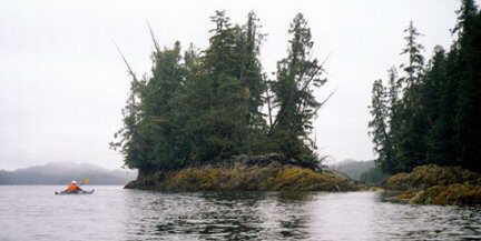
Meanwhile the sunny morning had changed to a cool and cloudy afternoon, and soon it started to rain. Just a little shower, but we started to look for a campsite. We checked the maps, both marine charts and topos, for possible beaches and stopped to check out several locations. However these islands are not user friendly. The dense tangled forest comes right to the water’s edge, and what appears to be a beach at low tide, usually disappears at high tide.
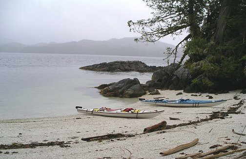
At Kynumpt Bay, after one fruitless exploration on shore, I was getting back into my kayak, when I lost my balance and sat in the water by mistake. Oops! Then to add insult to injury it started to pour rain and I was totally soaked. Fortunately Don had found a good spot to camp – a small, crushed stone beach that would not flood at high tide with a tiny, mossy tent site that had been hacked out of the forest by previous campers. We quickly put up our tent and kitchen shelter, just in time, as a steady downpour began that lasted all night. We spent the evening in our cozy rain shelter, watching aircraft land and take off from the Bella Bella airport. So close, yet so far from civilization.
By morning the rain had stopped but it was a gloomy, overcast day. We were up at 6:00 a.m. but took our time with breakfast and packing. The tide was very low but by the time we had the kayaks loaded the water had risen to meet the boats so we didn’t have to lift them at all. And it only took five hours to achieve this moment of perfection!
We set out with no specific route in mind. First we paddled westward along the busy Seaforth Channel where we saw many fishing boats and a giant cruise ship. To the north rainstorms lurked among the mountains, but none reached out for us. From here we had a choice of several narrow passages leading southward. The charts indicated that there were strong tidal currents and one was marked “tidal falls,” so we knew we would have to paddle through at slack tide (when the tide reaches its highest or lowest point). Our tide chart told us the high slack was at about 3 p.m. which meant that, after that time, we should have an ebbing tide to carry us through if we chose Rait Narrows and Joassa Channel. So we stopped at a small beach for lunch and to wait for the tide. In the narrows, the passage was only a few metres wide; the steep rocky shoreline and huge trees hovered overhead. As we entered Joassa Channel the wind picked up, the sky cleared and we enjoyed a brief burst of sunshine. As if to pay for the change in weather, we paddled into a head wind all afternoon and didn’t even notice the benefit of the ebbing tide.
In the late afternoon we found a place to camp at Reba Point at the north end of Potts Island. At the end of a long inlet a small stream and the tide had worked to create a high gravel bar, perfectly level, just large enough for the tent and, hopefully, high enough above the highest tide in the middle of the night. Farther along the shoreline we found a flat spot for our kitchen tarp – later the high tide came right up to the guy ropes. The kayaks were pulled up into the trees. However at low tide the inlet completely drained like a bath tub, leaving an assortment of inter tidal creatures to examine, including a stranded ling cod. The ugliest fish I have ever seen!
We got to know this inlet intimately, because during the evening it rained several times, with sunny breaks in between, but by night a steady downpour began which continued all the next day. It was July 1, our fourteenth wedding anniversary. We celebrated by huddling under the rain tarp all day. For fun, we collected rain water in a bucket, filled our water containers and took a bath with the extra water.
In my journal I wrote: “We slept in ’til almost 10:00, then got up for a leisurely breakfast of ham, French toast, syrup and coffee under our wonderful kitchen tarp. It is quite roomy for two and with the sides on it we are dry and cozy. ”
Later in the day I wrote: “Still raining – occasional gusts of wind lift the tarp and drain off the puddles. Our bucket catches the rain and it’s overflowing. The tarp drips along the seams. It is very quiet – not a sign of humans – no boats.” We were so alone!
By the next morning the rain had slowed to a heavy mist, and we couldn’t decide whether to go or stay. Finally we packed up and started to paddle about noon. Our goal was the Tribal Group of islands about 10 km to the south. From our research on the area we understood that there was a campsite there – somewhere. We searched the shorelines of every island – no possible place to pitch a tent. To the west a mean looking rainstorm was blowing in our direction. We backtracked to an island we had passed during the afternoon. It was a difficult, rocky place to land the boats, but we could see a strip of dry gravel beach at the base of a steep rock face. We pitched the tent on a flat spot that previous campers had leveled off, and hoped the tide would not flood our bed in the middle of the night.
The next morning was cloudy, cool and windy, but not raining! Before packing we took the time to dry our tent and other soggy gear. As we started to paddle about 11:30, we met strong inflowing tidal currents as we crossed the channel and between islands. We headed southeast and island hopped across a large bay, stopping for lunch at a beautiful sandy cove surrounded on all sides by three islets. It would have made a perfect campsite, but for the fact that it would be completely under water at high tide.
Our destination that afternoon was a campsite at the south end of Campbell Island which the guide book described as follows: “Graced with spring wildflowers, the small island off Soulsby Point has a white shell beach and room for two or three tents.” Sounded like a five star resort, and it was – perfect. The private tent spots were hidden in the forest, and the small crescent beach was of pure white crushed shells – a good thing it turned out, for this was the scene of the great spaghetti disaster. While draining the noodles, the pot slipped and our supper spilled all over the beach. Thanks to the clean shell beach, we were able to retrieve, reheat and eat. Extra calcium – priceless!
It was such a great campsite we didn’t mind that it started raining shortly after the tent and tarp were set up. When it was still raining the next morning, we decided not to paddle. Between showers we explored the beach at low tide – lots of clams, starfish and other interesting critters – and kept a count of the local bird life. A blue heron caught worm-like creatures on the beach; rufous backed humming birds repeatedly checked out red flowers and the red bandana on our clothes line; western crows selected delicacies from the beach to hide among the rocks above the tide line; a pair of noisy woodpecker youngsters chirped incessantly for their mother to feed them; a chorus of winter wrens sang from the forest, and two red throated loons floated by.
And when it rained we sat under our leaking tarp and planned the ultimate rain tarp/kitchen shelter that we would construct as soon as we got home. Once in mid-afternoon I saw blue sky and the sun shone for a few moments. I actually ran out to take a photo of the shadows on the beach. We needed a change in the weather – soon!
Finally on the seventh day of the trip the sun shone. We were up early and paddling by 9:30. As we paddled away I looked back and saw the crows on the beach, picking up spaghetti. We caught the last 2 hours of the ebbing tide as we paddled south along the east side of the McNaughton Group towards Cultus Sound. Even with a stop to collect fresh water at a stream, and a side trip to see two waterfalls flowing in from a tidal lagoon, we reached our next campsite by noon. This one was a classic – a beautiful sand beach about a kilometre long, with a choice of three or four tent sites in the forest. We took advantage of the warm sunny afternoon to dry all our gear and soak up some rays. It was amazing how good the place looked in the sunshine!
Later in the evening we had visitors. A flat bottom fishing boat chugged into the bay and two native fishermen stopped to say hello. After a brief conversation they asked if we wanted a fish. “Just a small one,” Don said, and the guy in the bow threw a beautiful salmon onto the beach. When Don expressed his concern about fresh fish and wild animals (bears) they told us to hang it in a tree. The next morning the fish was safe and sound, so Don cleaned it and we packed the fillets in the bottom of the hatch to keep them cool until supper. But we didn’t need to worry about that.
While Ontario baked in a heat wave, we were thankful for temperatures of only 14 degrees, but it was sunny – all day. We continued southwards down Spider Channel, stopping for water at Spider Island at the location of a WWII Military Base where we found remnants of a wooden road that led across the island. However it was too overgrown to follow without great effort. At Triquet Island we found another gorgeous campsite with a sheltered white sand beach, several tent sites and a box toilet. We shared our campsite and our salmon dinner with two paddlers, Guy and Sheri, whom we had met on the ferry. As well we met one other paddler who was camped with a friend on a nearby beach. These were the only other kayakers we met on the entire trip. Hakai is not a crowded destination.
The next day we opted to stay at Triquet Island for another day, and went out for a short paddle to explore some of the neighbouring islands. However, away from the sheltered environs of our campsite, it was very cold and windy so we returned for a lunch of hot soup and chocolate. Later in the afternoon it started raining again. We had set up our tarp under a huge cedar that leaned over the beach, and protected us from the rain. Our kitchen had several large round logs that made a table and chairs, and we were warm and dry. Let it rain!
And it did. We awoke to a marginal day with strong southwest winds. But we were anxious to move on as the forecast for the next few days did not sound promising. We retraced our route of the last two days, stopping for lunch at the beach at Cultus Sound. Most of the way we enjoyed the shelter of islands so we were spared from the large swells except for a 3 km stretch at Superstition Point. Luckily the tide was high enough that we could sneak through a small passage clogged with kelp and avoid paddling around the exposed headland. The kelp acts like a breakwater, stopping the waves and calming the water.
Back at the same campsite at Soulsby Point, we again shared the campsite with Guy and Sheri. And again, not long after we were set up, it began to rain. As the mountains on the opposite shore drifted in and out of sight behind misty clouds, we reached a decision. We had had enough rain. For us, 9/11 meant nine days of rain in eleven. The next day was Wednesday and a ferry would sail from Bella Bella to Port Hardy at 7:45 p.m. and we would be on it.
My journal for the last day reads: “Up early and packed dry – paddling by 9:30. Weather looks good – high clouds, bright and warm, light winds.” It was a perfect paddling day but once we had decided to go, there was no turning back. We reached McLoughlin Bay and were ready for the ferry by 3 p.m. And while we waited, guess what – it rained.
Our overnight return voyage was peaceful. We enjoyed a delicious roast beef supper and hot showers on board before the ferry sailed. This time we slept in comfort on one of the reclining lounge chairs (with a sleeping bag) and rose early to watch a sparkling sunrise over the ocean. Would we return to the Hakai? Yes. It has everything: remote wilderness, spectacular scenery and wildlife, a variety of challenging paddling routes, of which we sampled only a few, and it’s not crowded. As for the rain, well I guess there’s a reason why it’s known as “the rain coast.” But a weather guarantee would be nice!
It has everything: remote wilderness, spectacular scenery …