
Howard Williams & Rudi Rauch
The southeast corner of Georgian Bay is a place of water, rocks of the Canadian Shield and bush, which in many instances, clings to minute rock crevices, obtaining nurture from small amounts of soil. Yet part of Beausoleil Island, the largest island in Georgian Bay Islands National Park (GBINP), has a different geological nature and indeed different vegetation. (The park offers programmes that include hikes through the different parts of this island.)
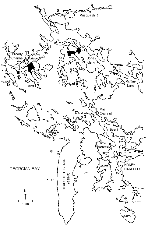
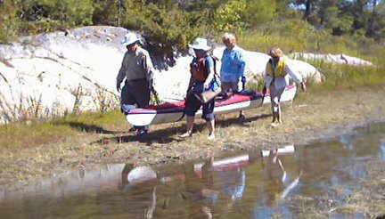
An interesting overnight trip of about 40 kilometres takes the paddler from Honey Harbour to Beausoleil Island, through Freddy Channel to the McRea Lake rapids on the McDonald River, then back to Honey Harbour. The waters paddled vary from the protected waters of the Main Channel, Freddy Channel and the Musquash Channel to the open waters northwest of Beausoleil Island. Paddling the shoreline and channels allow you to see variety in residences and natural waterscapes. The protected areas of the GBIN Parks allow you to enjoy places to stretch and relax. Campsites at Honeymoon Bay on Beausoleil Island may be booked with the GBINP in Honey Harbour. Limited camping space may be available at McRea Lake rapids. More campsites are likely available in McRea Lake Provincial Reserve. To reach these sites kayaks must be lifted over the rapids
Honey Harbour is a tourist-oriented community with many marinas that service cottages and businesses throughout the area plus a large resort, the Delewana Inn. Beyond the park lands and Honey Harbour the area is one of cottages.
Cottages have been a part of the landscape for 150 years. As the foresters logged the area and fishers fished the waters, families came to the area from the southern part of Canada and the northern areas of the United States. They came initially by rail to Waubaushene and Midland and transferred bag and baggage to steam boats for the final voyage to the “cottage.” There were few roads servicing the area. People brought with them everything needed to live during their expected stay. Local residents were contracted to cut and store ice for the summer period. Today, many property owners are able to drive to their locations. Those who can not do so have their own boats at marinas located along the shore. Most, if not all, cottages are now serviced with electricity.
Despite the population, the area is one of beauty and worth the time spent exploring it.
A look at either a map or chart gives information about the background of the area. Champlain was the first of many French nationals who came and left place names. The traders and loggers followed and it was not long before the British military made its influence felt with a naval base at Penetanguishene.
The best time to make this trip is May through September. However, boat traffic in May, June and September is greatly reduced and there are better opportunities for finding camping space at Honeymoon Bay. There are cottages and year round residences along all of the shoreline and islands except the GBINP property on Beausoleil Island, Bone Island and Portage Island. There is extensive motor and sailboat activity in the area on weekends. Some areas are open and exposed to strong northwest winds. Rest and stretch stops must be planned due to the extent of private property ownership of the waterfront land. Poison Ivy can be found on Beausoleil Island
The best starting point is the dock and launch ramp next to the Georgian Bay Township Library in the village of Honey Harbour. The library is next to the GBINP offices. No launch fee is required. Parking is available for minimal cost per day at a private residence opposite the GBINP offices. Parking space may be limited during July and August. Most of the marinas in the immediate area also offer parking and launching for a fee.
POINTS OF INTEREST
(See Map)
- Delewana Inn: This is the only surviving large summer hotel in the area. It operates three seasons of the year providing accommodation for individuals and conferences. The space immediately across the narrow channel was once occupied by the Royal Hotel and one can still see artifacts on the shore with careful inspection.
- Frying Pan Bay: This popular bay on the north shore of Beausoleil Island is used as an anchorage for all manner of sail and power boats.
- Honeymoon Bay: This bay, on the northeast tip of Beausoleil Island, may provide a convenient rest/stretch stop. Find the gazebo perched on the rocky bluff; it affords a view of the water north of the Island.
- McRea Lake Provincial Preserve Park: The park may be heavily used during July and August. If campsites below the rapids are not available it is possible to life over 10 metres to launch in McRea Lake. There are many campsites along the shores of the lake.

- Southeast Georgian Bay
- Wooden Cross: It is said that a canoe tripper lost a child in the rapids at McRea Lake and erected this cross on the rocks below the rapids in memory.
- Bone Island: This island is part of GBINP and may be accessed on either side for rest/stretch stops. (The GBINP property on Portage Island is not readily accessible due to rocks and bush.)
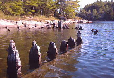
- Muskoka Mills: A company village, with a school and twenty houses, existed here between 1869 and 1895. There were many docks plus one structure which extended 720 m into the Bay. There is still refuse along the shore. The current low water levels allow you to see the extent of mill refuse along both shores of the lower Musquash River. Environmental concerns led to charges against the Muskoka Milling and Lumber Company. The success of the legal action is attested to by the condition of the area.
- Lumber Barge: On the north shore of the Musquash River is the remains of what could have been a lumber barge. Once again the ribs of the vessel are visible due to lower water levels in recent years.
- Community Open Church: This open church, on the south shore of Freddy Channel, features a covered altar, washrooms and many docks. If you stop at the appropriate time you could take part in a service being held there. One of the residents donated the land and the Cognashene Cottagers Association assisted in the construction.
- Marina: This marina, on the north shore of Burnt Island, includes a restaurant and motel (botel?). In the summer months it stocks ice cream and serves as a possible rest/stretch stop. Landing at the docks may be a challenge for kayaks, but it can be done.
- Houseboat: Look for an unusual 2-story structure on the north shore of Freddy Channel. It is one of two remaining houseboats in the area, which have been beached and transferred to timbers and pilings on the shore. The other is located on Keating Island.
- Maxwell Island: This island is also known as Whalen Island. The latter name derives from a Mrs. Whalen from Penetanguishene who came in the summer to escape allergy problems on the mainland and provided tourist accommodation. By 1912, the tourist area on the island was known as Cognashene. A post office, farm animals and a store to supply food for the island and area residents soon followed. The Whalen Island Summer House was destroyed by fire in 1942. All that remains of Grandma Whalen’s business ventures are her descendants’ summer residences. The island was also used for open-air church services by cottagers in the area.
- YMCA Camp: As you move from Muskoka Landing Channel towards Beausoleil Island you will see the long, low buildings of the London YMCA Camp. The red coloured shingles on the buildings provide a good piloting feature for the return trip to Beausoleil Island.
ADDITIONAL INFORMATION
Maps
Maps: 1:50,000 Penetanguishene (31 D/13). (Note: Georgian Bay water levels in 2003 made passage by kayak between Burnt Island and Portage Island impossible unless you are prepared for a 100-metre lift-over.)
CanMatrix – Print Ready – 031D13 – Penetanguishene, Ontario
Charts
Chart 2241 – Port Severn to/à Christian Island
Camping
Camping: For further information and campsite reservations visit the Parks Canada – Georgian Bay Islands National Park – Georgian Bay Islands National Park of Canada website.
This is one in a series of trip descriptions collected by the Georgian Bay Committee for a paddling guide to the Bay.