
Donna Griffin-Smith
Monday, August 2, 6 a.m.: Our group of eight kayakers stood on the beach staring into a dense pea soup fog. Contrary to its reputation, Lake Superior was flat calm. Not a whisper of wind and no waves. Somewhere before us, were the Slate Islands. We knew they were out there somewhere, but where?
The Slate Islands are located about 13 kilometres off shore from Terrace Bay on the north shore of Lake Superior and are a popular destination for local residents as well as canoeists, kayakers and pleasure boaters. This group of islands (17 in all) is an undeveloped Provincial Park (no fees). The two largest islands – Mortimer to the north and Patterson to the south – form a protected “lake within a lake” with many smaller islands in the centre. This inner body of water is always sheltered, regardless of the conditions out on the big lake. The islands are believed to be the site of an ancient meteorite impact crater and the resulting rebound effect produced the circular island group. As a result it is geologically significant for those who know what to look for. (I must admit never did see shatter cones as I had no idea what to look for). They are also home to a herd of woodland caribou which were much easier to recognize and were in fact quite abundant. The scenery was superb. The high rocky islands are covered with dense spruce forest and every shoreline we paddled was picture perfect with sheer rock faces, sandy beaches and sparkling blue water. The topo map shows the highest point of land on Mortimer Island at 950 metres, and Patterson Island has numerous small lakes and high contours as well.
Our group of GLSKA members, Don and I, Elke, Bill, Joe, David, Rick and Cindy, had rendezvoused at the campground in Terrace Bay the previous day so that we could get an early start in the morning. Weather on Lake Superior is always a serious consideration. On Sunday we had an afternoon rainstorm followed by a beautiful sunny evening and the weather radio promised good conditions for the next few days. Although a shuttle service to the Slates was locally available, our group of experienced paddlers was eager to paddle out to the islands. We had expected some wind and waves, but not fog and dead calm!
The previous evening we had stood on the same beach, and we had seen the islands in the distance. They really did exist. We had taken a line-of-sight bearing with the compass (Just in case of fog, Don predicted.) and those with a GPS had marked the way points, so we felt confident about the 13 kilometre, two-and-a-half-hour crossing required to reach our destination.
It seemed the greatest danger this day would be getting separated from the guys with the GPS, so we all stayed close together. It was an eerie feeling to paddle in the fog with no sense of speed or direction. After a few minutes the land behind us disappeared and silence wrapped around us like a blanket. After about an hour and a half we were finally able to make out the first signs of a distant shoreline and eventually the high tree line of the Slates emerged out of the mist.
Right on the two-and-a-half-hour mark we landed on a rocky point at the eastern end of Mortimer Island and took a much needed break for leg stretching, which we accomplished by running across the beach and into the bushes, guys to the right, girls to the left. Then we continued on, following the shoreline of Mortimer Island, past an awesome lichen covered rock face and into McGreevy Harbour where we began to look for a campsite. Our plan was to set up a base camp from which we could travel each day to different parts of the islands without packing up. This was to be a leisurely trip!
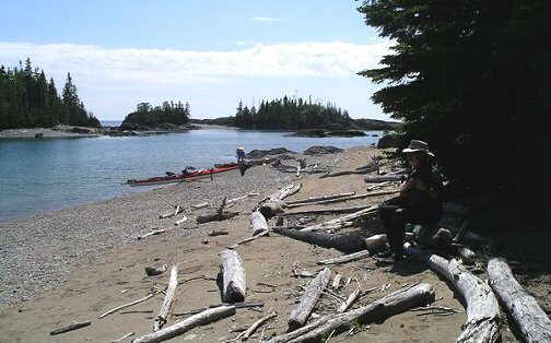
In McGreevy Harbour we checked out a couple of well used campsites at the north end of Patterson Island, and decided on one that had lots of room for six tents, was centrally located and provided shelter in case of bad weather. Plus it had a great sand beach to pamper the bottoms of our boats.
Its other features could be rated as pluses or minuses depending on your point of view. There was a large fire pit with benches for sitting around, some built-in tables and counters, and a structure of poles ready for putting up a windbreak (which we appreciated later in the week). Now some would reject a campsite with these “comforts” as being too civilized, but the redeeming feature was a huge picnic table, large enough for eight to sit comfortably and so high off the ground that I felt like a child as I sat and swung my feet back and forth. That table certainly did not arrive by kayak! Our thunder box, however, left a lot to be desired. What it lacked in privacy (a few boards nailed to two trees to block the view) was made up for in airiness (no bad smells here). After use, you had to kick in a boot-full of sand to cover up, as the “box” lacked all four sides and the “seat” was a few strategically placed boards between two trees. But the view of the bay was excellent!
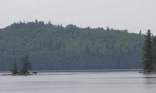
After our camp was set up we explored our neighbourhood. Several group members hiked along the shoreline, and I followed a well-travelled path through the forest, which led to another beach on the eastern side of our peninsula. I was surprised at the large number of well-beaten paths I found, and soon realized these were caribou trails. Not long after the tents were set up Joe called us to come and look at something out in the water. It was an animal swimming across the bay in front of our camp. As it reached a small island, it waded ashore and disappeared into the trees. A few moments later it reentered the water and continued on to the next island. Its huge antlers identified it as a large adult male caribou. We were so excited – our first caribou sighting! By evening several other caribou had been spotted near the campsite and swimming in the harbour.
Did you know that caribou do not sleep at night? No, they wander through campsites and bump into tents. Just ask Bill about his caribou friend. After the first night we realized that anything that went thump in the dark was probably just another caribou and every morning there were fresh tracks on the beach. At night we turned our boats sideways on the beach so the caribou would not trip over them or step in the cockpits. One evening Elke and I were sitting by the water’s edge watching the sunset when a caribou came along the beach behind us. We were so busy talking we didn’t hear it, but the others told us it turned and went the other way. We soon learned that the caribou on the Slates were not the least bit afraid of people. There was a young one (Cindy called him a dumb teenager) that frequently visited our camp site and liked to lick at the ashes in the fire pit. They seemed to eat lots of twigs and branches, and we were told they depend on blown down spruce trees for survival in winter. It was common to see them walking along the shorelines when we were paddling and we soon lost count of the number seen.
The second day was warm, sunny and calm when we set out to circumnavigate Patterson Island, the largest of the group. The morning was magical as we paddled along the eastern side of the island, close to the rocky shoreline of steep cliffs and small bays. The water was so clear and calm, we could see the bottom far below and in the shallow areas I delighted in the colourful patterns of underwater rock art. We stopped for lunch about half way around, near the southeast point of the island, in a pretty cove with a wonderful sand beach loaded with driftwood. In the distance we could see land which we thought might be Pukaskwa and Michipicotin Island. To the north, Pic Island and the north shore were clearly visible.
After lunch, the wind picked up as we started to head westward along the south shore towards the lighthouse at Sunday Point. Back in Terrace Bay, David had met some people who were staying at the lighthouse (apparently they can be rented for vacations) and wanted to stop and say hello. We were consequently invited to come ashore for a tour, but it was not possible to land the kayaks at the high concrete pier on the outer shore. It was necessary to paddle around the headland and into Sunday Harbour where it was easier to land, and then climb a huge hill to reach the lighthouse. At this point four of the group opted for the lighthouse tour, and the rest (my half of the group) decided to return to the campsite as the wind was getting stronger (and the body weaker) and it was already late afternoon. In all, the distance around Patterson Island was about 22 kilometres and when we finally reached the western entrance, I was glad to let the wind blow me back to the campsite.
The weather each day was perfect – clear skies, warm temperatures, light breezes in the morning, strong winds by afternoon, great sunsets every evening. For the next three days we paddled in small groups of twos or threes, as we explored the inner islands. At McGreevy Harbour there are three cabins which are maintained by locals and left open for visitors to use. One called “Devil’s Roost” is located on a high promontory with a great view of the harbour and islands to the west. It is near the site of a former logging operation and the wreckage of an old barge remains where it burned in a small bay behind the cabin. Apparently lumber from the mainland was boomed in the shelter of the islands before being loaded onto ships for transport. On McColl Island another cabin, known as “Come ’n Rest,” was built by the MNR for use as a caribou research station and is the most luxurious, complete with a woodstove, bunkhouse, bathtub and a real outhouse!
During our visit to the Come ’n Rest we met up with the other GLSKA group of Melissa, Sarka and Jim who were “camping” at the cabin. (See the Autumn 2004 issue of Qayaq.) (link to article) Our two groups enjoyed lunch together and shared our trip experiences thus far. In the cabin I read in the log book about a young caribou that came to the cabin and the writer had referred to it as “Ralph”. It seemed that whenever this caribou heard humans at the cabin, he came to investigate, because soon after our arrival, Ralph came to visit. He was very tame, allowing us to approach and touch him. He nibbled at carrots, licked jam from Cindy’s fingers, and patiently posed for pictures.
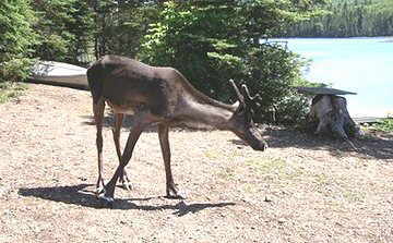
It was interesting to see wild animals at such close range. Ralph’s velvety antlers, big eyes and “high-heeled” hoofs were neat. The caribou that frequented our campsite (Ralph’s cousin) was just as casual about our human presence. We also had a red fox that came right into our campsite as we sat at the table one afternoon. Every day it checked the spot where we dumped the dishwater and then continued on its way, as if it routinely came across humans on its daily search for food. Due to the isolation of the islands we did not fear that the fox was rabid. It just seemed like the animals of the Slates had no reason to fear people. Bird life was well represented too. We often saw flocks of merganser chicks, herded along by a mother duck, and near our campsite there was a family of young hawks, which frequently could be heard squawking when the parents brought food. A variety of warblers, woodpeckers and chickadees would flit through the camp from time to time, and several loons and eagles were spotted.
At Copper Harbour on Mortimer Island, we explored an abandoned mineshaft located in a cliff face beside a narrow rocky beach. A small opening a few metres from the water’s edge led to a horizontal passage that went back into the rock for about 10 metres. Our flashlights revealed a tunnel about 4 feet wide and high enough to stand up in and, at the end, a pool of water. We had no idea if this was a flooded mine shaft or just a puddle, but no one volunteered to test it. There were no other signs of mining activity nearby and certainly no room on the small beach for any buildings, so we assumed that the ore would have been taken away by boat.
Another interesting feature was the caribou corrals built by the MNR researchers to capture caribou for their studies. On our last day I discovered one not far from our campsite and examined its structure. Built across a frequently used caribou trail which led to the beach, fences made of branches funneled the caribou into a palisade-like enclosure, where they could be held for study. The corral seemed to have a trap door type of entrance that would close behind the animal after it entered and another gate on the opposite side, probably to release the animal. Although the research is no longer being done, several of these old corrals remained hidden in the trees along the shorelines.
One day while the others were out paddling, Don and I decided to try hiking. We followed one of the caribou trails from our campsite through to the other side of island, and then followed a well-worn pathway along the water’s edge. At the end of the beach we found a caribou trail connecting it to the next beach and so we continued along the shoreline from one beach to the next. Along the way we collected interesting rocks and driftwood, saw tracks of caribou and foxes in the sand, and found three caribou legs. These, the remnants of a carcass, posed the question of cause of death – was it from winter starvation or predators? Eventually we ran out of beaches, and decided to try to follow a caribou trail inland. We soon realized it was impossible to follow the maze of trails that meandered around deadfall or disappeared completely in the thick spruce forest, and that it would be easy to get lost, so we bushwhacked our way back to the beach. A refreshing swim and a leisurely afternoon of reading on the beach seemed much more appealing.
Each day we would listen to the weather radio, wondering when our streak of perfect weather would end. After five days they began to forecast a change and we decided it was time for us to return to the mainland while the going was good. On Saturday we were up early and ready to paddle by 7 a.m. As our group paddled out from the harbour the morning sun sparkled like diamonds on the water and reflected off the paddles and I was able to take some of the most amazing photos.
After a pit stop at the tip of Mortimer, we started out. The lake was calm and the weather perfect for the long crossing. We could see the mainland in the distance and soon made out the smokestacks of the pulp mill at Terrace Bay, which I used as a landmark to keep me on course. For a while I was fascinated by the reflections of the other paddlers in the glassy water but soon I began to feel nauseous and had to paddle in the ripple of another boat to break up the mirror effect. It seemed forever, but two and a half hours later we paddled into the river mouth at Terrace Bay. Boats unloaded, cars packed, and off we went to the restaurant for the ritual of a final group meal together. Unfortunately we were too late for breakfast, but just in time for lunch.
Later that afternoon I looked out at the Slates from the car window as we sped along the highway, and I thought how my impressions had changed since the first glimpse of those mysterious islands exactly a week ago. At first the Slate Islands were just a speck on the map, and seemed somewhat formidable, they were so far out in the lake! Then when I first saw them in the distance I was surprised at how large they were. Now I could bring to mind hundreds of familiar images of this little paradise in the big lake. The Slates are definitely a Superior destination! (Sorry, I just couldn’t resist.)