
PADDLING WITH THE GHOSTS OF NORTHERN EXPLORATION
Ghosts of Northern Exploration
by Erik Antons
When you enter Nunavut, be prepared for an adventure beyond compare, in one the most scenic, historic and remote parts of the world. The Arctic Circle, at roughly 66 degrees N latitude, marks the northernmost point at which the sun can be seen at the winter solstice and the southernmost point of the northern polar regions at which the midnight sun is still visible in summer.
The hamlet of Pond Inlet, on the north coast of Baffin Island, is located almost 700 kilometres north of the Arctic Circle in a region that is blessed with spectacular scenery and a “summer” season that lasts for nearly six weeks. Pond is the home of the floe-edge, an area, where, every spring, the warm currents of the Labrador coast travel north along Baffin Bay, to reach the frozen Arctic Ocean, creating a narrow stretch of prematurely open water and a hyperactive food chain. From the microscopic plankton all the way up to the massive polar bear, the area is literally bubbling with activity. It is from here that visitors view that most mystical of whales, the narwhal, as it surfaces displaying its unicorn-like tusk for all to marvel at.
For years I had wanted to organize a paddling trip in the Far North. After producing several dogsledding trips to Baffin Island and the North Pole, our adventure travel company, The Northwest Passage, had become positioned perfectly to offer such a trip. The usual logistical problems existed. How would we get high-quality kayaks, equipment and food to such a remote destination? Could we count on powerboat support for shuttles to more inaccessible regions? Obvious concerns were also present. Would the water be at such dangerously cold temperatures as to be deemed off limits to all but highly experienced paddlers? Would we have problems with Polar Bears? It must have been fate when Dave Reid approached our booth at the adventure travel show in Chicago and announced that he had a fleet of new hard-shell kayaks for rent in Pond Inlet.
Dave Reid was a manager of the Pond Inlet Co-op, an Inuit owned cooperative which owns and operates the local store, hotel, fuel supply and just about everything in the hamlet. Originally from Glasgow, Scotland, Reid came to Canada to work with the Hudson’s Bay Company before taking his position in Pond Inlet. Reid had acquired all the contacts necessary for conducting a successful trip and we decided would co-guide an exploratory trip to Pond Inlet for The Northwest Passage.
During the 19th Century, the first of many non-natives passed through the Pond Inlet area. The first visit by a white man (qallunaaq in Inuktitut) is reported to be that of W.E. Parry, one of the foremost figures in Arctic exploration. Parry was one of the first to come in search of the Northwest Passage, a sea route believed to exist to the Orient through North America. Parry tried three times, unsuccessfully, to complete the route; he was stopped by ice on each attempt. Sir John Franklin also passed close to Pond Inlet during his ill-fated final expedition. Later in the century, as many as four other parties passed near the area in search of Franklin and his men.
English sailor and explorer John Ross had named the inlet after John Pond, Astronomer Royal, in 1888. John and his nephew James Clark Ross are credited with having successfully mapped much of Baffin Bay and King William Island and discovering the North Magnetic Pole during their journeys in the early 19th Century. The large island located 26 kilometres to the north of Pond Inlet, Bylot Island, is named after Robert Bylot, a survivor of Henry Hudson’s ill-fated 1610 voyage. Bylot accompanied William Baffin in 1615 to find open waters leading to the entrance of the Northwest Passage. While stopped short of entering Lancaster Sound by a large shore of ice, they achieved a farthest north record of latitude 78 degrees North, the farthest north of any explorer until the 19th century.
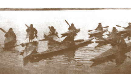
For our trip, I had solicited experienced paddlers through our newsletter and word of mouth. The trip was billed as a seven-day, six-night exploratory trip for experienced paddlers with cold weather camping skills. We found eight hardy individuals with varying degrees of paddling ability from as far away as Seattle and Boston. All had ordered the mandatory dry-suits and paddling mitts and were experienced in rescue and cold weather camping techniques. With all equipment and logistics in place, the stage was set for a successful journey.
We met for the first time the evening of August 16 in Pond Inlet. Most had flown up on one of the four weekly First Air flights from Montreal or Ottawa. I had flown up with Burt, a long-time NWT tripper and pilot in his Cessna 210. Our 13-hour flight was breathtaking as we soared above the fjords and glaciers that line the east coast of Baffin Island like teeth on a barber’s comb.
Following a comfortable night’s rest and breakfast at the hotel we loaded our kayaks and paddled from the shore. An iceberg had grounded overnight in the bay just outside of town, providing a beautiful landscape for photos. Its ultra pure white radiance was in stark contrast to the teal-blue fissures and folds that ran through it like streaks in a fine piece of polished marble. The crystal-clear sea was flat and calm as we launched under the curious gaze of Inuit children who had gathered around the brightly-coloured boats. A few fishermen glanced our way from their homemade plywood skiffs and a stray dog howled sheepishly as we left him on shore.
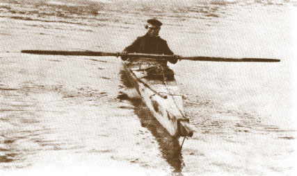
The water was surprisingly warm given our position north of the Arctic Circle. It felt like it was nearly 45o F, although I had no way of telling for sure. It felt like Lake Michigan in early spring, cold enough to take your breath away immediately, but sustainable for a few minutes at a time, given a dependable dry-suit and footwear. To experience the full force of the cold (and live up to a bet) I had subjected myself to a few Eskimo rolls the day before at midnight. The 24-hour sunlight provided a unique setting for a refreshing exercise in self-control.
As the village faded to our sterns, the coastline swept to the southwest and provided ever-increasing views of the sheer rock headlands and islands that lay a two-day paddle away. Everyone remarked about how distorted his or her sense of scale was. For instance, the mountains of Bylot Island appeared to be but 8 kilometres away. When we surveyed the map we found that they were almost 25 kilometres distant. According to the journals kept by early explorers, we weren’t the first to be mislead by our own senses. When the British Admiralty sent out its first naval expedition under John Ross to investigate three potential openings in Baffin Bay in 1818, Ross looked to Smith Sound and Jones Sound and quickly declared them closed. After sailing into Lancaster Sound he suddenly turned and headed for home, claiming that mountains had blocked his path. When W.E. Parry, Ross’s second-in-command, returned to Lancaster Sound in 1819, he proved that Ross’s mountains were, in fact, a mirage. Perhaps what Ross had seen, some say, were the 3,000-ft. peaks of Bylot Island rising directly from the ocean under the distorting rays of a low springtime sun.
As with any human-powered trip, the first day was the hardest. Perhaps what had taken us so long to cover the 25 kilometres to our campsite near Eqaperiaqtalik Point were the frequent photo opportunities along the way. Every stroke was another Kodak moment and the sun was co-operating with us wonderfully, offering rich beams and warm hues.
Tonight we would get our first experience with tundra camping. The rich, spongy soil provided a comfortable sleeping surface, but very little anchorage for the tents. Several nearby drainage ponds provided drinking water. Our landing beach was littered with whale vertebrae and other assorted bones, remnants of successful hunting trips by the Inuit. We heard the yips and howls of Arctic fox before stirring from our tents into the warm sunlight of the next morning.
After a quick breakfast of bagels, cereal, Missouri farm eggs (flown in on the Cessna) and coffee, we set out for the fjords of Oliver Sound. After another photo-op near yet another breathtaking iceberg, we made a five-mile crossing under calm conditions to Emmerson Island. Clouds had moved in later in the day, making for some slightly cooler temperatures, but the group handled this change in great fashion, landing at the gravel beach of another spectacular campsite.
Over night, a monstrous iceberg drifted into the sound within a mile of our campsite. This gentle giant come from afar, curiously gazing at us and we at him, each wondering about the other’s origin. A breeze had built during the night and small bumps could be seen on the horizon from the direction that we were intending to cross. We loaded the boats and set off for the point from which we were to make a 6-kilometre crossing. The group eased into the bigger waves and most paddlers felt comfortable in the 3-4 foot swells. While most maintained a comfortable ferry glide to the other side, others split off from the group and paddled directly for shore, taking the rollers along their beams. For one, the hour-long ordeal was touch-and-go, and for all, it was the biggest challenge of the journey thus far. The challenge was worth every bit of anxiety for as we turned the last point of the fetch, we were rewarded with the most remarkable view of the trip: a 15-kilometre stretch of 3,000 ft. jagged vertical rock walls rising directly out of the ocean and fading into the mist of a distant fjord, all unnamed peaks I was told later. The rest of this brilliant day was spent in the lee, covering a totl of just 15 kilometres to a hidden, remote sand beach at the base of a mountainous bowl.
 From 1880 to about 1900, whalers and free traders frequented nearby Albert Harbour, 27 kilometres east of the present site. Janes, a mate with Bernier on the Arctic, discovered what he took to be gold in the area in 1901, and a prospecting flurry followed; but like Martin Frobisher before him, Janes was in error. What did exist in the area were major deposits of high grade iron ore around Mary River, which was later to provide some employment for Fond Inlet Inuit when they were explored and staked in the 1960s.
Then in 1921, Gaston Herodier, a Catholic trader, took the Rev. Peck’s syllabic Bibles to Pond Inlet, and one man, Umik, began to preach his own version of Christianity. Janes, who had returned to the area after the First World War, was murdered, following some rather questionable trading practices. That same year, The Hudson’s Bay Company arrived and the RCMP set up a post at Pond Inlet.
Our campsite for our third night was a series of tundra terraces, extending up the bowl and into the mountains that surrounded us on three sides. I was to find out later that these terraces were formed from ice pressure over thousands of years. Apparently, the ocean was at different levels at different times in history and with each drop in its level, it left a terrace of loosely packed earth in its path. We were sleeping, eating, and playing on the earth’s growth rings.
We awoke the next morning to the sound of thundering surf below our tents. The tide had come to within two feet of our kayaks and cooking equipment, and another friendly iceberg had drifted near our camp. I playfully wondered if it, like the one the day before, was trying to tell us something. Something like, “I came floating from around the corner and I think you’d better stay in camp today with your little boats.” We fired up the stoves, made coffee, and settled in for a leisurely breakfast.
By late afternoon, the waves had subsided and we made plans for a night paddle to our final campsite 20 kilometres away. After dinner, we loaded the kayaks and launched into the calm waters toward Cape Knud Jorgensen. It was 8:30 p.m. If we were at home at this hour we would have donned headlamps, attached glow-sticks to our boats, established an elaborate count-off procedure and become thoroughly familiar with the chart before heading out into the water. Tonight we would wear Ray Bans and sunscreen.
This final paddle was a perfect ending to our journey for the following morning we were to be picked-up by powerboats for the return trip home. As the sun dropped just below the horizon and its beams shot toward us like long, lazy, embracing arms, an enormous full moon rose from our backs. It was then that I realized that those long lazy beams of sun were reaching far beyond our little group at sea, but around the edge of the earth that we were now a part of, and into the sky, space, and onto the surface of the moon. What a rare opportunity, I thought to myself, to he paddling at midnight under the sun and moon at the same time. I half expected the ocean to erupt into some kind of metaphysical hell, but all fell silent except for the sounds of our blades catching and recovering from the mirror-smooth surface of Eclipse Sound.
By midnight the temperature had dropped and we became chilled. One paddler had begun feeling seasick in the gentle rollers and all needed to relieve themselves after the four-hour stretch. When we beached at our site on Curry Island, several people had developed dexterity problems, which made unloading the kayaks a chore. By now everyone knew the drill: unload, consolidate all group gear, set up the tents, change from the dry-suits and fire-up the stoves. Once camp was set, we laid down for a much-deserved rest. The moon was full and the sun was on its way back up into the sky. It was 2 a.m.
Anglican and Roman Catholic missions were established at Pond Inlet in 1922. Most Inuit in the area continued to live off the land until the 1960s, and their way of life was recorded by the photographer/writer, Doug Wilkinson in 1953. In the 1950s four Pond Inlet families moved to Grise Fjord and Resolute Bay to assist the Port Harrison people to adapt. A school was opened in 1960 and a larger one built in 1966.
Today there are nearly 900 residents in Pond Inlet. Ninety-four percent are Inuit and the leading industry, other than government, is tourism. The residents refer to themselves as the people of the Toonoonik Sahoonik, which means, literally, the people from the land with the whale bone on the hill where the sun sets. The RCMP maintains a two-man detachment and the community health centre has a seven-person staff.
On the morning of Day Five, we awoke to cooler temperatures and slight winds. Snow had fallen across the sound on Bylot Island. We strung the antenna of our UHF radio and called in the powerboats from Pond. Several hours and three aerial flares later, two homemade boats buzzed onto the beach and we loaded the kayaks aboard for the two-hour ride home. Winter had moved-in overnight, bringing with it snow, ice, and overcast skies. We had lucked into a one-week window of nearly perfect weather.
Following a comfortable night’s rest at the lodge, we assembled for breakfast, exchanged comments and bid farewell. As we flew south, it wasn’t long before we began seeing trees, then roads and then cities. The nighttime approach to Chicago was a perfect grand finale to our journey.
Tonight I would dream of the Toonoonik Sahoonik, a pinpoint on the map, one of the most remote regions on Earth, home of the friendly icebergs, calm waters and thoroughfare for those early explorers in search of the Northwest Passage. I felt a kindred spirit that I didn’t detect when we’d left just 11 days earlier.
Reprinted from the Great Lakes Sea Kayaker, November/December 1997, newsletter of the Great Lakes Sea Kayak Club in Michigan.