
AROUND P.E.I. BY KAYAK
Cape Egmont…sculpted holes in the soft sandstone
by Wendy Killoran
I was blessed with tail winds throughout most of my June kayak circumnavigation of Prince Edward Island. As far as I knew, no woman had ever paddled around it. Epekwitk is the name the original Mi’kmaq inhabitants gave P.E.I., meaning “cradled by the waves.” I’d read an article by Maine long distance paddler Reinhard Zollitsch who talked about strong currents and treacherous points with chaotic water conditions when he made his circumnavigation. But day by day, the shoreline slipped by, steep red sandstone cliffs, endless sandy beaches rimmed by grass covered dunes and recently tilled red soil fields dipping to cliff edges, all with the friendly assistance of tail winds.
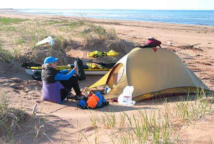
This was my first-ever solo expedition. Although I’d completed numerous expeditions, this time I would be not only self-sufficient, but also self-reliant. I had little choice when I arrived at Jean and Cecil Dunbar’s modest and hospitable Beachside B&B but to make a dash onto the Northumberland Strait. Upon my arrival at Cameron Point, Jean announced that she had a good case of the flu, and the entire cottage was in upheaval. I had no choice but to hastily pack my gear, change into paddling clothes and receive my first lesson in tidal fluctuations. I set out late, about 4:00 p.m., and it was low tide. I schlepped several loads of gear to water’s edge, and eliminated a few items at the last minute. Thankfully I’d rehearsed packing.
Sand shoals extend hundreds of metres into the strait and are home to numerous species of clams. At least three times I bottomed out and had to drag the fully loaded kayak into slightly deeper water. Soon enough, I hit deeper waters and let the wind and waves shove me westward. I travelled clockwise, and simply enough, just kept P.E.I. on my right with growing confidence.
As the sun sank lower, I had a dramatic view of the 12.8-kilometre long Confederation Bridge, its pillars resembling children standing equally spaced apart, holding hands. Warm hues of light hit the sinuously rippled sand shoals. I found a level campsite in the dunes, surrounded by trees, out of sight and away from homes on the leeward side of Bells Point, but three hours after my departure, it was still low tide. Tides in the Northumberland Strait are downright weird. They’re “mainly diurnal,” which means there are usually two high and low tides daily, but sometimes only one.
With natural endurance, and blessed tail winds, the paddling came easily to me, but the transporting of gear to my campsite above high tide, was always an exhausting exercise. With foresight, I’d sewn two large mesh duffel bags, which gobbled gear but stuffed into the size of a grapefruit, one into each hatch. It was my sanity saver and let me haul the gear and kayak in four or five trips.
The weather threatened rain on this first morning. Following a restless sleep where sounds seemed magnified in the dark of night, I listened to the blustery forecast on my marine VHF radio. I debated departure, but decided that as long as the winds were favourable, and within my personal comfort zone, I’d continue my journey. My watch had stopped ticking; this trip would take place without the regimented schedule of time told on a watch.
I departed at high tide. The earlier whitecaps off Bells Point were gone. I crossed a very confused Amherst Cove, as southeast swells from the previous day’s wind, collided with gusts of strong northeasterlies. All these waves and wind from the east, cancelled the strong currents under the Confederation Bridge from the west. I was being pushed westwards, but the kayak danced wildly with clapotis rebounding off Borden Point.
Gusts of northeasterly winds made me work to cross Salutation Cove and Summerside Harbour. At MacCallums Point, two shell fishermen snorkelled in wetsuits, gathering oysters from the shallow bottom which they tossed into floating baskets tethered to their waists.
Arriving west of Summerside in threatening weather, I carried my belongings to a flat, grassy spot near an abandoned, decrepit concrete wall, which looked like the local hangout for beer drinking and bonfires. I was too tired to move elsewhere. I needed to visit Summerside the next morning, as hopefully, a new bent-shaft paddle would be waiting at general delivery.
I picked up the paddle and completed several other errands – got water at the marina, had a Tim Horton’s breakfast, used an ATM and purchased more cell phone time. It would become more challenging to do any of these things elsewhere along the shore. Summerside and Charlottetown are the only cities on P.E.I.. Hereafter, I’d visit only small fishing villages with limited facilities.
Again, I didn’t sleep well. Through the wind and rain pattering loudly on my tent, I heard an anonymous, mysterious cough. Why would anyone be out in the bushes on a cold, stormy, wet night? I vowed to find better campsites thereafter where I would feel secure.
Many people had commented on my bravery when I told them of my trip, but in actuality, I feel secure and at home on the water and in my kayak. My greatest fear was not water-related because I’d vowed not to put myself in risky situations. My greatest fear was the thought of being visited by some ill-intentioned, uninvited character under the cloak of darkness.
Mirror calm waters beckoned me as I crossed from Ives Point to Sunbury Point in Bedeque Bay. Hundreds of red-billed black scoters swam away as I approached. I saw a bald eagle, and my first seal bobbed curiously with its sleek, shiny head out of the water. I was surrounded by a profusion of pelagic birds with their distant, mournful wails.
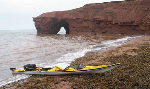
Near Mount Carmel, a cormorant dove under the water. I nearly had a heart attack when it resurfaced just as my paddle blade was about to scoop it. At Cape Egmont, an Acadian region of the province, calm conditions allowed me to easily round the rocky headland with sculpted holes in the soft sandstone.
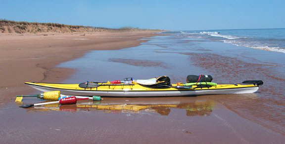
At Maximeville, I came ashore near the tip of a sand spit. Shallow sandbars along the coast can create a wall of crashing surf, but calm conditions made for a relaxed arrival.
It was easy to dry out my damp gear as an evening wind picked up. I had seen very few people outdoors as I paddled, looking from the outside edge of the province inwards. A satisfying solitude surrounded me.
I’d strained the muscles in my right wrist just prior to my P.E.I. paddle. Now my right arm was very sore and swollen. Thankfully the bent shaft paddle alleviated the strain, and I continued to make good daily progress. It was the camp chores which aggravated the injury. I found it quite incredible how small increments of progress added up to produce noticeable distance on a map. I made it part of my routine to mark on my map my daily campsite location.
With quiet lapping waves, and a foggy, cool day, I departed Maximeville well rested. I’d obtained water from the cafeteria in the town’s fish processing plant. All eyes stared at me as I filled my two bottles, dressed in PFD and sprayskirt dangling to my knees.
At Rocky Point, where half a dozen seals eyed me, I decided to cut across calm Egmont Bay to buildings visible on the distant shore at Brae Harbour. I fell into a rhythmical cadence, into a trance. It was a 14-kilometre crossing. At one point, I knew that the nearest land would be seven kilometres distant. It didn’t bother me. A few waves played from the port beam, but then the calm would return.
I followed the sandy shore along the northern edge of Egmont Bay, but was shivering from having stopped, and had lunch on shore. My fingers were wrinkled prune-like from being wet all day in neoprene gloves. I arrived at West Point, hopeful of bedding down in a room at the prominent black and white striped West Point lighthouse, but rooms were not available for another week. I was visiting in the off season; P.E.I. caters to tourists mainly in July and August. To my delight, however, I found a spacious, second-floor suite available above the Harbourfront Community Centre, overlooking the dunes and tranquil harbour.
Soaking in an oversized hot Jacuzzi tub was pure luxury. Maps were strewn to dry over the furniture, as water had leaked into my half-open map case. I rehydrated, without fear of over-using the fresh water. I fell asleep to the whoops and bantering of a party in full swing below me.
Dawn arrived in a hushed calm. I was relieved to find my kayak still safely parked in the dunes. It was also a relief to round West Point under such placid conditions. Much of the western shore of P.E.I. is vertical, red sandstone cliffs. I could not squander this opportunity by staying an extra day in the luxurious harbourfront suite.
Kilometres of cliffs passed slowly by as holes of blue sky poked through the somber clouds. Colonies of cormorants nested on the minuscule ledges. And though the Northumberland Strait remained calm, with the current flowing against me, gusts of wind unnerved me. The salty smell of the briny water invigorated me. It brought back fond childhood memories of spring holidays spent along the seashore in South Carolina.
My confidence continued to grow, as conditions remained fairly calm. My mind remained uncluttered, focused on the present, on my surroundings, without the distractions of work and home life. I gazed at the ever-changing textures of the water, a pearly grey satin with distorted psychedelic blobs, which obliterated into ripples as gusts puffed over the surface.
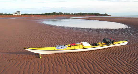
The cliffs were beautifully eroded. The soft red sandstone, rich in quartzite crystals coated by the mineral hematite, which oxidizes into the rusty red colour prevalent throughout the province, was sculpted into arches, columns and small caves. It was easy to imagine the fury of a November gale racing across the strait, hammering away at the soft base. I realized that if I’d waited a decade, the circumnavigation would theoretically be a shorter distance, as on average, about one metre of shoreline plunges into the water annually. Looking over my left shoulder to the southwest, a thin, grey line hovered on the horizon. It was the province of New Brunswick.
As afternoon arrived, so did more splashes of sunshine. Immediately, everything appeared more saturated in colour and more friendly. I’d wanted to stop at Miminegash, a town where Irish moss is harvested, but the flow through the harbour walls intimidated me. I would have to leave with an ebbing tide, so I continued on to just north of Cape Gage, where I camped on the beach.
An old blue pick-up truck came bumping down the beach as I toted my duffel full of gear. I had the pleasure of meeting Gussy, a man weathered from decades of hard, outdoor work, who was on an evening drive down the beach. He offered to bring me a four-litre plastic jug of fresh water. Later, while I was cooking dinner, he returned with the water and a wealth of local knowledge that he was pleased to share.
Dawn was glorious. The Northumberland Strait was as flat as a mirror and a surreal, pale shade of lime-blue. The sea melded with the sky on the horizon. I felt great joy and comfort going through my morning routine under such a cloudless, blue sky. I needed a day like this; I’d arrived cold and wet on this beach. It boosts the morale immensely when Nature shows its kinder, gentler side.
I departed near high tide. It felt glorious to be paddling along the P.E.I. coast in such calm conditions; quite an anomaly, as North Cape is home to the Maritime’s largest windmill farm, which provides 8% of the province’s electricity. I’d been warned that there’s a reason that this wind farm is located where it is: it is usually very windy at North Cape.
As the sun climbed higher, a north wind started to blow, a headwind. Rounding Horse Head, some twenty kilometres from North Cape, I could already see the light from the lighthouse and the windmill farm. I noticed snow geese migrating northwards. I’d seen them over a week earlier resting along the south shore of the mighty Saint Lawrence River near Montmagny by the thousands.
I had to work to reach the third milestone of my journey, North Cape, with the moderate headwind. My first milestone had been the launch of my first-ever-solo expedition (a psychological milestone). Rounding West Point had been the second milestone.
Guillemots flew low over the water and some common eider ducks rested on low rocks. Near North Cape, caves, spires and arches held my interest. Elephant Rock had succumbed to the forces of nature in 2002. The water was a deep shade of jade green under such a brilliant sky.
Miraculously, the wind disappeared and high tide was just starting to ebb as I reached the reef at North Cape, reputed to be the longest reef in North America. I glided across within metres of the shore, with barely a tug on the kayak. I pulled my kayak up the beach on a soft, slippery bed of seaweed, lunching on a massive seafood platter at the Wind and Reef restaurant. Ironically, neither wind nor reef would challenge me on this idyllic day.
The remainder of the day stayed calm. A frenzy of lobster boats rumbled off shore. I’d entered lobster season when I’d rounded North Cape.
Fanciful rock formations excited me as I now paddled southwards. Near Anglo-Tignish, two fellows sitting on a cottage porch looking out over the Gulf of St. Lawrence waved. I was starting to wonder where I could set up camp. Cliff and Larry, two friendly golfing buddies from New Hampshire, let me camp on their pebble beach. What a relief to be away from the invasive sand particles. It was also very convenient to climb the stairs and be able to obtain fresh water.
The thrumming of engines awakened me at the crack of dawn. Dozens of fishing boats plied the water even before the sun had appeared. I enjoyed a calorie-rich breakfast and animated conversation with Larry and Cliff, and got a drive to the nearby Co-op store in Tignish to obtain groceries and medication for my inflamed right arm.
Conditions were again favourable, and I made a late departure, near high tide, under sunny skies and calm waters. How was it possible that favourable conditions accompanied me day after day? Did the Great Manitou look over me in his Earthly Paradise like he’d done on my Manitoulin Island circumnavigation?
I chose to not wear my drytop for the first time on the trip. It was only the second time in the trip that I wore sunglasses. I realized that I was enjoying very much spending time with myself. I’d given so much of myself to others, my family and an extremely needy class of fourth graders; now, I was giving to myself. It was therapeutic and necessary.
The Cape Kildare area was an area of wondrous cliffs, with rock eroded into caves, arches and pillars. Swallows nested in holes at the top of the cliffs. Kingfishers flew ahead of me, chortling loudly. I pulled ashore to clamber through these pillars and holes.
Jacques Cartier Provincial Park is named after the early European explorer who is believed to have landed here in 1534, proclaiming it as “the most beautiful stretch of land imaginable.” Even now, travel magazines rate P.E.I. among the top ten islands worldwide due in part to the fine beaches, which now lay before me for over 40 uninhabited kilometres. Endless sand dunes and beaches that steamed from the sun’s heat slowly passed by. As far as I could see, dunes faded into the horizon.
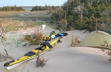
I decided to camp on an island known as Conway Sand Hills, in a sandy dip in the dunes adjoining the beach. The dunes themselves are too fragile to camp upon, and the grass is spiky enough to puncture tent floors. A glorious day quickly transformted into a chilly evening as a red orb descended in a cloudless sky, unable to cling onto the warm colours of day’s end.
Again, the drone of fishing boat engines woke me in time to watch the sun rise over the Gulf. Unbelievably, slight tail winds continued to urge me to make substantial progress albeit with a moderate surf launch. With favourable conditions predicted for the remainder of the week, I felt optimistic that the exposed North Shore would see me safely to East Point.
Hog Island, comprised entirely of sand dunes, undulated on my starboard beam and fishermen checking lobster traps floated on my port beam. Below my kayak, I could see sinuous ripples of sand in the shallows, snaking across the sandy bottom and a scuttling crab.
Not only was the westerly breeze in my favour, but the current also flows west to east along the North Shore as the Saint Lawrence River flows into the Gulf of Saint Lawrence. I paddled along with the swells as they lifted me hypnotically. I was covering extensive distances daily; I wondered if it was to please myself or to impress others.
Near the eastern tip of Hog Island, a fishing boat headed directly toward me. I always worried whether I was clearly visible to these fishing boats. But the Sparkling Crystal stopped a safe distance away and we exchanged friendly hand wave greetings.
Crossing Ship Channel at the mouth of Malpeque Bay, known for its oysters, a satin expanse of jade green water enticed me to cross the four kilometres. Finally at Profitts Point, red cliffs replaced the sand dunes. Cliffs and beaches alternated. I rounded imposing Cape Tryon in calm conditions but felt the tug of the rising tide into New London Bay.
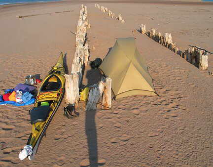
I camped on a speck of an island covered in sand and the remains of two separate piers, one fairly intact and another with the ghostly skeletons of sun-bleached wooden pilings extending towards the western park boundary of Prince Edward Island National Park. It is Canada’s smallest, yet third busiest, national park and protects more than 40 kilometres of shoreline, both beaches and cliffs, which are eroding away into the Gulf.
A stiff southwest wind accompanied me along the national park as I paddled eastwards. I decided to land at the campground but discovered that it was not open this early June. Gusts of wind grabbed me as I rounded Cape Turner. I parked my kayak on a beach at North Rustico Harbour and walked along a scenic boardwalk into the Acadian fishing village where I restocked my depleted food supplies and purchased some hand-knitted woollen gifts.
Continuing on, I surged eastwards along the park’s shoreline and found a sheltered trough in an inaccessible dune north of Tracadie Bay. It was a lovely campsite and I watched a red sun sink below the gulf. My self-assurance was growing daily. I felt empowered.
I started in a moderate westerly wind from the eastern extremity of P.E.I. National Park. Beautiful homes lined the shore near Savage Harbour and a perfect green lawn flowed towards the beach at The Links golf course. Erratic water and wind gusts required all my focus to cross St. Peter’s Bay. I was being pushed eastward rapidly in increasing wind and waves and decided to get off the water at Naufrage while I still felt comfortable.
I visited the Shipwreck Point Café, where good food and friendly service had me debating my options. A few hours later, I departed with strong westerlies pushing me effortlessly eastward, past St. Margarets Bay and Clear Springs until I feared I would not find another beach before sunset as endless cliffs lined the shore. A small cove appeared near Hermanville and without hesitation I landed, surrounded by cliffs but also a beach that extended beyond the high tide.
I anchored my tent with massive red sandstone boulders. When I’d emptied the kayak, the wind tugged at it, so I anchored it with boulders as well and then built a windscreen cooking. At night, the tent shook and shuddered in the wind, sending blasts of sand through the mesh, sprinkling my face and invading my ears and nostrils as I tried to sleep. I ducked under my sleeping bag liner to avoid this invasion of sand.
By morning, the wind had subsided. A glowing red ball ascended a murky sky and dozens of fishermen were checking traps. I paddled into a diverging golden trail of scintillating light. The southwesterly breeze had changed to northwesterly, a cool tickle on the left side of my neck. And then a calm ensued. A change was stirring.
Near North Lake, the fishing boat Daddy’s Girl puttered towards me. The captain gave me a small lobster, which I bungeed to the foredeck. I paddled away with a huge grin and my supper back staring at me.
Along the entire north shore, I’d had a feeling of urgency to reach East Point, where a shallow rock reef extends far from shore, and where the Gulf and Northumberland Strait currents collide. The north shore of P.E.I. is fairly straight and very exposed to an enormous fetch across the Gulf of Saint Lawrence. I felt vulnerable but now approached East Point with calm assurance. A hushed quiet made reaching another milestone easy. I paddled within three metres of the cliff, barely feeling a slight wobble over the reef.
No sooner had I rounded East Point than a northeast wind began to blow, pushing me southwest, past kilometres of dunes and beaches. A hummingbird unexpectedly zoomed by.
I had planned to stop at Red Point Provincial Park, one of the few parks open this early in the season, but continued on, as the thought of carrying my kayak up steep wooden stairs to the top of a cliff, solo, was intimidating.
Half a kilometre beyond, I found an idyllic campsite, on a sandy beach sheltered beside a sandstone cliff, facing the western sky and a three-kilometre sweep of empty beach. Gannets screeched and plunged, folding wings back and sending a spray skywards, as they dove.
I cooked my lobster in a pot of seawater. It was a spectacular evening and sunset. I saw the Magdalen Island ferry pass by and could see Nova Scotia to the southeast on the horizon. Though my blisters, cuts, and back and arm muscles ached, it was all worth it; I felt so joyfully alive.
A magical light filled the eastern sky as I awoke, a deep steel blue cloudy sky fused with the Strait’s horizon. I packed hastily; for the first time the tent was not soaked by dew, but drops of rain were starting to fall. A tinge of pink streaked across the ominous-looking sky. I felt tranquil. The urgency I’d felt the previous days was gone. North Cape and East Point had loomed in my mind as places to fear; yet they’d been easily negotiated. It had taken exactly a week to paddle from West Point to East Point; my progress astonished me.
I paddled past many points, crossing bays in calm conditions with hypnotic light enchanting me. From Souris Head, I crossed Rollo Bay to Howe Point, then to Durrell Point and Spry Point. Lately, when on land, I had the sensation of being rocked by the water.
The water’s texture mesmerized me. Dark clouds with glowing light from the east made cobalt blue lines slither over the liquid silver. I paddled with a calm, steady and effortless cadence. I felt like I was flying over the water. The quiet was profound and pervasive: no bird calls, no boat engines, no surf crashing ashore, only the occasional fisherman’s voice floating over the water. I heard the drips of my paddle strokes and noticed whorls as I pulled my paddle. I was entranced. I saw the beauty in the simplest of things. The reflections of colourful buoys flowed like an accordion playing and, when seen at the precise moment, formed an exact mirror image.
The sun arrived as I paddled across Boughton Bay to Launching Bay. I crossed the rocky reef where at least two dozen blue herons were fishing stealthily. I continued around the eastern and southern shore of Boughton Island, where numerous seals followed me through the shallow boulder-strewn water and frilly seaweed undulated below me.
I landed on the western shore of the island, on a sandy beach in the lee of the wind, which was now blowing. I camped at the edge of a fir forest on a carpet of bunchberries, overlooking Cardigan Bay as the evening light blazed the nearby sandstone cliff in fiery light. I fell asleep to the sounds of seals at play.
The last two and a half days of paddling continued to be favourable. I camped at Northumberland Strait Provincial Park, and met a new challenge, I carried my kayak up the 26 steps to the top of a cliff. At Point Prim, with its shallow, extended reef, a calm once again arrived, and I paddled across Hillsborough Bay, feeling the ebbing tide suck me towards the Northumberland Strait. Camping near Rice Point, I accomplished my final paddle to Cameron Point easily.
As I entered the bay, I saw the Beachside B&B and Jean come outside to sit on her deck, chatting on her phone. I waved. Incredibly, her daughter asked, “Is the kayak woman back yet?” and Jean looked up at that moment, answering, “I see her now, ” as she waved back at me.
Wendy Killoran would like to thank her supporters and sponsors. In particular: Stright-MacKay/Waypoint Chandlery, in New Glasgow, Nova Scotia, provided the VHF radio and all necessary nautical charts; and Current Designs (Wenonah) provided a new graphite, bent-shaft “Feather” Cadence paddle and several accessories. Also, thank you to Glenn MacKay and family for providing support.
Incredible article. Read the whole thing with pleasure as I am currently planning the same trip. Thank you for your words.