
Mary Cavanaugh
Our departure time was planned for 6 a.m., however one member thinking that they may not be able to shower for a week or so, decided they should take the extra time now to do this important thing, delaying our start time. Had they known we would be in continual rain for the next two days on our way to Silver Islet, they perhaps would have realized they would have several ‘showers’ in the next few days.
Saturday night was spent at one of our favorite haunts – Naturally Superior Adventures where David Wells welcomed us and where we enjoyed dinner in the large eating area looking out to Michipicoten Island. That evening a couple of us went picking blueberries and easily filled our four-quart baskets in an hour or so. Our tents, without the flies, were set up in the two yurts and an early departure planned for the next morning.
On the way to Silver Islet, we stopped in at Superior Outfitters Coastal Kayaking Adventures at Rossport to confirm our shuttle arrangements with Dave Tamblyn (brother of Ian). Late in the afternoon we arrived at Silver Islet and even in this tiny rustic charming spot, it took us a bit to locate the B&B where we were scheduled to camp for the next two nights.
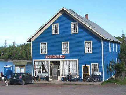
Silver Islet in the 1870s was a mining community, where from a small offshore island, fortunes were made and millions of dollars in silver were extracted – $3.25 million over 14 years. The Saxberg family acquired the store in 1988. They continue to restore it to its original condition. If you enjoy homemade soup and pastries, visit the Tea Room located at the back of the store overlooking the water. Along the shore, against high cliffs are miners’ cabins, now beautifully restored. We enjoyed our stroll along the shore during the evening and our paddle out to see Sleeping Giant, the Sea Lion, Tea Harbour and the famous island during the day – but came back without any silver in our pockets!
With the shuttle accomplished, we put in at 2:30 p.m. and left for Horseshoe Cove, crossing Black Bay to Black Bay Peninsula. Calm waters made for a beautiful paddle. That evening a couple of us paddled out to the lighthouse at Porphyry Island and who did we meet on the way back but Joanie and Gary McGuffin. They, along with two other couples, were canoeing in lovely spray-deck covered canoes and testing out new tents.
On the water shortly after eight the next morning, we headed for Number 10 Island passing to the north of Magnet Island and Longin Island. Some of the group decided to set up their tents near the Number 10 Island Lighthouse, however there are a zillion ants, ant hills and ant tunnels at that spot and so a couple of us set up on the shore. We found out that the Number 10 Island ants attract unusual warblers such as the blue-winged, golden-winged, prairie and the hooded. (The Thunder Cape Bird Observatory is located at Thunder Cape at the tip of Sleeping Giant.) Rain, wind, thunder and lightening kept us camped at Number 10 for the next two nights and we enjoyed the sounds and sightings of the warblers and magnificent rainbows in the sky.
It was an early 5:45 a.m. wakeup and we were on the water at 7:20 hoping for calmer waters. It was a gorgeous sunny morning and the lake was smooth! We headed for Swede Island and the sauna. A breakfast on the picnic table and then we let the wood stove in the log building for our sauna. We could hardly wait! We so enjoyed the sauna and the quick dips into the cold waters of Lake Superior! Our camping spot for the evening was Loon Harbour on Spain Island.
Some of us paddled around Spain Island in the late afternoon and others of us paddled down the channel located on the east side of Borden Island in the evening. It is a scenic area with the island giving us lots of protection.
The next morning brought more calm water as we headed along the west side of Lasher Island enjoying all the loons and some exceptional loon calls. We expected some very young ones not too far away. It was onto Roche Debout Point where the landing is not an easy one, lots of tiers and stones! Later, three of us headed out to see if we could locate the waterfalls at Otter Island; but no luck. As we paddled farther down Otter Cove we realized the waterfalls is located at the far, far end of Otter Cove, not Otter Island. Due to the time, wind and waves, we decided that we wouldn’t be able to make it to the falls. On the way back, just about a kilometre from our camp site, standing right out on the rock and not in the bush was a huge bull moose, hardly a hundred feet from us. He eyed us for several moments while the three of us got mega camera shots of him. Mind you with the excitement, wind and waves, some of the pictures are of just rocks or feet of the moose!
The following morning, three of us were up early and determined to locate the falls. Getting closer to the falls area, a family of otters kept popping up to check us out – quite a sight to see. After walking up stream, we found the spectacular bridal falls; it was certainly worth the effort to locate!
The group headed out for Spar Point where the McGuffin Party was setting up and where we had lunch. We paddled on to Fleur Island (Fluor Island? Ed). As the southeast winds were picking up, and the sky was darkening we went up along the west side of Fleur with its high, high cliffs. Locating a campsite was difficult and the first few raindrops had begun to fall. We ended up camping under the boat warning lights at Black Bay Peninsula, just before Blind Bay and Nipigon Strait. The tents and the tarp were set up in the rain and everyone was tired. Dinner was a late one at 7:30 p.m. and it was an early evening for all.
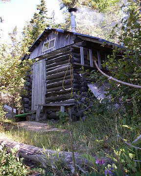
We were on the water at nine the next morning. No rain, calm waters but lots of cloud! We were off to Squaw Harbour located on St. Ignace Island and another sauna. No time was wasted starting the wood stove for the enjoyment of this sauna. This is a popular spot for pleasure craft and sailboats and there were four moored at the several docks. We were happy that we paddle sea kayaks though, as we watched one boat having to take fifteen minutes to get off a shoal that he had landed on, on the way into Squaw Harbour. After dinner we did a fabulous 45-minute hike up a moss-laden trail leading high above the black spruce treetops. Part of the trail includes three sections where you use ropes to help you scale up the steep rock face. The fog was heading in, thick and fast as we headed back and into the tents for the night.
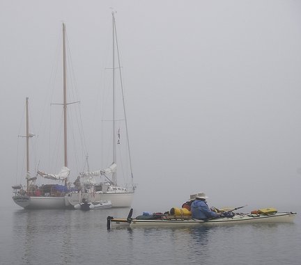
Next morning the fog was thick, very thick; so thick that the boaters couldn’t believe we were leaving for Agate Island Provincial Wilderness Island. However, we set a GPS and paddled into a small bay at Agate Island. Two sail boaters woke up to five sea kayakers paddling by. We picked up some interesting rocks and then head out for Paradise Island in the thick fog. We set up camp on Bowman Island just northeast of Paradise Island.
Paradise Island is formed entirely of layers of pink gravel covered with moss. It’s a protected island, on which camping is not allowed. While hiking the path through the centre of the island, we were amazed at the number of tiers, which just go on and on.
The camp (home) of the deceased lighthouse keeper of Talbot Island is located on Bowman Island. He is buried here with a white cross at the head of his grave. Several fresh wild flowers filled the can by the grave marker. We were told a sad story of his life here and the life of lighthouse keepers of Talbot Island.
The fog continued – thick! With our GPSs set, we headed off to Dupuis Point, along to Fraser Point and McNab Harbour for a lunch stop. There was some sun at lunch but back on the water the fog was thick, so thick that it was hard to see the shoreline and we had difficulty locating St. Joe Islands. Thank goodness the GPSs were set. That evening we hiked along the island looking for amethyst in the black lava, but had no luck in finding any.
Next morning the fog had lifted as we headed for Grotto Point, Woodbine Harbour and lunch at McKay Cove. Once again the fog began to thicken and the wind picked up as we headed for Raymond Island and camp at Morn Harbour. Sometime we couldn’t even see Raymond Island from our campsite at Morn Harbour (which is only a short distance away) due to the thick fog.
Next morning brought sun, blue sky and very little wind. It was a wonderful day as we paddled across Simpson Channel to Harry Island, and along to Minnie Island. It was across Wilson Island, southeast along Quarry Island and into Rossport Harbour and we were there! Dave Tamblyn greeted us as we touched shore.
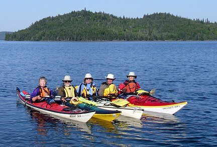
Three of us have now done four sea kayaking trips on Lake Superior and it is an amazing place to paddle and experience the wilderness. To see animals such as bald eagles and their nests, falcons, warblers, loons, otters, moose, fox, and several kinds of ducks, not to mention the many arctic flowers, is a real treat few of us get to experience.
Mary and her group made this trip from July 14 to 29, 2007.