
by Rob Muylwyk
 I was looking to my right, scanning the shore for a suitable campsite, ideally one with Brian camping on it, when I suddenly saw a huge, hardly submerged rock in my peripheral vision. It was right in front of me, about a paddle stroke and a half away! The adrenaline kicked in, I put the brakes on and started back-paddling like a “little engine that could.” This was successful; there would be no new gashes to be repaired in the off-season, but my imperfect back paddling technique left me with my bow pointing to where I had come from. I had been heading into the 25 knot westerly, so now I had to start to get my boat turned around again. The theory says that kayaks will weathercock, or turn into the wind, all by themselves, but in real life I had to power sweep to get back on course, while trying to evade the rocks that kept popping up all around me.
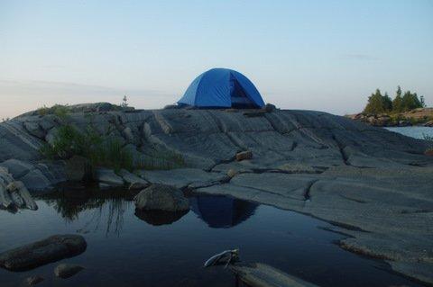
I had signed up for Šárka’s “Minks and McCoys” trip this past summer, which was scheduled to start the following morning. She had subtitled this trip “the long way” as we were to put in at Snug Harbour rather than at Dillon. I had opted for a head start by putting in the afternoon before, necessitated by the four hour drive to Snug, with the goal of camping out on Henrietta Point. Brian was on his way there as well; he would paddle the long way from his cottage. A wind warning was in effect, but at the sheltered, sunny put in things looked just fine. I had lots of time so I took the scenic route out, along the east shore of Snug Island, then through the narrow channel and around the top if the island to start the still sheltered southwest crossing of the Shebeshekong Channel to the south coast of Franklin Island. I was fully exposed to the west wind once I came around the southern point of Franklin, with conditions getting gradually worse. So when I noticed a nicely rounded granite knoll with a tent ring of boulders on it, I decided to call it a day and turned into the sheltered bay adjacent to it. After setting up camp I used my map-less GPS to plot my location on the topo map to find that I was actually just a few hundred metres east of Henrietta.
I set up the kitchen a good distance from my tent, in an area where I could sit on a rock while tending to the cooking. This is proved to be an awkward position, and it caused me to topple my boiling pot with noodles all over the only section of the otherwise bare rock that had earth, leaves and small bugs. As I stupidly hadn’t brought extra food – even though I had decided to always do that after potentially running out of food on an earlier weekend, stormbound for what could have turned into an extra night or more – I had no choice but to rinse each and every individual noodle. And of course, these were not nice straight fettuccini noodles, no; I had opted for rotinis, with all the dirt caught in between their tiny grooves! After enjoying a delicious, albeit still a bit gritty meal, I cleaned up and set down on a rock overlooking Georgian Bay, waiting for the sun to set out of my view. As I hadn’t been able to rendezvous with Brian, this had become my first paddle-in solo trip, so how appropriate that the book that I was reading on this rock was titled Solo.
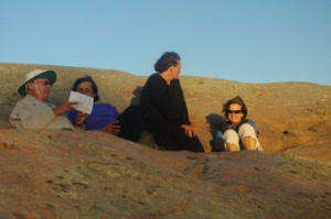
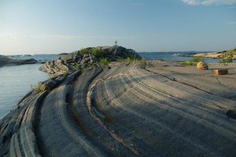 The next morning I woke up before the sun did so that I could use the early light to try to take some photographs of the striations and long wavy shapes of the mostly gray and black twisted granite. After breakfast I clambered over the rocky shore around the couple of inlets separating me from Henrietta Point, where I found Brian enjoying his breakfast. From here we had a good look over the wild water that we were supposed to paddle, as our intended route would take us west from here to Red Rock then North West along the Mink and McCoy Island chains. After listening to the marine forecast and decoding the MAFOR codes we knew that we were in for another 20 plus knots day, and we decided to recommend to Šárka and the rest of the group to take the inside passage east of Franklin instead. Close to the arranged meeting time we paddled east to meet the group before they would unnecessarily start their way along Franklin’s south, and just when we were about to land on the southeast point, the bows of Šárka’s, Laura’s and Susan’s kayaks popped around the corner.
All agreed to take the sheltered route, so for the next 7 kilometres we paddled easily on the calm waters of the Shebeshekong Channel along Franklin’s east flank, until we rounded Galna Island at the top of Franklin and were greeted by the hard blowing headwind out of the west. From here on it was a matter of digging in deep and persevering, as we slowly but surely made our way towards Rocko Island where we stopped for a well deserved lunch and for some a swim. As if they were part of a parade, a group of White Squall guides and clients paddled by in single file, en route from Dillon to Big McCoy Island. Looking at the exhausted paddlers, one being towed, and knowing about the conditions out on the Bay, we were betting that we wouldn’t see them there.
Back on the water we tried to hide behind wind sheltering islands as much as we could but a blocked passage between the mainland and an unnamed island east of Fairhead Island was the last and failed attempt at that. From here on we faced the strong wind again for a 6-kilometre crossing via Twin Sisters Island. Although the wind was strong, the waves were well behaved and non-breaking, so the slower paddlers suggested that it would be best if everybody just paddled at his or her optimal speed. Eventually all made it to the sheltered campsite halfway up the east coast of Big McCoy, where we rested, swam and sunbathed before setting up. There was lots of space for all of us, but it might have been crowded if the White Squallers had made it.
After hanging out around a table put together from granite slabs and trying to fit our five cook stoves on it for the individual preparation and consumption of our dinners, we walked over to the other side of the island to take in the sun set. This walk included a large tract that showed obvious signs of a severe forest fire that must have taken place here a number of years ago. Apparently some blame careless kayakers for that, and maybe it became the main reason for the current voluntary fire ban on the islands. While the sun did its glorious setting, Brian explained the MAFOR system to us. MAFOR is transmitted on VHF weather radio channels as an alternative to the verbose weather synopsis. The codes are usually easier to understand and they provide more detail, including hour to hour changes, but one must write them down and decode them afterwards using a simple guide. Once you understand how to do this it becomes an easy and very worthwhile chore.
The next morning Brian did his MAFOR thing again, and now we were faced with the dreaded wind reversal forecast. It just doesn’t seem fair to have headwinds on the way out as well as on the way back! Since the reversal was forecast for noon or later, we decided not to linger and pack up and go right away. The wind was still out of the west and though light when we started out, it soon picked up. We paddled along the outside – along the west shores – of the island chain. The scale of these islands is small, most of them hardly stick out over the water, but with a bit of imagination the very steep red rocks of Dart Island and others make them look like very high bluffs. With the waves echoing back from these shores it was fun to try to paddle by as close as possible. At Elmtree Island Brian decided that he should get ahead and on his way to his far away cottage, so we said our goodbyes. It didn’t take long for him to disappear out of view!
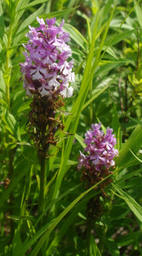 We stopped at Green Island for a snack and a walk around the island. This island is very beautiful, with many large white pines and black spruces (or so I think, because my tree recognition skills are non-existent). There are also a few very nice campsites, of which one includes elaborately built tables and benches, comfortable maybe, but it certainly takes away from the wilderness experience. I know a lot more about orchids than trees, so my day was made when we stumbled on a colony of small purple fringed orchids (Platanthera psycodes) with the top half still in flower. Šárka’s day was also made, as she found lots of berries to munch on. We also admired a large empty snake skin. Perhaps the most intriguing part of Green Island was a number of steel stakes driven into the rock. Apparently this has to do with a commercial fishing station that operatedl here a century ago.
Continuing on from Green we stayed on the outside of the Minks, all beautiful islands without cottages until Stalker Island and the ones south of it. Eventually it felt a bit like paddling through people’s backyards, until we finished crossing eastwards getting ready for the 5-kilometre crossing to Henrietta Point. The wind direction had not yet reversed, so we made good time to the Point, where we took out for a lunch break. It was lunch with a view, a very wide and clear one which took in the full chain of the Minks and McCoys that we had paddled, as well as the huge Red Rock lighthouse and the Snake Islands. Then when we looked down at our feet we had another great view, that of the interesting forms and colours of granite.
 On our final leg from Henrietta back to Snug Harbour we paddled along and chatted with a group of canoeists, who skilfully propelled their fully loaded boats through the waves. There were a lot of boats taking out at Snug, but eventually we ended this great trip with an enthusiastic group hug. Thank you, Šárka, for another great trip. This was my first visit to the McCoys, but I’m sure I’ll be back, never mind the four hour drive!