
This park, located at the tip of the Bruce Peninsula, is the perfect location for a multi-day trip where the paddler can explore the many islands making up the park from a base camp on Flowerpot island, the only location in the park where camping is permitted. Shorter day-trips involving visits to any of the islands nearer the mainland are also possible.
The rewards for the kayaker visiting Fathom Five are many: the majestic flowerpots of Flowerpot Island, the spectacular cliffs of Castle Bluff, the fascinating wave action caves (now perched many metres above Georgian Bay) on Flowerpot Island, the small sea caves on North Otter Island, the picturesque inner-island waterway between Williscroft Island and Cove Island, a number of shipwrecks, the historic lighthouses on Cove and Flowerpot Islands dating back more than 100 years, rare flora, and, as always, the fascinating Escarpment dolomite and limestone geology. Camping is not permitted on any of the park’s islands, except Flowerpot Island, due to their unique conservation and preservation status. There are 6 platform campsites at Beachy Cove, available on a first-come-first-serve basis; camping permits must be purchased at the Fathom Five office in Tobermory. (Advance reservations are no longer taken.) Note that the interior of Cove Island around the large inland lake visible on topographic maps is zoned “preserved” and access to the area may be restricted. Bears Rump Island is a special ANSI area and fires, as well as camping, are not permitted.
There are reasons for the numerous shipwrecks to be found within the boundaries of Fathom Five National Marine Park; in particular, the boating hazards posed by barely submerged reefs and an exposed western shore with a long wind fetch across Lake Huron. Caution should be exercised at all times, but particularly in the spring and fall when large broaching and surfing waves combined with cold waters can produce a tragedy for the inexperienced. Waves reflecting from the cliffs of Flowerpot Island often cause confused seas and can make for some challenging paddling. There are a number of long crossings – MacGregor Channel between Cove Island and Russell Island (2 kilometres), between Flowerpot and Echo Island (3 kilometres), between Flowerpot Island and Bears Rump Island (3 kilometres), and between the mainland and Flowerpot Island (3.5 kilometres). It is not unusual for waves on these to build to 1-2 metres in the afternoon. Make sure you obtain the latest marine weather forecast before venturing out and remember to wear immersion protection, i.e. dry suits or wet suits, for spring and fall paddling. Poison ivy is prevalent on most of the islands as well as the protected and endangered Massassauga Rattlesnake. Wear boots when exploring inland and watch your step.
The best time to make this trip is May through September. There are cottages and commercial developments within Little Tub and Big Tub Harbours in Tobermory and cottages along the shores of Dunk’s Bay, but no development in the park. Tour boats take visitors to Flowerpot Island daily throughout the summer, and the area around the tour boat dock can be quite busy during the day. Heavy boat traffic from Tobermory – sail boats, commercial fishing boats, pleasure yachts and Ontario Northland’s car ferry, the Chi Cheemaun – all present navigation concerns. Take particular caution making any of the crossings in fog!
It is possible to start a trip in Fathom Five Park either from the Big Tub Lighthouse or Dunk’s Bay; parking and washrooms are available at both locations.
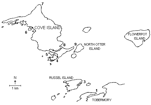
POINTS OF INTEREST
(See Map Below)
- Dunks Bay: Departure point, parking, washrooms and public access to the water. (Note that the beach on either side of the fenced road allowance is privately owned. Please respect the rights of the property owners.)
- Big Tub Lighthouse: Alternate departure and return point, parking and washrooms.
- Flowerpot Island: This is the main visitor area in Fathom Five Park. There are six campsites in Beachy Cove (permits required), plus two mooring docks. In the summertime be prepared for lots of visitors and the busy unloading of the tour boats. After the tour boats leave late in the afternoon you will have most of this magnificent island to yourselves. A loop-hiking trail leads from Beachy Cove to the flowerpots, caves, lighthouse and back across the centre of the island. This area is a botanist’s delight with ferns, mosses and orchids. It is well worth the hike.
- Flowerpots: These geological formations, which give the island its name, were produced as both weather and waves eroded the lower, softer limestone of an exposed bluff the resulting arch eventually collapsed and left behind the flowerpot formation capped as it is by the harder dolomite. Recently park personnel capped these flowerpot formations with cement to help preserve them. It is a pleasure to kayak beside these formations and a great opportunity for photos.
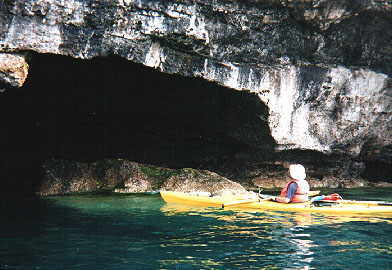
- Ancient Wave Action Caves: Between the flowerpots and the lighthouse at Castle Bluff is a set of ancient caves formed by the action of waves on glacial Lake Algonquin. These caves are now about 30 metres above the current level of Georgian Bay. Only one of these caves is open to the public, but it is impressive enough! The others are closed for both scientific and safety reasons.
- Castle Bluff Lighthouse: The original lighthouse was built in 1897, but was replaced by the current automated lighthouse. Tours are available of the lighthouse keeper’s house near the shore just past the “Castle” if summer residents are present. At the water’s edge are the remains of a dock that was destroyed by a storm in 1987. The limestone cliffs in combination with the white and red buildings are certainly photogenic.
- Flowerpot Island North and West Coasts: The isolated northern cliffs of Flowerpot Island make for an excellent paddling excursion. Here, at the water level, are the beginnings of wave action and talus slope caves. On the exposed shoreline limestone pavements one can get a glimpse into the Silurian past, more than 400 million years ago, when this area was south of the equator. Marine fossils abound, corals, crinoids, brachiopods, and nautiloids.
- Bears Rump Island: Just 3 kilometres to the east of Flowerpot Island is Bears Rump Island. This island is a special ANSI area and camping and fires are not permitted, but it may be visited as a day-trip. Special wave cut-caves and cliff overhangs at the eastern end of Bears Rump combine with terraced cobble beaches to make this a spectacular area. It is not surprising that the oldest cedar trees yet discovered by the Cliff Ecology Group at the University of Guelph were found here – almost 1200 years old.
- Sea Caves in Infancy: Paddling the Otter Island Channel between Cove Island and Otter Island you will pass sections of undercut dolomite, sea caves in the making. Interesting to paddle underneath but be careful of boat wakes.
- Wreck of the P Minch: On the southeastern side of Tecumseh Cove and lying in 5 to 15 metres of water lies the wreck of the three-masted American schooner the P. Minch.
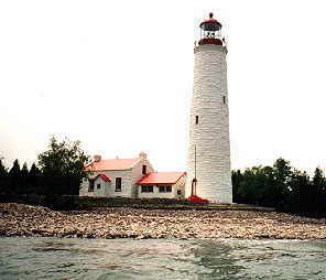
- Cove Island Light: This Imperial Lighthouse, one of only six on the Great Lakes, was built in 1854. It is now automated but if weather conditions permit, it would make an enjoyable stopover for a picnic. Lots of maritime history is associated with this area.

- Islands of Bass Bay: On the northwest section of Cove Island is Bass Bay, a small, exposed bay about three kilometres long, located between Gat Point and Stag Island, and containing a number of small dolomite islands that provide a frame for scenic paddling. About halfway between Stag Island and Ed’s Harbour and nestled on the Cove Island side of a number of small dolomite islands, search for a short portage into Cove Island’s second largest lake. At one time this lake was attached to Lake Huron.
- Boat Passage Harbour: A pleasant location to paddle and, although older topographic maps show an exit onto the eastern edge of Cove Island, the passage of time and frequent storms have closed the eastern end.
- The Gut: This entrance to Cove Island Harbour, or Larondes Harbour, is quite picturesque and best experienced from the seat of a kayak. A building and small wharf identify the harbour.
- Griffon Cove: This half kilometre cove is located on the eastern side of Russel Island. A Tobermory resident, Orrie Vail, claims to have found timbers from LaSalle’s ship, the Griffon, within the shallow waters of the cove.
Shipwrecks: Worthy of a diversion, or as a short trip in its own right, is a visit to two shipwrecks, the City of Grand Rapids and the Sweepstakes, both located at the head of Big Tub Harbour. Only part of the Grand Rapids still remains but the Sweepstakes wreck is almost complete and can be readily glimpsed from your kayak.
ADDITIONAL INFORMATION
Map: 1:50,000 Flowerpot Island (41H/5)
Park Information: For further information contact Fathom Five Park at (519) 596-2233.
This is one in a series of Bruce Peninsula paddling trip descriptions written by Doug Cunningham for the Georgian Bay Committee. It is an expanded version of an article originally published in the Winter 1999 issue of Qayaq.