
by Doug Cunningham
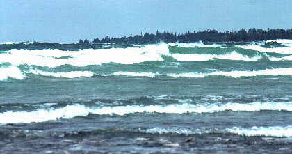
The Lake Huron side of the Bruce Peninsula slopes gently toward the west and cradles warm, almost bathtub-like waters, which are punctuated now and then by smooth sand beaches. Great for swimming or practising your Eskimo roll. Some of the most spectacular sunsets on the Great Lakes can be viewed from the western coast of the Bruce Peninsula.
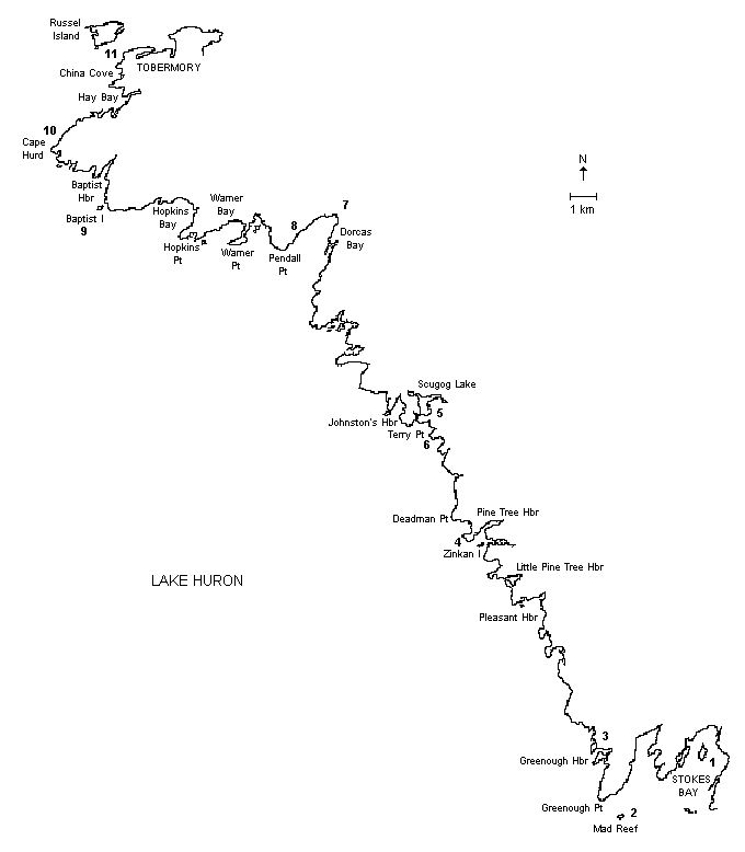
The trip from Stokes Bay to Cape Hurd is a nice two-day excursion. The overall trip is about 40 kilometres in length, but the actual distance will depend on the extent of the exploration done in the many caves and bays. There are a number places to complete the trip: Johnston’s Harbour, Singing Sands in Dorcas Bay, Baptist Harbour near Cape Hurd, or continue all the way to Tobermory.
This paddle will take the kayaker past many inlets, marshes and bays, which are in most cases uninhabited. A few sand beaches, numerous dolomite cobblestone beaches, and smooth limestone pavement await your exploration. Shore birds, unique flora, and yes, the massassauga rattlesnake awaits the inquisitive naturalist.
As you paddle to the northwest you will pass the Dorcas Bay Nature Reserve, home to 15 different species of orchids. The sloping limestone pavement of the Niagara Escarpment cuesta is exposed at many locations between Stokes Bay and Cape Hurd, revealing long grooves called glacial striae. In some places it is possible to see the pitted dolomite, small hemispherical grooves caused by chemical weathering. The 6-kilometre stretch from Indian Harbour through to Cape Hurd is still relatively pristine and a stopover on Baptist Island for a picnic is a nice way to punctuate the trip.
Winds from the south, west, and northwest usually bring broaching or following seas. Be especially cautious as you round Greenough Point, Juno Point, Deadman Point, Terry Point, Pendall Point, Warner Point, Hopkins Point, Baptist Island Point, and Cape Hurd. The shallow waters and reefs extending out from these points of land can produce plunging waves. Always check the weather forecast before departing.
The best time for the trip is May through September. There is cottage development in Stokes Bay between the Stokes River and Tamarack Island, at Pleasant Harbour, Little Pine Tree Harbour, Pine Tree Harbour, Johnston’s Harbour, the west side of Eagle Harbour, the south side of Warner Bay, the east side of Hopkins Bay, Cape Hurd, and the east side of Hay Bay. This development makes finding campsites along the route difficult.
Boat traffic is not a major problem along this coast. The extensive shoals and submerged rocks near the coast provide a challenge for sailors and motorboaters. There is minor traffic out of Stokes Bay on the weekends, and daily boat traffic using the Cape Hurd Channel towards Tobermory. Recently, personal watercraft have been appearing in increasing numbers.
The government dock in Stokes Bay or the Singing Sands Beach in Dorcas Bay are good places to start the trip. Parking is available in both locations. Washrooms are also available at Singing Sands.
POINTS OF INTEREST
(See Map)
- Stokes Bay: The government dock in Stokes Bay is a good starting point. Parking is available.
- Mad Reef: Exercise care when approaching this area because it supports nesting colonies of gulls, cormorants, and terns.
- Greenough Harbour Wetland: This area provides a feeding habitat for wading birds and waterfowl.
- Zinkan Island Cove: This area is classified as an ANSI area and is a complex of flat bedrock, mixed forest and understory plants.
- Scugog Lake Outlet South of Johnston’s Harbour: The outlet from Lake Scugog provides a nice diversion from Lake Huron paddling and provides access, after a short 300 metre portage, to an important waterfowl staging and production area. It makes for a pleasant inland paddle.
- Gas Buoy: This rusting relic provides stark testimony to Lake Huron’s dangerous winds and waves and is located just to the south of the Lake Scugog entrance.
- Singing Sands Beach: Departure Point, parking, washrooms, and lovely sand beach. (With the recent low water levels, the beach has grown considerably, making it a long walk to launch a kayak.)
- Dorcas Bay Nature Reserve: Definitely worthy of a visit! Sand dunes, sand beaches, exposed limestone pavement, an alkline fen, and a jack pine forest await the interested explorer. And what an array of flora; insectivorous plants, such as the sun dew and the pitcher plant, are common and orchids, such as the pink lady’s slipper, are impressive. Over 15 orchid species are represented here. Treat yourself to a great nature hike.
- Baptist Island: This island is a pleasant place to stop for a picnic. The island is privately owned and shelters an unlocked cabin in the eastern, forested section. Sign the guest book.
- Cape Hurd: The submerged reefs and shoals of the Cape Hurd Channel can provide an exciting paddle in westerly and southwesterly winds. It’s no wonder that a number of shipwrecks are located nearby.
- Shipwrecks: The wreck of the China is located in China Cove, submerged in only about 3 metres of water. The wreck of the John Walters is located close to the shore on the southwest side of Russell Island, in 3 to 5 metres of water. The Sweepstakes and the City of Grand Rapids both lie in the water at the west end of Big Tub Harbour at Tobermory.
ADDITIONAL INFORMATION
Maps: 1:50,000 Dyer’s Bay (41 H/3), Dorcas Bay (41 H/4), Flowerpot Island (41 H/5) and Cape Croker (41 A/14)
This is one in a series of Bruce Peninsula paddling trip descriptions written by Doug Cunningham for the Georgian Bay Committee. It was originally published in the Winter 2001 issue of Qayaq.