
A SEA KAYAKER’S PARADISE
by Wendy Killoran
Photos by Jim Gear
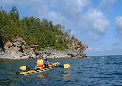
A stack of towering dolomite soared above my kayak as I paddled the jade green water lapping at its base. Mellow light bathed the flowerpot as the sun sank lower in the western sky, almost obscured by the lofty cliff, which is part of the Niagara escarpment, snaking its way sinuously to Flowerpot Island in the Georgian Bay.
My paddling friend, Jim Gear, and I had intended to paddle across the channel separating the northern tip of the spectacular Bruce Peninsula, renowned for its karst topography, to Manitoulin Island, the world’s largest freshwater island. A route following strategically placed islands such as Cove Island, Lucas Island, Yeo Island and Fitzwilliam Island make this crossing a very do-able route when winds are favourable.
But true to my paddling nickname, “Windy Wendy,” and also apparently due to the fact that a full moon would rise into the clear sky that evening, which according to some lunar and weather experts meant increased wind conditions, the crossing would have to wait. But the uncooperative wind conditions weren’t going to affect our paddling opportunity. This stunning area has beguiled my senses since childhood. My hiking boots have clambered over a myriad of trails that penetrate the dense wilderness, including the famed Bruce Trail. Now I would explore this area, Fathom Five National Marine Park, Canada’s first established marine park, from the seat of my kayak.
Loading our kayaks on the wooden dock about thirty centimetres above water level in Little Tub Harbour in Tobermory, I noticed that even in this sheltered refuge for sailboats, fishing boats, tour boats, and the car ferry the Chi-Cheemaun, a stiff wind ruffled the water’s surface. At the slip opposite, I couldn’t help but notice the bright yellow and red “Semi-Submersible Aquaviewer,” a homemade floating contraption riddled with plate-sized oval windows at water’s level. In previous years, this oddball boat had given tours of the area, bringing tourists up close and personal with some of the 22 shipwrecks which litter the shallow turquoise water. Apparently the fellow who made this bizarre marine contraption was so obsessed with looking into the depths of the marine world that he’d created a window in the hull of his kayak but people had looked at him oddly as he’d paddled, continuously staring between his legs! Now he dreams of taking his semi-submersible to British Columbia, not on a flatbed of a train or truck, but via the Panama Canal. Hopefully the waters will provide smooth sailing, as I’d hazard to guess a sea kayak is more seaworthy than this homemade contraption.
Departing Little Tub Harbour under mild, sunny skies, I let the stress of a work week wash away. I’d slept well, in a cozy waterfront cottage, kayaks safely stored across the length of the rustic living room floor. The Chi-Cheemaun had left an hour earlier, it’s belly filled with cars, trucks, and RV’s. My belly was filled with a full breakfast from a local, self-serve restaurant, the Crowsnest.
Heading past parked boats and into the bay entrance, I noticed the Big Tub Lighthouse. Beyond, waves rolled towards me. I hovered at the bay’s entrance as I noticed Jim, who’d paddled quite some distance away from me had disappeared all together. I presumed he’d gone to adjust something behind a stone break wall, sheltered from the gusty wind. Several minutes later he re-emerged, struggling with his rudder.
Our trip evolved spontaneously. Hovering momentarily into the wind and one-metre waves, we decided to head out towards Russel Island rather than hug the shore towards Bruce Peninsula National Park. I dug in with vigour as the wind tried to impede my forward momentum. I’d become strong from extensive paddling throughout the summer. The wind in my face delighted me.
Soon we were sheltered from the wind along the southeast shore of Russel Island where Jim landed and fixed the rudder. In a brisk wind like today’s, it was advantageous and beneficial to have the use of a rudder. We paddled northwards with a northwestern wind pushing one-metre waves towards our port bow. Crossing Macgregor Channel to North Otter Island, Jim sometimes dipped into wave troughs with barely his head visible. Looking to my right, Flowerpot Island and Bears Rump Island lay clearly visible several kilometres away as picture postcard clouds filled the sunny sky.
At North Otter Island we decided to paddle along the eastern shore of Cove Island, the largest by far of the twenty islands that comprise Fathom Five National Marine Park. Only a few islands within the park boundary are privately owned, by wealthy entrepeneurs such as the family responsible for establishing the London Life insurance company. We paddled across the bay where the Charles P. Minch shipwreck lay close to shore, indicated by a red flag for diving boats. Most shipwrecks in the area occurred between the 1850s and 1888, when schooners laden with supplies or lumber navigated the shallow and treacherous waterways, succumbing to powerful storms. With the erection of the lighthouses at Cove Island (1858), Big Tub Harbour (1885), and Flowerpot Island (1897) along with the first complete survey in 1888 of the Georgian Bay by Captain J.G. Boulton, the frequency of shipwrecks in the vicinity declined. By the 1890s, schooners were being replaced by propeller-driven steamers.
A small fishing boat lay in the sheltered leeward side of Cove Island. A beautiful shoreline of rugged dolomite, cliff-like in areas and flattening out to boulder beaches of white rock rimmed the shore. Dense, dark green cedar trees with a sprinkling of deciduous trees climbed inland. I reveled in the beauty surrounding me, intoxicated by the intense contrast of colours, sublime shades of turquoise and jade on the water, off-white rock, deep, verdant green forest and azure blue sky. The essence of natural beauty enveloped me, seeped into my soul, inspired each paddle stroke.
Far to the north, I clearly saw Lucas Island and Yeo Island, merely seven kilometres north of Cove Island, and beyond, a thin faint streak of pale green on the horizon indicated Fitzwilliam Island. They Beckoned but I’d have to decline. In the shelter of Cove Island’s leeward side, I was fooled into believing a crossing was possible, but carefully gazing over the watery horizon, I saw huge waves travelling from west to east, deceiving in size.
Half way up the eastern shore of Cove Island we paused, re-energizing with a snack and liquids. The late September day was brilliant, warm and sunny with nobody else in sight. The Cove Island lighthouse appeared around a bend and southwards, about a kilometre away, the M.S. Chi-Cheemaun plied the Georgian Bay northwards between Echo Island and Cove Island, enroute to South Baymouth on Manitoulin Island, a link to Ontario’s northland. At 110 metres in length, it is the largest vessel of its kind travelling the Great Lakes with a capacity of 143 vehicles and 638 passengers, making the trip several times daily throughout the spring to the fall. Ojibwa for “Big Canoe,” the Chi-Cheemaun’s inaugural sailing occurred in 1974.
At the northern tip of Cove Island, we landed the kayaks along a sheltered rocky shore. Nearby was the colourful red and white lighthouse, now automated. A small community of buildings surrounded the whitewashed lighthouse tower. Gazing upwards, an azure sky dazzled me. A nearby helicopter pad gave evidence to modern improvements from its original construction. I watched carefully as I walked across the shingle rocks, knowing that due to Cove Island’s larger size and closer proximity to nearby islands and the Bruce Peninsula, that it is home to a larger variety of flora and fauna than more remote and smaller Flowerpot Island, and thus home to the endangered, poisonous Massassauga rattle snake as well as black bears. In the warm sunshine, I half expected to encounter a sunbathing snake, but didn’t.
After a leisurely lunch we made an open-water crossing with erratic waves colliding from two different directions to Echo Island. A small cliff plummeted to the turquoise water along the island’s north shore, riddled with caves. Loud echoes of waves colliding against the rock rebounded towards us. Another red flag caught my attention at the northeastern tip of this small island, site of the Arabia shipwreck. Farther to the northeast I saw Snake Island, with a huge tree on the western tip and an unidentifiable structure which appeared to be a manmade structure, perhaps a cottage, on the eastern tip. It looked surreal.
Perky starboard beam waves made for a playful paddle to Flowerpot Island, the jewel of this marine park. By now it was late afternoon. The last tour boat of the day hugged the island’s rocky shoreline, its upper deck filled with colourfully dressed tourists, all gawking at our kayaks paddling on what appeared to be a collision course with the glass-bottomed boat. The first glass-bottomed boat in this area was built in 1975 in Tobermory, used for viewing the well preserved, shallow shipwrecks found in the clearest, most pristine water of the Great Lakes.
Laundry flapped on clotheslines at the lighthouse station, now maintained by volunteers who also welcome day visitors. On the cliff adjacent, stood an unspectacular lighthouse that is replacement for the more interesting original structure.
Rounding the next bend, towering jagged spires of rock, sculpted by the percolating action of water which dissolves the calcite in the rock, we came upon the enchanting Castle Rock, the highest point of land, at 44 metres, and an inspiring site. With the sun having dipped lower towards the horizon, this shore was shaded but also free from wind, which seemed to be abating. Along these cliffs some of North America’s oldest surviving vegetation can be found, including a 1860 year old eastern white cedar, untouched by the ravages of lumbering which occurred extensively on the mainland.
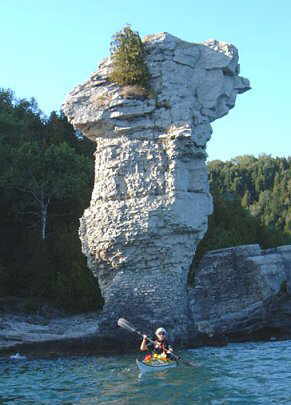
Beyond these enchanting cliffs we came upon the flowerpots, two sea stacks caused by differential erosion. In the days of my childhood I can recall water lapping and pounding at their bases. With such tremendous water level fluctuations recently and throughout the history of the Great Lakes, it didn’t surprise me to find these rock pillars now above the water line and noticeably reinforced with mortar and dolomite at the base and capped with concrete. The first flowerpot we paddled along was the taller, at twelve metres, almost double the height of its neighbour at seven metres. The late afternoon sunshine gave wonderful three-dimensional definition to the photos we shot as we paddled by its base.
Nature is full of superlative wonders. Surely these flowerpots are one of the most distinct and easily recognizable natural features in Canada, similar to the incredible Hopewell Rocks which become land bound during low tide in the Bay of Fundy in New Brunswick, yet are surrounded by murky red water during high tide. I’d seen a similar flowerpot near Dyer’s Bay along the Bruce Trail called the Devil’s Pulpit, but it stands high and dry, many metres above the present day water level, testament again to the previous higher water levels following the glacial melting period from the last ice age 12000 years ago. These whitish grey rocks were formed over 400 million years ago when this area was an inland sea at the equator. Calcareous creatures were deposited over eons, creating the limestone reefs. As the inland sea evaporated, magnesium deposits strengthened and metamorphosed the sedimentary limestone to dolomite, creating both softer and harder layers of rock. The softer limestone layers, subjected to millions of years of erosion, have eroded and dissolved to create the grand sea stacks and impressive sea caves and grottoes this area is famous for, including the large cave many metres above the flowerpots which was not visible from our kayaks.
In lambent light and subdued winds we paddled past the intrusive man-made breakwater of jumbled limestone blocks to Beachy Cove, where we beached our kayaks. Not a soul appeared to be on Flowerpot Island, yet it was a celestial Saturday evening. It was hard to imagine as I’ve seen hundreds of day-trippers here on previous trips, including a wedding at the base of the largest flowerpot.
We read interesting interpretive panels as we walked past the six empty campsites to the loading dock. A chattering red squirrel berated me and sat within arm’s reach of the trail. The refreshing cedar-pine scent filled my nostrils. Red squirrels had made the crossing over the winter ice bridge, unlike chipmunks which are distinctively absent, as are bears and massassauga rattle snakes, as they hibernate throughout the winter, thus not utilizing the frozen bridge which during the winter season connects the island to the mainland. Garter snakes are widely prevalent as are an abundance of rare and common orchids and ferns.
Departing Flowerpot Island, in the calm early evening under a glowing amber sky, we aimed our boats just west of Dunk’s Bay, for the shortest crossing, passing near Middle Island, a rounded hump looking like a stationary hedgehog from a distance. Unbeknownst as I paddled here, I was paddling over the submerged Niagara escarpment, where in its geological past, a river plummeted over the edge, creating a falls more powerful and spectacular than the present day Niagara Falls.
A few motorized pleasure boats were benefitting from the calm, idyllic evening. We paddled past some beautifully situated cottages and homes. The peacefulness of the evening’s sunset was resplendent.
Back in the bay entering Little Tub Harbour at Tobermory, I approached the gigantic Chi-Cheemaun. The boat was docked for the evening, with its bow gaping wide open. I paddled right beside its entire length, touching its port side, and as a photographic joke, filled my empty water bottle from the bilge water used to cool the 7000 hp engine, which flowed in a small arc above my kayak.
We watched the sunset develop and evolve into a deep saturated glowing orange as heavenly rays beamed above the rim-lit cloud, momentarily obscuring the sun. Calmness prevailed. The frisky water that had accompanied us all day long, lay still, as if to enjoy this powerful moment of serenity.
The perfect paddling day was extended with a fresh whitefish dinner at the Lighthouse Restaurant in Tobermory in the solarium, overlooking a clear sky and a white full moon creeping to its zenith, bright like a flashlight. Reminiscing over the beauty of the day’s paddling, I was glad that our intended crossing would have to wait. The Bruce will beckon once again.